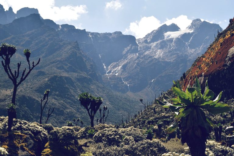
Stepping onto a Mountain Rwenzori hike isn't just a trek; it’s like slipping through a portal into a beautifully surreal, prehistoric world. Nestled within Uganda's Rwenzori Mountains National Park, this legendary "Mountains of the Moon" expedition challenges the soul and rewards it with sights found nowhere else on Earth. Far beyond a standard mountain climb, it offers an immersive journey through five distinct vegetation zones, demanding both grit and a deep appreciation for nature's wildest eccentricities.
Whether you are pushing your physical limits to stand atop the snow-capped Margherita Peak at 5,109 meters, or opting for a shorter, vibrant 28-kilometer trek along the Mahoma Nature Trail, every path reveals a masterpiece. You will find yourself navigating alien landscapes where 12-meter-tall giant senecios tower over you like sci-fi props, and pristine alpine waters like Lake Bujuku mirror the jagged peaks above. It’s a sensory awakening where the call of the endemic Rwenzori turaco—one of over 217 bird species here—echoes through the mist, welcoming you to Africa's ultimate alpine frontier.
Some of the popular Mountain Rwenzori hiking trips
15-days-rwenzori-hiking-safari-and-mountain-gorilla-trekking-vacation
11-days-best-rwenzori-mountain-hike-to-margherita-peak
7-days-mountain-rwenzori-mountain-climbing-active-adventure-to-margherita-peak
5-days-rwenzori-hike-to-either-mountain-sepeke-baker-or-luig-di-savoia
2-days-rwenzori-trek-to-nyabitaba-camp
Summiting Margherita Peak
Conquering the snow-capped Margherita Peak, standing proudly at 5,109 meters above sea level on Mount Stanley, is the ultimate jewel of any Mountain Rwenzori hike. As Africa's third-highest peak, it offers a distinct, thrillingly technical challenge that sets it apart from Kilimanjaro or Mount Kenya. This isn't just a high-altitude walk; it’s a true mountaineering expedition that requires crampons, ice axes, ropes, and a gritty determination to navigate changing glacial terrains.
The push to the summit typically begins in the freezing, pitch-black hours of the early morning, around 2:00 AM or 3:00 AM, from the high-altitude Elena Hut ( ). Climbers must navigate steep, slick rock faces before stepping onto the Margherita Glacier. Over the years, climate change has visibly altered these ancient ice fields, making the traverse a dynamic puzzle of crevasses and steep ice walls. For example, a steep 60-degree ice climb often stands between adventurers and the final rocky ridge.
Reaching the summit signpost at 5,109 meters just as the morning sun pierces through the clouds is an unforgettable milestone. From this vantage point, you are literally standing on the roof of Uganda, looking down at a vast sea of clouds and the sweeping expanses of the Democratic Republic of Congo just across the border. It requires immense physical preparation, as climbers must endure low oxygen levels—roughly 50% less oxygen than at sea level—making every step a lesson in mental fortitude. For experienced trekkers seeking a raw, untamed alpine challenge, this peak delivers an unmatched adrenaline rush and a profound sense of accomplishment.
Exploring Glacier Lakes of Nyamwamba Valley via Kilembe Trail
The Kilembe Trail, pioneered by Rwenzori Trekking Services, offers a dramatic and scenic alternative route that carves directly through the breathtaking Nyamwamba Valley. This trail is highly celebrated for its spectacular approach to the range's remote glacial lakes. Unlike traditional routes, the Kilembe Trail introduces hikers to a stunning, stepped valley system where rushing rivers eventually give way to silent, pristine alpine lakes cradled by sheer rock walls.
Trekking along this route involves ascending through varying camps, such as Samalira Camp ( ) and Kiharo Camp (
 ), where the landscape opens up into a dramatic theater of water and stone. The Nyamwamba Valley is fed by melting glaciers from the peaks above, creating a network of fast-flowing streams and crystalline pools. One of the visual highlights along this circuit is the approach to the twin lakes of Kamugholo and Kachope. Lake Kachope, sitting at an impressive 3,986 meters, is tucked deeply into a steep-sided valley, its deep, dark waters perfectly mirroring the jagged cliffs and giant lobelias that frame its shores.
This Mountain Rwenzori hike option covers roughly 10 to 12 kilometers of trekking per day over a standard 7 to 8-day itinerary. The sheer isolation of the Nyamwamba Valley means you are highly likely to have these spectacular glacial viewpoints entirely to yourself. Walking beside these high-altitude bodies of water, which have been fed by centuries of glacial runoff, provides a serene, meditative contrast to the grueling physical demands of the upper ridges.
Navigating Giant Flora in the Bujuku Valley
If you have ever wondered what it feels like to walk through a real-life Dr. Seuss book or a prehistoric jungle, navigating the Bujuku Valley on the Central Circuit will answer that question. This specific section of the Mountain Rwenzori hike is world-renowned for its surreal, alien-like afro-alpine vegetation, which thrives in the valley's unique microclimate characterized by high rainfall, constant mist, and acidic soils.
As you trek between John Matte Hut ( ) and Bujuku Hut (
 ), you enter a botanical wonderland dominated by 12-meter-tall giant senecios (Dendrosenecio) and massive, prehistoric lobelias that shoot up like leafy obelisks. The ground and the twisted branches of ancient heather trees are heavily carpeted in thick, neon-green mosses that can swell up to 40 to 50 centimeters deep. Walking here feels cushioned and muffled, as if the forest itself is whispering.
The Bujuku Valley is also home to the infamous "Bigo Bog," a massive wetland area where hikers must balance carefully on raised wooden boardwalks—installed to protect the fragile ecosystem and keep trekkers from sinking waist-deep into the mud. Navigating this valley at nearly 4,000 meters above sea level forces you to slow down, not just because of the thinning air, but because the sheer scale of the flora is mesmerizing. Seeing a flower spike that towers 3 to 4 times your own height against a backdrop of mist-shrouded vertical cliffs is a humbling reminder of nature’s ability to evolve into the beautifully bizarre.
Trek to Glacial Lakes (Lake Bujuku and Lake Kitandara)
Beyond the grueling peak ascents, a Mountain Rwenzori hike is defined by its journeys to the stunning, deeply spiritual alpine waters of Lake Bujuku and Lake Kitandara. These high-altitude lakes act as geographic landmarks and emotional sanctuaries for hikers, offering places of quiet reflection amidst some of the most rugged topography on the African continent.
Lake Bujuku, sitting at an elevation of 3,891 meters, lies at the apex of the Bujuku Valley, squarely positioned in a deep glacial trough between three of the range’s highest massifs: Mount Stanley, Mount Baker, and Mount Speke. On a clear morning, the lake serves as a flawless, glassy mirror, reflecting the stark, dark rock faces and white snow patches of Mount Stanley. The stillness of the water at this altitude, contrasted with the towering, jagged peaks above, creates an incredibly dramatic, theater-like atmosphere.
Further along the Central Circuit, after crossing the grueling 4,450-meter Scott-Elliot Pass, hikers descend into the spectacular valley housing Lake Kitandara. Consisting of two interconnected lakes sitting at 4,023 meters, Kitandara is widely considered one of the most beautiful spots in the entire national park. The water here is often a striking, deep emerald green, framed perfectly by groves of giant senecios and colorful alpine wildflowers. The Kitandara Hut sits right on the shoreline, allowing weary trekkers to sit by the water's edge at sunset, listening to the gentle lap of alpine waves while the temperature drops rapidly toward 0°C (32°F).
Bird Watching in the Afro-Montane Forest
For avid birders, a Mountain Rwenzori hike is nothing short of a pilgrimage. Rwenzori Mountains National Park is a recognized Important Bird Area (IBA) and harbors an incredible diversity of avian life, boasting over 217 recorded bird species. The true prize for bird watchers lies in spotting the 19 Albertine Rift endemics—species that cannot be found anywhere else on the planet outside of this specific mountain corridor.
As you begin your trek in the lower Afro-montane forest zone, between 1,600 and 2,500 meters, the canopy comes alive with a symphony of calls. The undisputed superstar of the forest is the Rwenzori turaco, a spectacularly colored bird with vibrant green plumage, a deep blue crest, and brilliant crimson wing patches that flash brilliantly when it takes flight through the misty canopy. Hearing its loud, raucous caw echoing through the valley is a signature Rwenzori experience.
As you climb higher into the bamboo and heather zones, the bird composition shifts. You will want to keep your binoculars trained for the mountain chat, a resilient little bird that flits along the rocky trails, and the striking crimson-winged finches. Other notable species include the handsome francolin, the olive pigeon, and the tiny, hyperactive Rwenzori double-collared sunbird, which darts frantically between the nectar-rich blooms of the giant lobelias at altitudes exceeding 3,000 meters. With a patient guide, a single day’s trek can easily yield a checklist of 30 to 40 distinct species, making the heavy camera gear well worth the carry.
Spotting Rare Wildlife in Bamboo and Heather Zones
While the Rwenzori range is not a traditional savannah destination packed with large herds of game, a Mountain Rwenzori hike offers wildlife enthusiasts a rare chance to spot highly specialized, evolutionarily unique creatures. The dense bamboo and heather zones, spanning elevations between 2,500 and 3,500 meters, hide an array of shy, fascinating animals that have perfectly adapted to this cold, montane environment.
The undisputed highlight of a wildlife scan here is the three-horned chameleon (Trioceros johnstoni). Found primarily in the bamboo thickets, these miniature, prehistoric-looking reptiles can grow up to 30 centimeters in length. The males boast three prominent, fierce-looking horns on their heads, used for jousting over territory. Because they move in slow, deliberate, rhythmic sways to mimic shaking leaves, spotting one requires a sharp eye or the expert tracking skills of a local Bakonzo guide.
Looking up into the bamboo stalks, you are also likely to spot troupes of velvet monkeys and the striking, thick-furred Angola colobus monkeys, leaping gracefully across the canopy despite the chilly mountain mists. Scurrying along the mossy forest floor or up the gnarled trunks of heather trees are several species of indigenous montane squirrels, including the Rwenzori sun squirrel. While larger mammals like the elusive Rwenzori leopard or the montane bushback are incredibly rare to glimpse, finding their fresh tracks in the soft mud at 3,000 meters adds a thrilling layer of mystery to the trek.
Community & Forest Walks
Not every adventure in this region requires crampons and heavy alpine gear. Engaging in community and forest walks around the base of the mountains provides an enriching, deeply human perspective to your Mountain Rwenzori hike, highlighting the vibrant culture of the people who have lived in the shadow of these peaks for generations.
A fantastic option for those seeking a shorter, non-technical mountain experience is the 28-kilometer Mahoma Nature Trail. Typically completed as a 3-day loop or a rigorous day hike, this trail takes you through pristine lower-altitude forests, over rushing rivers via hanging footbridges, and past the beautiful Mahoma Lake. It offers a spectacular sample size of the park’s famous eco-zones, topping out at around 3,000 meters, making it a perfect acclimatization walk or a standalone trek for casual hikers.
Complementing the natural wilderness is a visit to Ruboni Village, nestled at the gateway of the central trekking circuit. Here, you can immerse yourself in the rich culture of the Bakonzo people, the traditional keepers of the mountains. On a guided community walk, you can visit a traditional healer, watch energetic cultural dance performances, and learn how the locals utilize the forest for medicine and food. Interacting with the Bakonzo—many of whom work as the expert porters and guides on the high peaks—gives you a profound appreciation for their relationship with the "Rwenzururu" (the place of snow). It transforms your journey from a purely physical climbing challenge into a holistic cultural exchange.
When is the best time for Mountain Rwenzori hike
Timing is everything when tackling the unpredictable weather of the "Mountains of the Moon." The absolute best windows for a Mountain Rwenzori hike are during the dry seasons: from June to August and from December to February. During these months, you will experience significantly less rainfall, clearer skies, and firmer bog conditions, which makes navigating steep ridges and slippery boardwalks much safer.
While the mountains can technically be climbed year-round, attempting a trek during the heavy rainy seasons—March to May and September to November—transforms the trails into deep, waist-high mud traps and blankets the peaks in thick, perpetual mist. Temperatures at the base average a comfortable 20°C to 25°C, but as you push past 4,000 meters, they easily plummet below 0°C at night. Choosing the dry season maximizes your chances of catching breathtaking, unobstructed sunrise views from Margherita Peak.
What to pack for Mountain Rwenzori hike
Packing for a Mountain Rwenzori hike requires preparing for extreme weather contrasts, shifting from hot, humid jungles to freezing alpine glaciers. Layering is your best friend. You must pack high-quality moisture-wicking base layers, a thick fleece, and a 100% waterproof jacket and trousers to withstand the frequent afternoon downpours.
For the muddy bog sections, heavy-duty, waterproof leather hiking boots and a pair of tall rubber gumboots (wellies) are absolute essentials. If you are aiming for Margherita Peak, you will also need technical mountaineering gear, including a climbing harness, crampons, an ice axe, and warm, insulated gloves. Don't forget a rated -10°C sleeping bag, a reliable headlamp with extra batteries for summit night, and polarized sunglasses to protect your eyes from intense glacial glare. Pack everything inside durable waterproof dry bags to ensure your clothes stay bone-dry throughout the trek.
How to train for Mountain Rwenzori hike
A Mountain Rwenzori hike is widely considered more physically demanding than climbing Kilimanjaro due to its steep, technical terrain and muddy bogs. To prepare, you should start a dedicated training regimen at least 3 to 4 months before your trip. Focus heavily on cardiovascular endurance and leg strength. Long-distance running, cycling, and rowing are excellent for building stamina.
However, the most effective training is weighted stair-climbing or hiking on steep local trails. Try walking for 4 to 6 hours with a 10kg backpack to condition your lower back, core, and legs for the daily grind. Incorporate strength training like squats, lunges, and calf raises to protect your joints on steep descents. Because you will be pushing your limits above 5,000 meters where oxygen levels drop by half, training your body to endure prolonged physical exertion will make your acclimatization smoother and your trek far more enjoyable.
Where to stay on Mountain Rwenzori hike
Accommodation options vary greatly depending on whether you are relaxing at the base or pushing up the mountain ridges. Before and after your Mountain Rwenzori hike, you can relax in comfort at base hotels like Equator Snow Lodge, which features cozy wooden cabins with stone fireplaces, or Ruboni Community Camp for an authentic, eco-friendly local experience.
Once you pass the park gates and head up into the wilderness, your accommodation shifts to rustic mountain huts managed along the trekking circuits. On the Central Circuit, you will stay in basic, communal wooden cabins equipped with bunk beds and mattresses, such as John Matte Hut () or Bujuku Hut (). If you choose the Kilembe Trail, you will sleep in sheltered, weather-resistant tents set up on wooden platforms at designated camps. These high-altitude sanctuaries provide vital shelter from the freezing winds, offering a cozy space to share hot meals and stories with your crew.
How to get to Mountain Rwenzori Park
Getting to Rwenzori Mountains National Park is an adventure in itself, taking you from the bustling heart of Kampala deep into Western Uganda near the DRC border. The most common route is by road, which takes about 6 to 7 hours. You can travel via Kampala-Fort Portal (approx. 300 km), a scenic drive that winds past beautiful tea plantations, or via the Kampala-Mbarara-Kasese highway (approx. 350 km), which offers a chance to cross the equator.
If you prefer to save time and skip the long drive, you can book a 60-minute domestic charter flight from Entebbe International Airport to the Kasese Airstrip. From Kasese town, the park headquarters at Nyakalengija or Kilembe are just a short 40-minute drive away. Whichever travel option you choose, the sight of the towering, mist-shrouded peaks rising sharply from the savannah floor lets you know you have arrived at Africa's ultimate alpine frontier.
Booking Mountain Rwenzori hike with us Roads of Adventure safaris
When you book your Mountain Rwenzori hike with Roads of Adventure Safaris, you aren't just hiring a tour company; you are partnering with a passionate team dedicated to turning your bucket-list dream into a safe, unforgettable reality. We handle all the logistics from start to finish, including securing park permits, arranging seamless 4x4 ground transport, and booking comfortable accommodations before and after your climb.
Our itineraries are thoughtfully crafted with built-in acclimatization days to give you the highest possible summit success rate. Most importantly, we partner with the most experienced local Bakonzo guides, skilled chefs, and resilient porters who know every inch of these mountains. From providing top-tier safety gear to preparing hot, nourishing meals at 4,000 meters, we ensure you are fully supported every single step of the way. Let us handle the details while you focus on conquering the majestic Mountains of the Moon!