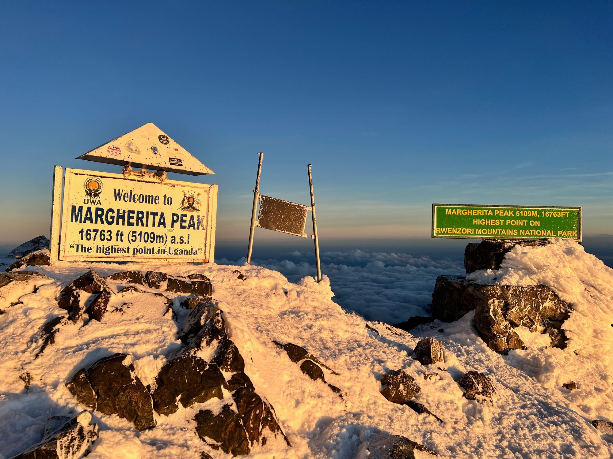
Yes, Margherita Peak is the highest point in Uganda, located on Mount Stanley in the legendary Rwenzori Mountains (on the border between Uganda and the Democratic Republic of Congo), it stands at an elevation of 5,109 meters (16,762 feet). This makes it the third-highest mountain peak in all of Africa, surpassed only by Mount Kilimanjaro and Mount Kenya.
Some of the popular Mountain Rwenzori hiking trips
15-days-rwenzori-hiking-safari-and-mountain-gorilla-trekking-vacation
11-days-best-rwenzori-mountain-hike-to-margherita-peak
7-days-mountain-rwenzori-mountain-climbing-active-adventure-to-margherita-peak
5-days-rwenzori-hike-to-either-mountain-sepeke-baker-or-luig-di-savoia
2-days-rwenzori-trek-to-nyabitaba-camp
The Location (A Wild, Transboundary Frontier)
Nestled deep within the equatorial heart of the continent, Margherita Peak occupies a dramatic and politically unique position. It stands tall right on the international border separating western Uganda from the Democratic Republic of the Congo (DRC).
This geographical placement means that as you stand on its icy summit, you are literally straddling two nations. On the Ugandan side, the peak is protected within the pristine Rwenzori Mountains National Park, a UNESCO World Heritage Site famous for its surreal, mist-shrouded "Mountains of the Moon." On the Congolese side, it plunges into the vast, dense wilderness of Virunga National Park.
Because of this remote, transboundary location, the peak acts as a magnificent natural wall between East Africa and the Congo Basin. This isolated frontier has kept the surrounding ecosystems remarkably untouched, offering modern adventurers a rare glimpse into a truly wild and ancient African landscape.
Africa's Rank (A Bronze Medalist in the Clouds)
When people think of mountaineering in Africa, giants like Kilimanjaro and Mount Kenya usually dominate the conversation. However, Margherita Peak proudly claims the bronze medal as the third-highest peak in all of Africa, standing at a staggering 5,109 meters (16,762 feet).
While it may sit just behind its more famous East African neighbors in height, it easily rivals them—and arguably surpasses them—in sheer mystique and drama. Because it is much less commercialized than Kilimanjaro or Mount Kenya, reaching this altitude feels like an exclusive achievement.
You aren't sharing the trails with massive crowds here. Instead, standing at Africa’s third-highest vantage point offers a profound sense of solitude. Looking out over the vast Rwenzori range from Margherita Peak gives you the distinct, exhilarating feeling of being on top of the world, far away from civilization.
The Climb (A True Alpine Challenge)
Unlike the sweeping, volcanic slopes of Kilimanjaro or Mount Kenya, Mount Stanley is a non-volcanic, tectonically uplifted massif. This unique geological origin means the terrain is exceptionally rugged, steep, and jagged.
Consequently, a trek to Margherita Peak is vastly different from a standard high-altitude walk; it is a challenging, technical alpine expedition. As you near the roof of Uganda, the mud and giant lobelias give way to exposed rock, steep ridges, and actual equatorial glaciers.
Reaching the summit requires proper mountaineering gear, including crampons, ice axes, and harnesses. Climbers must navigate roped team sections to safely traverse the cracking ice fields and conquer a final, thrilling scramble up slick, vertical rock faces. It is a demanding physical and mental test, making the moment you finally touch the summit marker infinitely more rewarding for true adventure purists.
Which specific mountain range is home to Margherita Peak?
Margherita Peak is cradled within the spectacular Rwenzori Mountains, a legendary mountain range stretching along the border of western Uganda and the Democratic Republic of the Congo. Unlike the volcanic solitary peaks frequently found throughout East Africa, the Rwenzoris are a massive, non-volcanic block of crust that was forcefully uplifted by tectonic forces millions of years ago. This extensive range spans roughly 120 kilometers in length and 65 kilometers in width, characterized by deep, plunge-cut valleys, steep ridges, and an array of rugged massifs. Margherita Peak itself sits proudly atop Mount Stanley, which is the largest and highest individual massif within the broader Rwenzori range. The unique geography of this specific range creates a completely isolated ecosystem, transforming the slopes into a wonderland of giant lobelias, dense bamboo forests, and mist-covered wetlands. For trekkers exploring these jagged coordinates, the mountain range offers an incredibly dramatic, prehistoric backdrop that makes the journey feel entirely distinct from any other alpine trail in Africa. It is a wild, complex maze of rock and ice that perfectly showcases the raw geological power of the Great Rift Valley system.
How tall is Margherita Peak above sea level?
Margherita Peak stands at a breathtaking elevation of 5,109 meters (16,762 feet) above sea level, officially securing its place as the highest point in Uganda. At this towering altitude, the atmosphere becomes notably thin, containing roughly half the oxygen concentration found at sea level, which presents a significant physiological challenge for climbers aiming for the top. Achieving this elevation requires gradual acclimatization over several days to avoid the debilitating effects of acute mountain sickness. The sheer height of the peak means that despite its location just north of the equator, the summit temperatures routinely plummet well below freezing, allowing massive alpine glaciers to survive amidst the tropical latitudes of Central Africa. Standing at over 5,100 meters, the peak dramatically pierces the regional weather systems, frequently cloaking itself in dense clouds and receiving heavy snowfalls that constantly replenish its icy cap. For mountaineers, reaching this specific altitude marker represents a profound physical triumph. Looking down from 5,109 meters provides an unparalleled vantage point over the sweeping Congolese rain forests and the rugged Ugandan valleys, offering an unforgettable feeling of standing on the true roof of the country.
Is Margherita Peak part of the "Mountains of the Moon"?
Yes, Margherita Peak is the highest point within the legendary "Mountains of the Moon." This evocative title dates back nearly two thousand years to around 150 AD, when the ancient Alexandrian geographer and astronomer Claudius Ptolemy wrote about a mysterious, snow-capped mountain range deep in the heart of Africa whose melting glaciers fed the source of the Nile River. For centuries, European cartographers and explorers debated whether these snowfields actually existed so close to the equator, often treating them as a myth. It wasn't until the late 19th century that modern explorers finally confirmed Ptolemy’s descriptions matched the mist-shrouded, glaciated peaks of the Rwenzori range. Today, the romantic moniker perfectly captures the surreal, otherworldly atmosphere of the landscape surrounding Margherita Peak. Trekkers navigating the high valleys will encounter bizarre, alien-like vegetation, giant groundsels, and moss-draped heather forests that feel entirely disconnected from the typical African savanna below. Margherita Peak serves as the ultimate crowning jewel of this historic, mythic range, keeping the ancient legend alive for every modern adventurer who walks through its perpetually misty, high-altitude dreamscapes.
Who was Margherita Peak named after?
Margherita Peak was named in honor of Queen Margherita of Italy, a beloved royal figure who reigned alongside King Umberto I during the late 19th and early 20th centuries. The peak received its regal title in 1906 during a historic, highly successful mountaineering expedition led by her nephew, Prince Luigi Amedeo of Savoy, who was famously known as the Duke of Abruzzi. The Duke was a fiercely accomplished alpine explorer who sought to map the mysterious Rwenzori range with absolute scientific precision. Upon successfully conquering the highest, most formidable summit of Mount Stanley, he chose to dedicate the crowning point of the massif to the Italian Queen as a tribute to her royal patronage and her personal enthusiasm for mountaineering culture. Queen Margherita was well-known for her sharp mind, her strong support of the arts and sciences, and her love for the Italian Alps, making the dedication fitting. By placing her name on the map of equatorial Africa, the Italian expedition left a permanent historical stamp on the region, connecting a classic European monarchy to one of the most rugged, wild, and remote mountain peaks on earth.
Who were the first explorers to reach the summit of Margherita Peak?
The first explorers to successfully stand on the summit of Margherita Peak were members of a landmark Italian expedition led by Prince Luigi Amedeo of Savoy, the Duke of Abruzzi, in June 1906. While previous European expeditions had caught glimpses of the range or explored the lower valleys, none had possessed the technical alpine expertise required to conquer the glaciated peaks. The Duke of Abruzzi assembled a highly skilled team that included professional alpine mountain guides Joseph Petigax and César Ollier, alongside the expert porter and guide Laurent Brocherel. Together, this tight-knit team navigated the treacherous, uncharted glaciers of Mount Stanley, cutting steps into the steep ice and securing ropes across vertical rock faces to reach the ultimate high point. Their historic achievement was a masterpiece of early 20th-century exploration; not only did they summit the highest peak, but they also systematically mapped all six major massifs of the Rwenzori range, took extensive photographs, and collected invaluable botanical data. Their flawless execution laid the foundational groundwork for modern mountaineering routes, ensuring their names remain permanently etched into African climbing history.
Where does Margherita Peak rank in height among all the mountains in Africa?
Margherita Peak proudly claims the bronze medal as the third-highest mountain peak in all of Africa, positioned just behind Tanzania's world-famous Mount Kilimanjaro (5,895 meters) and Kenya’s striking Mount Kenya (5,199 meters). While it sits slightly lower in absolute altitude than its East African neighbors, Margherita Peak easily matches them—and often surpasses them—when it comes to pure wilderness intrigue and technical complexity. Unlike Kilimanjaro, which can be reached via a high-altitude hike on established walking trails, Margherita Peak demands authentic mountaineering skills, requiring climbers to cross real crevassed glaciers and scramble over exposed, technical rock walls. Because the Rwenzori range is significantly less commercialized and sees far fewer annual visitors than Africa's top two peaks, reaching this third-highest summit offers an exclusive, deep sense of wilderness solitude. For adventure purists, the ranking is less about the numbers and far more about the sheer effort required to get there. Conquering Africa's third-highest point is widely considered by international mountaineers to be the most authentic, physically demanding, and rewarding alpine summit challenge on the continent.
Does Margherita Peak have glaciers, and are they permanent?
Yes, Margherita Peak is home to remarkable equatorial glaciers, though their status as "permanent" is rapidly changing due to global climate shifts. These high-altitude ice sheets, including the prominent Margherita Glacier, have clung to the steep rock faces of Mount Stanley for thousands of years, surviving directly under the intense tropical sun thanks to the extreme cold of the 5,109-meter elevation. However, scientific surveys reveal that the Rwenzori glaciers are retreating at an alarming rate. Over the last century, a massive percentage of the range's total ice cover has completely vanished, with scientists predicting that these equatorial glaciers could disappear entirely within the coming decades. Currently, the glaciers still require technical ice-climbing techniques to cross, featuring deep crevasses, slick bergschrunds, and changing ice bridges that guides must carefully evaluate every season. While they are technically permanent in the sense that they remain year-round rather than melting seasonally, their long-term survival is deeply threatened. This makes climbing Margherita Peak today an incredibly special, time-sensitive privilege, allowing mountaineers to witness a vanishing glacial landscape right in the heart of Africa.
What kind of climbing gear is required to reach the summit of Margherita Peak?
Reaching the snowy summit of Margherita Peak is a serious technical undertaking that requires specialized alpine mountaineering equipment. Unlike standard trekking routes, you cannot simply walk to the top; you must be prepared to traverse real glaciers and scramble up steep, exposed rock faces. Every climber must wear a professional climbing harness and carry a sharp ice axe, which is essential for balance, cutting steps, and performing self-arrest maneuvers if a slip occurs. Heavy-duty mountaineering boots compatible with rigid, steel crampons are absolutely non-negotiable for securing traction on the slick, steeply angled Margherita Glacier. Furthermore, teams must travel roped together using dynamic climbing ropes, using ice screws, snow pickets, and carabiners to set up safety anchors across crevassed zones. A high-quality climbing helmet is required to protect against potential rockfalls, while specialized outdoor clothing—including waterproof outer layers, heavy thermal insulation, and insulated gloves—is vital to combat the sub-zero temperatures and biting winds near the top. Having the correct gear and knowing exactly how to use it ensures a safe, successful push to the roof of Uganda.
How many days does a standard trekking expedition to the summit of Margherita Peak take?
A standard trekking expedition to the summit of Margherita Peak typically takes between 7 to 9 days, depending on the chosen route and the physical fitness of the climbers. The two primary paths are the classic Central Circuit Route, which usually requires 7 to 8 days, and the popular Kilembe Trail, which is typically organized as an 8 to 9-day itinerary. This extended timeframe is structurally necessary for safety, as rushing up to 5,109 meters without giving your body time to adjust to the thinning air drastically increases the risk of severe altitude sickness. The daily schedule involves steady, intentional hiking through distinct ecological zones, starting in the low-elevation tropical rainforests, climbing up through bamboo and giant heather marshes, and finally resting at high alpine camps like Elena Hut (4,541 meters) before the final midnight summit push. Taking 8 days allows for a crucial built-in acclimatization day, which helps climbers maintain their energy, adapt to the altitude, and safely handle the technical rope work required on the summit glacier. The deliberate pace ensures an unforgettable, well-paced mountaineering experience.
Booking Rwenzori hike with us Roads of Adventure safaris
Booking your legendary Rwenzori trek with Roads of Adventure Safaris is a smooth, straightforward process designed to get you from your screen to the slopes seamlessly.
First, head over to our website to explore the different expeditions we offer. We have routes tailored for every pace and ambition, whether you are looking for the classic 9-day summit push to Margherita Peak or an epic, immersive 15-day mountaineering adventure across the entire range.
Once you’ve picked your ideal itinerary, we take the heavy lifting completely off your shoulders. As a fully licensed and registered operator, we handle all the tedious logistics behind the scenes—from securing your official trekking permits to coordinating our expert local guides, porters, and mountain gear. We pave the way so you can focus entirely on training, packing, and enjoying the climb of a lifetime.