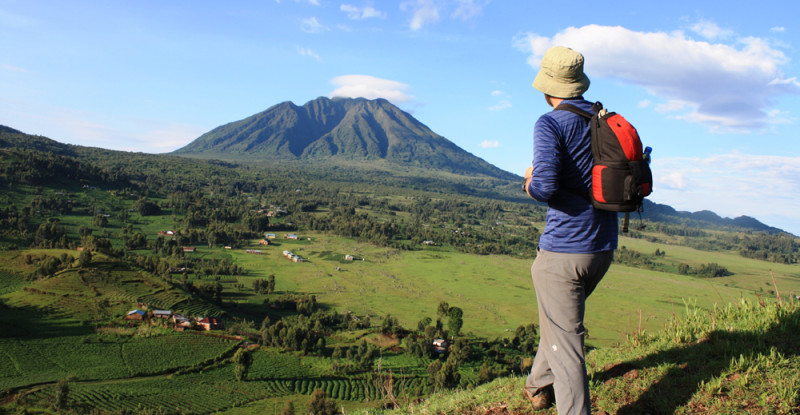
Hiking Mount Sabinyo (3,669m) is a challenging full-day trek starting from Mgahinga Gorilla National Park in southwestern Uganda. Known as the "Old Man’s Teeth" due to its jagged peaks, the summit is uniquely positioned at the precise point where the borders of Uganda, Rwanda, and the Democratic Republic of Congo meet, allowing you to stand in three countries simultaneously
30-days-best-uganda-birding-safari-extravaganza-and-wildlife-safari
30-days-uganda-rwanda-photography-safari-adventure
4-days-best-gorilla-trekking-and-mountain-sabinyo-hike
Where is the Hiking Mountain Sabyinyo experience located?
Hiking Mountain Sabyinyo takes place in Mgahinga Gorilla National Park, in the southwestern corner of Uganda’s Kisoro District. Mgahinga is one of Uganda’s smaller national parks and forms part of the larger Virunga Conservation Area, a transboundary complex of protected areas that includes Parc National des Volcans in Rwanda and Virunga National Park in the Democratic Republic of Congo. Geographically, Sabyinyo’s massif straddles the meeting point of these three countries; however, the officially sanctioned and managed hiking route begins inside Uganda at the Mgahinga park headquarters near the Kisoro region.
Access for international visitors is typically arranged from Kisoro town, which functions as the logistics hub for Mgahinga activities (gorilla trekking, golden monkey tracking, and peak hikes). Kisoro is reachable by road from Kampala (an overnight or early‑morning drive of roughly 8–10 hours) or by a short domestic flight to Kihihi or Kisoro airstrips when available. Park entry, permits, experienced guides and porters for the Sabyinyo hike are coordinated through Uganda Wildlife Authority (UWA) and licensed local operators; these arrangements are important because the trail requires supervision for safety and conservation compliance.
Although Sabyinyo’s summit touches the international borders, the hiking experience as offered to tourists is managed by Uganda authorities. The trailhead, guide briefings, safety checks, and permit processing are all done on the Ugandan side, ensuring that hikers follow established, low‑impact routes and that rescue or emergency procedures are in place. The park’s location—at the tri‑point of three nations—adds a strong geopolitical and scenic dimension to the hike: on a clear day you can stand at the summit and literally look into Rwanda and DRC while being within Uganda’s conservation jurisdiction. This setting makes Sabyinyo a distinctive hike for visitors aiming to combine high‑altitude trekking with primate encounters and transboundary natural history.
Why is it called Hiking Mountain Sabyinyo?
The name “Sabyinyo” derives from the Kinyarwanda language and is commonly translated as “Old Man’s Teeth.” This evocative toponym refers to the mountain’s serrated, tooth‑like skyline: a series of jagged rocky summits and knife‑edged ridgelines that, when viewed from certain angles, resemble worn, exposed teeth of an aged figure. Local naming traditions often draw on visual metaphors to describe landscape features, and Sabyinyo’s distinctive outline made the “Old Man’s Teeth” image a natural cultural association for communities living in and around the Virunga slopes.
Beyond the literal translation, the name carries cultural resonance. In many East African societies, place names encapsulate oral histories, local metaphors, and relationships between people and land. Naming a peak “Old Man’s Teeth” anthropomorphizes the mountain and makes it a memorable feature in navigational knowledge, storytelling and traditional ecology. The jagged summit is not just aesthetic; it reflects the mountain’s volcanic geology and long history of erosion that carved steep ridges and sharp rocky outcrops—hence the “teeth.”
The descriptive name also hints at the technical and rugged character of the hike. The serrated skyline foreshadows the steep, exposed and sometimes laddered sections of the trail that demand careful footing and stamina. For visitors, the name serves both as a vivid image and a practical cue—Sabyinyo is visually striking and physically demanding. At the summit, the peaks’ shape reinforces the origin of the name: standing among the stony ridges, with panoramic views across Uganda, Rwanda and the DRC, hikers gain a direct appreciation for why local languages gave the mountain this memorable label.
Can I do Hiking Mountain Sabyinyo from Rwanda or Congo?
Although Mount Sabyinyo’s massif spans Uganda, Rwanda and the Democratic Republic of Congo, the official, established and tourist‑accessible hiking trail is operated only from the Uganda side, inside Mgahinga Gorilla National Park. The Ugandan route is the only one that offers licensed guide services, regulated permits, and ranger‑managed safety protocols for public hiking. This status reflects practical, safety and conservation reasons: the Ugandan side provides a controlled, maintained path that has been cleared, laddered in technical sections, and integrated into the park’s visitor‑management system.
On the Rwandan and Congolese flanks, the terrain is far steeper, more rugged, and less developed for recreational access; those sides of the mountain are not generally open to organized public hikes. In Rwanda, the emphasis in the Virunga area is typically on gorilla trekking in Parc National des Volcans, and established public trails to Sabyinyo’s summit are not maintained. In the DRC, security considerations, limited tourism infrastructure, and ongoing conservation priorities have historically made access more restricted and unsafe for casual hikers.
Because Sabyinyo crosses international borders, any attempt to approach the summit from another country would present additional legal and logistical complications—including border formalities, permits from different national authorities, and potential security checks. Crossing international borders on foot at a mountain summit is not permitted without explicit authorization from the respective governments and border control agencies.
Therefore, for safety, legality and convenience, visitors should plan hikes from the Mgahinga (Uganda) side. Doing so ensures you have trained Ugandan guides, porters, and ranger support, as well as coordinated emergency procedures. Reaching the tri‑border vantage point from the official Ugandan trail remains the only responsible and commonly practiced option for tourists.
What makes Hiking Mountain Sabyinyo unique?
Hiking Mountain Sabyinyo is unique for several interlocking reasons: its tri‑national summit, unusual jagged morphology, high‑altitude Afro‑montane ecosystems, and the combination of geological and cultural significance. The most celebrated feature is that Sabyinyo is one of the rare places in the Virunga volcanic chain where hikers can stand at a point that overlooks three countries—Uganda, Rwanda and the Democratic Republic of Congo—simultaneously. That geopolitical convergence offers a powerful visual and symbolic experience, linking natural history with human geography.
Physically, Sabyinyo’s serrated ridge and jagged summits set it apart from smoother volcanic cones. Its “Old Man’s Teeth” silhouette reflects volcanic origins followed by prolonged erosion that carved steep, rocky ridges and exposed crags. This terrain produces a technical and dramatic hiking route—complete with ladders in steep sections—and panoramic vistas from the higher peaks that include the distant Rwenzori, neighboring Virunga peaks, and sweeping valley escarpments.
Ecologically, the mountain supports Afro‑montane habitats—bamboo forests, Hagenia–Hypericum forest zones and high‑altitude grasslands—that harbor specialized flora and fauna. These habitats are also home to charismatic species such as mountain gorillas (in adjacent areas of the Virungas), golden monkeys (which are tracked within Mgahinga), and a range of montane bird species. The juxtaposition of primate tracking opportunities, high‑altitudinal trekking and tri‑border views makes Sabyinyo a compact, multi‑disciplinary nature experience.
Culturally, the massif carries local significance for communities on all three sides, and the name itself—Sabyinyo—encapsulates a local morphological metaphor. Finally, the hike’s combination of technical challenge, close contact with dramatic volcanic geology, and the chance to stand in three countries at once gives Sabyinyo an unusual appeal for adventurous trekkers seeking both physical challenge and a strongly memorable, almost symbolic summit experience.
What is the elevation reached during Hiking Mountain Sabyinyo?
The Sabyinyo hiking route reaches approximately 3,669 meters (about 12,037 feet) above sea level at its highest point—the summit of the third and highest peak in the serrated ridge. This elevation places Sabyinyo among the higher peaks of the Virunga volcanic chain, producing distinct high‑altitude conditions that affect climate, vegetation and trekking demands. As you ascend from the Mgahinga parkhead (which itself is already at high elevation), you move through significant ecological zones: lower montane forest, bamboo and then higher Afro‑alpine grasslands and rocky summit zones.
The altitude influences both the visual experience and physiological considerations. Weather at 3,600+ meters can be unpredictable—rapid temperature swings, strong winds, cloud cover and reduced oxygen availability can all affect hikers. Many trekkers experience cooler temperatures and require layered clothing; mornings may be crisp while midday sun can be strong. For some individuals, especially those not acclimatized to higher elevations, the ascent may produce mild altitude effects (shortness of breath on steep sections, increased fatigue). Guides and operators typically advise a steady pace, adequate hydration, and attention to pacing to reduce the risk of altitude‑related discomfort.
From the summit at 3,669 meters, panoramic views open across the Virunga range and surrounding landscapes on clear days—Rwanda’s Parc National des Volcans, parts of the DRC’s highlands, and Uganda’s rolling volcanic foothills. The summit’s elevation also places hikers within rare high‑altitude habitats that support unique plant communities and specialized fauna. Because the trail reaches this substantial height in a single demanding day, physical fitness, proper clothing, and awareness of high‑altitude conditions are important considerations for a safe and rewarding climb.
How long does Hiking Mountain Sabyinyo take?
Hiking Mountain Sabyinyo is typically a full‑day, one‑day activity that commonly takes between seven to ten hours for a round trip, though actual duration depends on conditions, group fitness, weather and the exact itinerary set by guides. Most operators schedule an early morning departure from the Mgahinga parkhead so hikers can begin the ascent in cool, stable conditions and reach the higher ridgelines before midday weather becomes variable. The ascent itself is steep and physically demanding and often requires careful negotiation of muddy slopes, exposed rocky sections and fixed wooden ladders. These technical elements naturally slow progress and require short rests and team assistance.
Trail conditions can lengthen the hike: wet or muddy sections during the rainy season increase slippage and require more cautious movement, while poor visibility (mist or cloud) can reduce pace. Guides will factor in time for short observational stops—birdwatching, scenic breaks, and safety checks—so itineraries intentionally build in extra time rather than push for overly fast ascents. For groups that include porters or require frequent rest stops, expect the longer end of the time range.
Descent time is usually quicker than the ascent but still demands care because steep, laddered sections become tricky when tired. Many parties finish in late afternoon if they started early; some itineraries pad the schedule with pre‑ and post‑hike briefings, transfers from Kisoro or accommodation, and possible time for golden monkey tracking or a cultural visit. Because the hike is a long and strenuous day, operators recommend starting the day well‑rested, carrying adequate water and snacks, and wearing sturdy footwear. Fitness, good pacing and experienced guides typically keep total hiking time within the 7–10 hour window for most participants.
How difficult is Hiking Mountain Sabyinyo?
Hiking Mountain Sabyinyo is classed as very challenging and strenuous. The combination of steep gradients, variable underfoot conditions (mud, loose rock, and slippery sections), exposed ridges and technical climbs with fixed wooden ladders makes it a demanding day hike that requires good cardiovascular fitness, strong leg muscles and confident balance. Hikers should expect sustained uphill sections that test endurance as well as short technical spots where careful hand‑and‑foot placement is needed.
The trail traverses different ecological zones, and the terrain changes rapidly as you gain altitude: muddy forest tracks give way to bamboo thickets, then to tussocky highland grasses and finally to rocky, knife‑edged ridgelines. This variation requires adaptable footwear and frequent attention to footing. The presence of fixed ladders on steep rock faces is unique in local hiking contexts and reflects the need to assist walkers over particularly vertical or exposed sections—these ladders are secure but require care, especially when fatigued.
Physical preparation helps: prior hiking experience, regular cardiovascular exercise, hill or stair training, and strengthening of the lower body reduce the risk of undue fatigue. Mental readiness matters too—some sections involve exposure and narrow paths with significant drop‑offs, which can be uncomfortable for those with severe vertigo. Weather also amplifies difficulty: strong winds, mist or rain make exposed ridges slippery and reduce visibility, increasing hazard levels.
While the hike does not require technical mountaineering gear or professional climbing skills, it is not suitable for casual walkers with low fitness. Trained guides and porters are provided to support hikers, and strict safety measures are enforced. With preparation and realistic expectations, fit trekkers find Sabyinyo’s challenge rewarding; without it, the hike can be overly taxing and potentially unsafe.
Are there ladders used while Hiking Mountain Sabyinyo?
Yes—there are multiple wooden ladders fixed along sections of the Sabyinyo trail to assist climbers negotiate steep, rocky and otherwise technically awkward parts of the route. These ladders were installed by park management and local teams to make certain vertical transitions safer and more manageable for guided groups. Their presence is a response to the mountain’s rugged geology: the serrated ridges and abrupt rock faces include short but steep pitches that, without assistance, would require scrambling or rudimentary climbing techniques that may be unsafe for many visitors.
The ladders are typically robust but exposed; they help maintain a controlled pathway and reduce the temptation for hikers to attempt alternative, potentially dangerous routes. Guides brief groups on ladder use before reaching these sections and often assist with belaying, pacing and traffic control so that only a few people use a ladder at a time. During wet conditions, ladder rungs can become slippery, so care is essential; guides may require hikers to remove backpacks or descend backwards in very steep spots to maintain safety.
While ladders ease specific technical bottlenecks, their presence does not remove the hike’s overall strenuous character. Climbers still need to be physically capable of sustained steep ascents and of negotiating exposed ridgelines between laddered sections. People with severe acrophobia or mobility limitations should carefully consider whether these laddered, exposed segments are appropriate for them.
In short, the ladders are important safety features that expand access to the summit for fit, guided hikers while allowing the park to manage erosion and concentrate foot traffic on durable, reinforced lines. However, they are one element among many challenging features, and proper preparation, suitable footwear, and attention to guide instructions remain essential.
Can I hike to all three peaks when Hiking Mountain Sabyinyo?
Yes—the standard Sabyinyo hiking route involves traversing and summiting three distinct peaks along the serrated ridge, with the third peak being the highest and the principal destination for the tri‑border vista. The three peaks are closely spaced along a narrow, rocky ridge, and the trail is designed to lead hikers across the series so they can experience the full morphological character of the mountain: steep ascents, exposed ridgelines, and panoramic viewpoints at each high point.
Successfully reaching all three peaks depends on several factors: group fitness, weather conditions, daylight, and the guide’s safety assessment. On a clear day with a fit group and steady pace, guides typically aim to reach all three summits, allowing time for photography and brief rests. However, in poor weather—heavy mist, strong winds, or rain—guides may limit the route for safety, perhaps summiting only the lower peaks or turning back if conditions make ridge travel hazardous. Similarly, if group members are struggling or daylight is limited, a prudent guide will prioritize safety and may not attempt the full triple‑peak traverse.
The traverse between peaks includes laddered sections and exposed paths; while ladders ease vertical portions, the connecting ridgelines require attention and stamina. Many hikers who complete all three peaks regard the final summit as the highlight, both for its elevation and for the ability to stand in a place that overlooks Uganda, Rwanda and the DRC. Before the hike, discuss your expectations with your operator and guide; they can clarify the intended route, likely summits to be reached that day and contingency plans should weather or group fitness affect progress.
Do I need to be a professional for Hiking Mountain Sabyinyo?
No, you do not need to be a professional mountaineer to hike Sabyinyo, but you should be reasonably fit, well‑prepared and comfortable with challenging, exposed terrain. The hike is designed for adventurous trekkers rather than casual walkers—participants benefit from prior hiking experience, good cardiovascular conditioning, strong leg muscles, and confidence on steep and sometimes laddered sections. While technical climbing gear is not required, the route demands stamina, balance and the ability to follow guide instructions closely.
Guides and porters provided by Mgahinga and licensed operators support non‑professional climbers by leading, pacing and assisting on technical parts of the trail. They also manage safety, route‑finding and group logistics so that suitably prepared amateurs can attempt the route safely. That said, individuals with significant mobility limitations, severe vertigo, uncontrolled medical conditions, or poor baseline fitness should not attempt the climb. Altitude, exposure and physical exertion can exacerbate preexisting health issues.
Preparation is key: train with regular hikes on hilly terrain, include stair or hill repeats to simulate ascent effort, and do strength exercises for the lower body. Familiarize yourself with ladder usage and practice balance and core stability. Dress appropriately—sturdy hiking boots with good grip, layered clothing for changing weather, gloves for ladder rungs, and rain protection. Bring sufficient water, high‑energy snacks, and any personal medication.
How much is the permit for hiking Mount Sabyinyo?
As of 2025 the hiking permit for Mount Sabyinyo is approximately USD 85 per person; this fee typically covers the ranger/guide and access to the Mgahinga Gorilla National Park sector that includes Sabyinyo. Permit fees are set by Uganda Wildlife Authority (UWA) and can change, so always verify current pricing before finalising travel plans. The hiking permit is distinct from gorilla trekking permits—for gorilla trekking the fee is much higher—and both must be purchased through official channels or an authorised tour operator to ensure authenticity and proper allocation. The Sabyinyo hiking permit is limited in number to protect the environment and manage visitor impact, so availability can be tight during high season (June–September and December–February). Your deposit to secure permits should be paid according to the UWA or operator’s terms; many operators require a percentage to hold the permit and pay the UWA, while the balance is settled close to travel. The permit usually includes the presence of a trained UWA ranger who leads and guarantees safety during the hike; porter fees, personal gear hire, and transport to the trailhead are normally extra. When budgeting, add costs for park entrance fees (if separate), porter services (recommended), local transfers, accommodation nearby (e.g., Kisoro or Mgahinga lodges), and guide gratuities. If you plan a multi‑activity trip that includes gorilla trekking, chimpanzee tracking, or community visits, factor in additional permit fees and the logistical cost of transfers between sites. Always request written confirmation of the permit from your operator and carry identification on the day of the hike.
Do I need to book hiking Mount Sabyinyo in advance?
Booking your Mount Sabyinyo hiking permit and associated logistics in advance is strongly recommended. Mgahinga Gorilla National Park has limited daily visitor numbers and ranger availability, and permits can sell out, especially during the dry high seasons (June–September and December–February) and around public holidays. Reserving permits at least two to three days in advance may work in low season, but to guarantee your preferred date and to secure a ranger and porter, book as early as possible—ideally several weeks to months ahead if you have fixed travel dates. Operators and lodges frequently hold a quota of permits; working through a reputable tour operator simplifies the process because they liaise directly with Uganda Wildlife Authority and manage payments and paperwork on your behalf. Advance booking also ensures that your transport, accommodation, and any extra services (porters, specialized guide, or equipment hire) are coordinated, reducing day‑of stress. In addition, early booking allows you to adjust for weather and contingency plans—if heavy rains make the trail hazardous, guides can sometimes reschedule your hike within the limits of permit availability. If you arrive in the region and hope to secure a last‑minute slot, speak to local operators who may have cancellations or unclaimed permits; however, this is never guaranteed. Finally, confirm the booking process with your operator—some require a deposit to hold the permit while others handle full payment to UWA in advance. Keep printed or digital permit confirmation and ID on the hike day, and ensure your operator provides clear meeting times and transport details to the Ntebeko visitor centre or designated trailhead.
Is it compulsory to have a guide for hiking Mount Sabyinyo?
Yes — it is compulsory to be accompanied by an authorised Uganda Wildlife Authority (UWA) ranger/guide when hiking Mount Sabyinyo. The presence of a trained ranger is a safety and conservation requirement: rangers know the route, understand local weather and terrain risks, and are skilled in emergency response. UWA guides also enforce park regulations to protect both visitors and the fragile mountain ecosystem, ensuring hikers remain on approved trails and minimizing disturbance to wildlife and vegetation. Beyond safety, guides enhance the experience: they interpret the landscape, point out flora and fauna, and explain cultural and conservation contexts that deepen understanding of the area. Guides are particularly valuable on Sabyinyo where the terrain includes steep sections, slippery ladders, and dense bamboo that can obscure routes. The guide’s role includes setting the pace appropriate to the group’s fitness, advising on ladder technique, and deciding when to rest or turn back for safety. Because rangers are assigned per group and permits are issued with an accompanying guide, you cannot legally undertake the hike alone. If you have specific needs—such as a Spanish‑speaking guide, medical conditions, or requests for a slower pace—notify your tour operator when booking; operators can sometimes arrange for an interpreter or additional support staff like a porter. Always follow the guide’s instructions during the hike: they are responsible for your safety and for minimizing environmental impact. At the trailhead, the guide will brief you on the route, expected duration, hazards, and basic safety rules so the group departs informed and prepared.
Can I hire a porter for hiking Mount Sabyinyo?
Yes — hiring a porter for Mount Sabyinyo is both possible and strongly recommended. The mountain hike involves steep, muddy slopes, and sections with ladders where carrying a heavy pack can be challenging and tiring. A porter can carry your backpack, extra clothing, water, and snacks, allowing you to move more efficiently and safely while conserving energy for the steepest sections. Porters are usually local community members employed through park programmes or arranged by lodges and operators; hiring them also provides direct economic benefits to nearby communities. Costs for porters are typically modest but vary by operator and local rates; confirm the fee in advance and whether tips are customary. When hiring a porter, ensure they are briefed about the hike, carry appropriate insurance (where provided), and follow UWA and operator guidelines for weight limits and safety. Porters commonly help with ladder sections by offering a steadying hand or by handling extra equipment while you grip the rungs. If you have mobility concerns, medical issues, or simply want to focus on photography rather than gear management, a porter greatly enhances comfort and enjoyment. Bear in mind that porters’ availability can be limited at short notice in high season, so request porter services when you secure your permit. Respectful treatment is important: provide fair payment, a reasonable working load, and adequate hydration and rest. Many travellers also offer a gratuity at the hike’s end; check local customs or ask your operator for a guideline. Hiring a porter improves safety, preserves your energy for the climb, and supports local livelihoods—making it a practical and ethical choice for most hikers.
What is the minimum age for hiking Mount Sabyinyo?
Minimum age requirements for hiking Mount Sabyinyo are set with safety and the trail’s physical difficulty in mind. Generally, participants must be at least 15 years old to undertake the Sabyinyo hike, though operators and Uganda Wildlife Authority may recommend a preferred minimum of 18 years due to the demanding terrain. The route includes steep ascents, ladders, uneven ground, and potentially slippery conditions in wet weather, making it unsuitable for very young children or inexperienced hikers. If you plan to bring teenagers, assess their fitness, previous hiking experience, and ability to cope with extended uphill climbs and ladder sections. Tour operators will often ask for health and fitness declarations at booking and may require a parent or guardian to accompany minors. In some cases, exceptions are granted for slightly younger, exceptionally fit individuals, but this is at the discretion of UWA and the lead ranger, and may require additional assessment or a signed waiver. When booking, be transparent about participants’ ages and physical condition so guides can make appropriate group assignments and safety plans. If someone in your party has a medical condition, mobility limitation, or recent injury, discuss these openly with your operator; the guide may advise against attempting the full route or recommend additional support such as a porter. Ultimately, the ranger has authority on the day to halt or turn back any participant whose safety is at risk. Prioritizing realistic self‑assessment and honest communication with your operator will help ensure a safe and enjoyable hike for your entire group.
What is the best time for hiking Mount Sabyinyo?
The best time to hike Mount Sabyinyo is during Uganda’s dry seasons: June to September and December to February. These months offer more stable weather, dryer trails, and reduced slipperiness on steep sections and ladders, which makes the hike safer and more enjoyable. Dry-season hikes also tend to have clearer visibility for scenery and wildlife viewing; cloud cover and persistent rain can obscure vistas and make ladders and rocky sections hazardous. That said, the shoulder periods between dry and wet seasons may still be workable if showers are light, but always check recent weather forecasts and consult your guide before you attempt the ascent. The wet seasons (March–May and October–November) bring heavier, often persistent rain that can turn paths into mud, increase erosion, and render ladder sections dangerously slick. In high rainfall windows park staff may temporarily restrict or suspend hiking for safety. Another timing consideration is visitor numbers: high season (dry months) attracts more tourists, so book permits and accommodation well in advance; in the quieter wet season you may find more flexible availability but must weigh that against more difficult trail conditions. Early morning starts are common regardless of season to take advantage of cooler temperatures and more stable weather patterns; mornings also reduce exposure to afternoon rain showers that are more common in the wet season. Finally, align your personal fitness preparation with seasonal expectations—for dry season hikes you still need proper footwear, hydration and sun protection, whereas wet-season hikes require additional waterproof clothing and gaiters. Discuss timing with your operator so they can match trail conditions to your skill level and safety needs.
What should I pack for hiking Mount Sabyinyo?
Packing appropriately for Mount Sabyinyo will improve safety, comfort, and enjoyment. Essentials include sturdy, waterproof hiking boots with good ankle support and aggressive tread for muddy, rooty terrain; breathable, quick‑dry clothing layers (base layer, insulating mid‑layer, and waterproof shell); and long sleeves and trousers to protect against bamboo, thorns, and insects. Gloves are important for using ladders and gripping ropes—thin, grippy gloves work well. Carry at least 2 litres of water per person in a comfortable hydration system or bottles; high‑energy snacks (nuts, energy bars, dried fruit) help sustain energy on steep climbs. A small first‑aid kit with blister treatment, bandages, pain relief and any personal medications is essential. Bring a headlamp for pre‑dawn starts or if the hike runs late, and a waterproof cover for your pack. Trekking poles can aid balance on slippery slopes but should be used with care on ladders (often you’ll need to stow them). Pack a lightweight rain poncho or waterproof over‑trousers in wet season. For camera equipment, use a secure, compact setup—consider a chest or small daypack for easy access; when photographing ladder sections, keep gear protected and hands free. Sun protection (hat, sunglasses, SPF 30+ sunscreen) is important above the tree line. Wear layers so you can adjust to sweating on climbs and cooling on the ridge. Finally, carry identification, permit confirmation, small local currency for tips and porter fees, and insect repellent. Discuss recommended kit with your lodge or operator—some offer porter services, lend walking sticks, or provide weather updates so you can adapt packing to current conditions.
Will I see gorillas while hiking Mount Sabyinyo?
It is possible to see mountain gorillas while hiking Mount Sabyinyo, but sightings are not guaranteed. Sabyinyo forms part of the Mgahinga Gorilla National Park, home to habituated gorilla groups that occasionally range across the mountain’s bamboo and montane forest zones. Hiking Sabyinyo differs from a formal gorilla trek: the hike focuses on reaching the summit and experiencing the diverse habitats and panoramic views, whereas gorilla trekking involves a structured, permit-based tracking exercise with allocated viewing time once gorillas are located. Some Sabyinyo hikes include the chance to encounter gorillas if ranger knowledge and ranger permits align and if a habituated group is present nearby; in those cases, your guide and ranger will advise on expectations before departure. Because guerilla movements are influenced by food availability, weather and group behavior, encounters depend on real‑time factors. If your primary goal is to observe gorillas at close range, book dedicated gorilla trekking permits in Volcanoes or Mgahinga parks; these permits guarantee guided tracking and a strict one‑hour viewing protocol when a habituated group is found. For hikers on Sabyinyo who do encounter gorillas, treats like a brief, regulated observation may be possible under ranger supervision, but safety, minimum distance rules and noise restrictions always apply to protect both gorillas and visitors. Always follow ranger instructions: maintain the approved distance, avoid direct eye contact, speak softly, and do not attempt to touch or feed animals. Discuss your gorilla expectations with your operator in advance so they can plan the appropriate permits and route to maximize the chance of a meaningful primate encounter.
What happens if it rains during hiking Mount Sabyinyo?
If it rains during a Mount Sabyinyo hike, conditions can become significantly more challenging. Rain turns trails into mud, increases slope slipperiness, and makes ladder rungs and rock surfaces hazardous. Rangers and guides monitor weather and trail conditions closely; they may delay the start, adjust the route, or recommend postponing the hike if heavy rain threatens safety. Light, intermittent showers may be manageable with proper waterproof clothing and careful footwork, while sustained downpours can warrant an immediate turnaround to prevent accidents. On rainy days, communication and flexibility are key: your guide will brief you on contingency plans, expected duration changes, and safety protocols before departing. If moderate rain begins mid-hike, the guide may shorten the route, increase rest stops, or assign porters to assist with gear and balance. In severe conditions the guide/ranger has authority to halt the hike and escort the group back to the trailhead. Wet weather also affects visibility and temperature—bring layered clothing, a waterproof jacket, and an extra dry change of clothes at the finish. Electronics and camera gear must be kept dry in waterproof covers or dry bags; consider plastic liners inside your daypack. If storms bring lightning or extreme winds, the risk of falling branches and exposed ridgelines increases; your guide will prioritize descent to safety. Finally, if park authorities close the trail due to adverse weather, operators usually attempt to reschedule the hike within permit availability or offer alternative activities. Confirm refund and rescheduling policies with your operator when booking so you understand options in case of weather cancellations.
Is it safe to do hiking Mount Sabyinyo?
Hiking Mount Sabyinyo is generally safe when undertaken with proper preparation and accompanied by an authorised Uganda Wildlife Authority (UWA) ranger/guide. The principal hazards relate to the mountain’s steep terrain, ladder sections, slippery conditions in wet weather, and variable altitude and weather. Safety is maximised by realistic fitness assessment, correct footwear, following the ranger’s instructions, and using porter assistance if needed. Rangers are trained in route navigation, emergency response and wildlife safety; they regulate pace and make decisions to turn back if conditions become unsafe. Carrying a basic first‑aid kit, staying hydrated, and pacing yourself on ascents mitigate common issues like fatigue, blisters and dehydration. For those with significant health concerns (cardiac conditions, severe asthma, recent injuries) medical consultation before the hike is advisable. On ladder sections and exposed ridges, move deliberately and maintain three points of contact; follow ranger guidance about when to wait for others and how to pass safely. Weather can change quickly on Sabyinyo; bring layers, waterproofs and head protection, and be prepared for cooler temperatures at higher elevations. Remember that wildlife encounters are possible but uncommon on the main route; still, follow all ranger instructions regarding distance and noise. Emergency evacuations in the park are managed by UWA and local operators: while response times are generally good, remote terrain can affect speed, so carrying adequate supplies and communicating medical needs to your operator before the hike is important. Overall, with a competent ranger, proper equipment, realistic expectations and respect for the mountain environment, hiking Mount Sabyinyo is a rewarding and safe adventure for fit, prepared hikers.
Booking Hiking Mountain Sabinyo with us Roads of Adventure safaris
Book your thrilling 3-day hike up Mount Sabinyo with Roads of Adventure Safaris for an unforgettable ascent to 3,645 meters in Mgahinga Gorilla National Park. Our expert-guided, tailored adventure takes you through breathtaking bamboo forests and over ladders to the "Old Man's Foot" summit, where you’ll stand in Uganda, Rwanda, and the DRC simultaneously. We handle all logistics, including permits, transport from Kampala/Kigali, and, www.roadsofadventuresafaris.com comfort-focused lodging. Enjoy an 8-hour, heart-pumping challenge featuring spectacular crater views, rare flora, and potential monkey sightings. Contact us to start your adventure