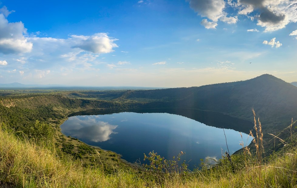
Queen Elizabeth National Park (QENP) is home to over 50 explosion craters. The most accessible are the Katwe Explosion Craters, which offer a 27 km scenic drive beginning near the Katabatoro Gate. This route provides sweeping views
4-days-queen-elizabeth-national-park-and-kyambura-gorge-chimpanzee-tracking
4-days-kibale-forest-chimpanzee-tracking-and-queen-elizabeth-national-park
4-days-bwindi-impenetrable-gorilla-trekking-and-queen-elizabeth-park-tour
4-days-best-gorilla-trekking-and-safari-in-uganda-lake-mburo-national-park
4-days-queen-elizabeth-park-semuliki-national-park-uganda-safari-tour
4-days-gorilla-trekking-lake-bunyonyi-and-kalinzu-forest-chimpanzee-tracking
4-days-budget-queen-elizabeth-park-and-chimpanzee-tracking-in-kalinzu-forest
4-days-luxury-gorilla-trekking-safari-in-bwindi-fly-in-all-inclusive-tour
4-days-queen-elizabeth-park-and-lake-mburo-uganda-safari-tour
3-days-trips-to-queen-elizabeth-national-park-for-chimpanzee-tracking-in-kyambura-gorge
3-days-uganda-safari-itinerary-to-queen-elizabeth-national-park
3-days-budget-queen-elizabeth-park-uganda-wildlife-safari-holiday
2-days-affordable-budget-uganda-safari-to-queen-elizabeth-national-park
2-days-quick-escape-to-queen-elizabeth-park-safari-holiday
f the Rwenzori Mountains and Lake Katwe, where local salt panning takes place.
Bunyaruguru Crater Fields
The Bunyaruguru Crater Fields offer a truly dramatic volcanic landscape that clings to the Kichwamba escarpment on the edge of Queen Elizabeth National Park. This incredible region features over 20 unique volcanic craters, formed by massive tectonic shifts thousands of years ago. As you drive up the escarpment, the sudden change in altitude treats you to breathtaking, sweeping views where lush, green hillsides plunge straight down into the wide-open savannahs of the Albertine Rift Valley.
Among these lakes, Lake Nkugute is easily the most famous and accessible. Right along the paved Mbarara-Kasese Highway, this deep, dark-blue water body requires absolutely no strenuous hiking to see—you can admire it right from your car window. Interestingly, from a bird's-eye view, the lake is shaped remarkably like a human map of Africa. It drops to depths of over 50 meters and is wrapped in fascinating local legends shared by the Banyaruguru people, who have farmed these hills for generations.
The local community has completely intertwined their daily lives with this rugged terrain. Thanks to the mineral-rich volcanic soil and an average annual rainfall exceeding 1,200 millimeters, Bunyaruguru is a bustling agricultural paradise. As you travel through, you will see endless terraced farms of matooke (green bananas), coffee, and tea blanketing the steep crater rims. This area provides a beautiful, refreshing transition from the hot wildlife plains below to the cool, mist-covered highlands, showcasing Uganda's raw geological beauty.
The Katwe Craters
Tucked into the northern sector of Queen Elizabeth National Park near the Mweya Peninsula, the Katwe Crater Fields feel like a step onto another planet. This area is defined by a cluster of extinct volcanic cones and hyper-saline crater lakes that stand out sharply against the surrounding grassy plains. Unlike the freshwater lakes nearby, Katwe's waters are heavily concentrated with intense minerals, creating a unique environment that supports both a historic human industry and specialized wildlife.
Lake Katwe itself is the lifeblood of the local community. For over 600 years, local salt miners have used traditional methods to harvest salt from its shallow, super-salty waters. The lake bed is a fascinating grid of more than 1,000 individually owned salt pans, separated by narrow wooden walkways and mud walls. Miners work under an intense sun, scraping up rock salt and letting the briny water evaporate to collect high-grade edible salt. This grueling process is the primary livelihood for over 3,000 residents of Katwe village, who still do everything completely by hand without modern machinery.
For birdwatchers and nature lovers, the neighboring salt lakes—especially Lake Munyanyange—offer an unforgettable show. The high salt content creates a buffet of specialized algae and tiny water insects, making the lake a top-tier feeding ground for migratory birds. Most notably, between October and April, thousands of lesser and greater flamingos gather here, turning the water's edge into a vibrant sea of pink. Watching these elegant birds feed in the shadow of an ancient volcanic crater, with traditional miners working just a stone's throw away, is a rare and beautiful glimpse of nature and human history living side by side.
Ndali-Kasenda Crater Fields
Located just north of Queen Elizabeth National Park and a scenic 2-hour drive from the Mweya Peninsula, the Ndali-Kasenda Crater Fields form one of the densest and most striking volcanic landscapes in East Africa. Situated near Fort Portal and bordering the chimp-filled forests of Kibale National Park, this sprawling region boasts a jaw-dropping cluster of roughly 60 permanent and seasonal crater lakes. The area is defined by steep, emerald-green ridges that plunge dramatically into pristine waters, making it an absolute dream for hikers, photographers, and wildlife.
The ultimate highlight here is the famous "Top of the World" hike. This guided walk leads you up to a prominent, high-altitude ridge that rewards you with a panoramic, 360-degree view of the entire landscape. From this single spot, you can look down upon 3 to 4 distinct crater lakes at the exact same time, while the majestic Rwenzori Mountains tower in the western distance. Among these lakes is Lake Nyinambuga, a body of water so picture-perfect that its image was proudly featured on Uganda's old 20,000-shilling currency note. Another gem is the Lake Nkuruba Nature Reserve, where the lush forest canopy is home to playful, endangered red colobus and black-and-white colobus monkeys.
The Ndali-Kasenda region is highly celebrated for its welcoming eco-tourism vibe and outdoor adventures. Unlike the harsh, salty waters of Katwe, many of the craters here are filled with clean, fresh water that is completely safe for swimming, as they are free from bilharzia, hippos, and crocodiles. You can easily spend days walking along the crater rims, paddling a canoe across the calm waters, or touring local vanilla and organic coffee farms. It serves as the perfect, relaxing bridge between a classic savannah safari and a chimpanzee trekking adventure.
Which crater lakes contain the famous ancient salt mines?
The ancient, hand-harvested salt mines are located exclusively within Lake Katwe, which sits inside the Katwe-Kikorongo crater field in the northern sector of Queen Elizabeth National Park. This hyper-saline lake occupies the floor of an extinct volcanic caldera. For over 600 years, local families have extracted rock salt from its briny waters using traditional methods that have remained virtually unchanged since the 14th century.
The lake bed is uniquely divided into a complex grid of more than 1,000 individually owned salt pans, bordered by mud berms and wooden walkways. Miners work under scorching equatorial temperatures to scrape salt crusts from the bottom of these shallow pans, allowing the sun to naturally evaporate the intense brine. This fascinating, labor-intensive industry is the primary source of income for over 3,000 residents of Katwe village. Because the lake's extreme salinity prevents any fish or aquatic plants from surviving, it exists purely as a historic industrial hub and a brilliant testament to human endurance and cultural heritage.
Are there any dangerous animals swimming in the water?
Whether you encounter dangerous wildlife depends entirely on which specific crater field you are exploring. If you are visiting the saline lakes within the Katwe Crater Fields—such as Lake Katwe or Lake Munyanyange—the water is far too salty and toxic for large aquatic animals to survive. You will never find large mammals like hippos or crocodiles swimming in these mineral-heavy calderas, making them completely safe from large predators, though the water itself is not suitable for swimming.
Conversely, the story changes beautifully when you head into the freshwater paradises of the Ndali-Kasenda Crater Fields near Fort Portal. Many of these deep, clear lakes—such as Lake Nkuruba or Lake Nyinambuga—are celebrated for being 100% free from crocodiles, hippos, and bilharzia parasites. This makes them safe, refreshing havens for travelers looking to swim, kayak, or canoe. However, always double-check with a local guide before jumping into any crater lake, as neighboring open water bodies connected to the main savannah rivers, like the Kazinga Channel, are heavily populated by thousands of hippos and massive Nile crocodiles.
How many unique crater lakes surround the national park?
The volcanic landscape hugging Queen Elizabeth National Park is incredibly dense, boasting a collective total of over 80 unique volcanic craters and crater lakes split across three primary fields. This concentration makes the Albertine Rift Valley region one of the most volcanically active looking landscapes in East Africa, shaped by dramatic tectonic forces that ruptured the earth's crust thousands of years ago.
When you break down the geography, the Ndali-Kasenda field to the north is the largest cluster, packing roughly 60 permanent and seasonal lakes into a single, emerald-green network. Further south, along the western boundary of the park, the Bunyaruguru field adds another 20+ craters to the tally, including the famously accessible Lake Nkugute. Finally, the Katwe field near the Mweya Peninsula features a smaller but highly dramatic cluster of about 8 main volcanic depressions. Together, these scores of craters create a jaw-dropping topography of alternating mirror-like waters and steep, forested ridges that perfectly frame the surrounding African savannah.
When is the best time for a scenic crater drive?
The absolute best time to embark on a scenic crater drive is during the region's dry seasons, which run from June to September and December to February. During these months, rainfall is minimal, ensuring that the steep, unpaved dirt tracks tracing the crater rims remain dry, firm, and fully navigable for 4x4 safari vehicles. Clear, sunny skies dominate the weather, giving you the crispest, most unobstructed views of the deep-blue waters contrasting against the vibrant green landscapes.
Furthermore, the dry seasons offer the ultimate conditions for landscape photography and wildlife viewing. With less moisture in the air, visibility stretches for miles, allowing you to clearly see the dramatic silhouette of the Rwenzori Mountains rising in the background. If your crater drive includes the salt lakes of Katwe, the dry months are also peak salt harvesting season, meaning you'll see hundreds of local miners actively working the salt pans. For avid birdwatchers, a mini-window between October and April is also spectacular, as migratory birds arrive in massive numbers.
Which crater lakes are the best for viewing flamingos?
The absolute premier destination for viewing flamingos is Lake Munyanyange, a shallow, highly saline crater lake located just outside the town of Katwe, near the northern borders of Queen Elizabeth National Park. This unique lake doesn't support fish, but its mineral-rich, warm waters create a perfect breeding ground for microscopic blue-green algae, brine shrimp, and specialized macro-invertebrates—the absolute favorite diet of these elegant wading birds.
Between the months of October and April, Lake Munyanyange transforms into a stunning wildlife spectacle as thousands of migratory lesser and greater flamingos congregate along its muddy shoreline. The birds fly in from as far away as Kenya's Lake Nakuru and Lake Natron in Tanzania, painting the edges of the water in a brilliant, undulating wave of pink. Because the lake is easily accessible by a short walking trail, birdwatchers can get relatively close to the flocks without disturbing them. It serves as an essential sanctuary, hosting over 100 species of waterbirds, including plovers, gulls, and terns.
Can you hike around the Bunyaruguru crater field rim?
Yes, hiking around the rims of the Bunyaruguru Crater Fields is an incredible experience for active travelers. Situated on the steep Kichwamba escarpment, this field offers several community-led trails that wind along the high ridges of its 20+ volcanic craters. The paths take you through a vibrant tapestry of local life, guiding you past small homesteads and beautifully terraced farms growing matooke (green bananas), vanilla, and organic coffee.
A favorite route for hikers is the trail overlooking Lake Nkugute, the deep crater lake famously shaped like the map of Africa. Walking the elevated rim rewards you with a dramatic, double-sided perspective: looking inland, you gaze down into the quiet, mist-shrouded waters of the crater, while looking outward reveals a drop-off into the vast, sun-drenched savannahs of Queen Elizabeth National Park below. These hikes typically last anywhere from 1 to 3 hours and feature moderate inclines, making them an excellent way to stretch your legs, interact with welcoming local farmers, and take in some of western Uganda’s finest views.
How were the explosive volcanic craters originally formed?
The dramatic craters found throughout western Uganda were formed relatively recently in geological terms, during a period of violent volcanic activity roughly 8,000 to 10,000 years ago. These are not traditional, cone-shaped volcanoes that oozed molten lava. Instead, they are known as explosion craters or maars, which were created by incredibly violent, super-heated underground explosions.
The process began during the formation of the Great Rift Valley, when deep cracks in the earth allowed rising volcanic magma to come into direct contact with shallow underground water tables. This meeting caused the water to instantly flash into high-pressure steam. With nowhere to expand, the trapped steam built up immense pressure until it violently blasted through the earth's surface, blowing rock, ash, and debris thousands of feet into the air. This explosive force left behind deep, circular calderas with steep walls. Over thousands of years, heavy tropical rainfall and natural underground springs filled these hollow depressions, transforming the ancient blast zones into the stunning freshwater and saline lakes we see today.
Which lakes offer the closest views of Rwenzori Mountains?
The Ndali-Kasenda Crater Fields, located just south of Fort Portal, offer the absolute closest and most dramatic views of the snow-capped Rwenzori Mountains. Because this cluster of roughly 60 crater lakes sits on an elevated plateau directly at the base of the mountain range's eastern foothills, the towering "Mountains of the Moon" serve as a massive, jagged backdrop to the entire watery landscape.
The absolute best vantage point within this field is the celebrated "Top of the World" viewpoint. Standing on this high ridge, you can look down into the emerald-green waters of Lake Nyinambuga, Lake Nkuruba, and Lake Lyantonde simultaneously, while looking straight ahead to see the sharp, mist-shrouded peaks of the Rwenzoris rising over 5,000 meters into the sky. On a clear morning, the reflection of the rugged mountain ridges dancing across the mirror-like surfaces of the crater lakes creates a dream scenario for landscape photographers, seamlessly blending deep volcanic calderas with alpine heights.
Are local community guides available for crater lake walks?
Yes, local community guides are readily available, and hiring them is highly recommended to get the most out of your crater lake walks. Across the Bunyaruguru, Katwe, and Ndali-Kasenda fields, resident associations have trained passionate young guides who have grown up on these very volcanic slopes. Utilizing their services ensures your tourism dollars directly support local families and eco-tourism initiatives.
Walking with a local guide transforms a simple scenic stroll into a rich cultural immersion. They won't just keep you on the right path; they will share the fascinating centuries-old folklore and creation myths associated with lakes like Nkugute or Nyinambuga. They will point out indigenous bird species, identify traditional medicinal plants hidden in the brush, and introduce you to local farmers working the terraced coffee and matooke plantations. Whether you want a short 1-hour sunset walk or a full-day multi-crater trek, these welcoming guides adapt the pace to your fitness style, making your journey safe, informative, and deeply human.
Which crater lakes are closest to the Mweya Peninsula?
The Katwe Crater Fields are the closest lakes to the Mweya Peninsula, located just a short, scenic drive north of the peninsula's primary safari lodges. Positioned right inside the boundaries of Queen Elizabeth National Park, this volcanic cluster is incredibly convenient to visit, often paired with a morning game drive or a late-afternoon boat cruise along the nearby Kazinga Channel.
The drive from the Mweya Peninsula to the spectacular Katwe Explosion Crater Drive takes roughly 15 to 20 minutes. This loop road takes you along the highest rims of the craters, offering elevated views of the Mweya Peninsula, Lake Edward, and the meandering Kazinga Channel below. Within this immediate cluster, Lake Katwe (the historic salt mining lake) and Lake Munyanyange (the seasonal flamingo sanctuary) are the most accessible. Their close proximity to Mweya means you can easily leave your lodge after breakfast, spend a couple of hours watching flamingos and traditional salt miners, and return in time for a relaxed lunch.
Booking Visit to Crater lakes close to Queen Elizabeth Park with us Roads of Adventure safaris
Booking your crater lakes tour with Roads of Adventure Safaris is incredibly easy. You can jump right onto their homepage to check out awesome options like their popular 3-day Queen Elizabeth National Park safari. Their classic itineraries take you straight through the breathtaking Katwe Explosion Craters, offering stunning views of the Rwenzori Mountains and great wildlife spotting across the Kasenyi Plains. You’ll also get to visit the historic Lake Katwe community to see how families have mined salt for generations. Just reach out to their team directly on their website to lock in your next Ugandan adventure!