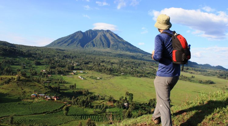
Imagine standing on a jagged peak, catching your breath, and realizing you are simultaneously in Uganda, Rwanda, and the Democratic Republic of the Congo. The Mount Sabinyo hike in Mgahinga Gorilla National Park isn’t just a trek; it’s a rugged, heart-pumping journey across international borders and through prehistoric landscapes. Known locally as "Old Man's Teeth" due to its distinct, deeply eroded serrated peaks, this extinct volcano offers one of East Africa’s most thrilling day hikes.
As you ascend through misty bamboo forests and tackle near-vertical ridges via handmade wooden ladders, you are tracing a living, breathing natural monument. It's a place where rare wildlife thrives, dramatic microclimates shift by the hour, and every grueling step rewards you with unparalleled panoramic views.
1. The Triple-Point Summit: Stand in Three Countries at Once
The ultimate reward of the Mount Sabinyo hike is reaching the unique international triple-point at the summit. At 3,669 meters, the final peak serves as the exact geographical intersection of Uganda, Rwanda, and the Democratic Republic of the Congo. Because there are no physical fences or border walls at this altitude, hikers can freely walk around a marked monument and technically stand in all three nations simultaneously without needing a visa for each.
For example, a hiker can rest their backpack on the Congolese side of the peak, eat lunch while sitting on the Rwandan slope, and look back down the trail toward Uganda. This makes the Mount Sabinyo hike one of the few places on earth where you can experience a multi-national border crossing entirely on foot while surrounded by pristine alpine wilderness. The sense of achievement at the top is amplified by the sheer novelty of navigating three sovereign states in a single step.
2. "Old Man's Teeth": The Origin of the Name
The name of the mountain is deeply rooted in local culture and geology. In the local Kinyarwanda language, the word Iryinyo translates directly to "tooth," and Sabinyo means "Old Man's Teeth." When viewed from a distance—such as from the roads leading into Kisoro town—the mountain’s silhouette does not look like a smooth, symmetrical volcanic cone. Instead, it features a deeply eroded, jagged, and uneven ridgeline.
For example, when the morning mist clears over Mgahinga, the stubby, spaced-out rock formations along the ridge perfectly mimic the worn-down, isolated teeth of an elderly person's jawline. This vivid visual description has passed down through generations of the local Batwa and Bafumbira communities, who used the mountain's distinct shape for navigation long before modern maps were drawn. On the Mount Sabinyo hike, adventurers get to climb right over these geometric "teeth."
3. The Virunga Range's Oldest, Extinct Volcano
Geologically, the Mount Sabinyo hike takes you up the literal foundation of the Virunga volcanic chain. Out of the eight major volcanoes that span the region, Sabinyo is the oldest, estimated to have formed during the early Pleistocene epoch. Unlike neighboring active giants like Mount Nyiragongo and Mount Nyamuragira in the DRC, which still spit lava and ash, Sabinyo has long been dormant and is now classified as strictly extinct.
Because it has not erupted for hundreds of thousands of years, weathering and tectonic forces have had eons to carve deep gorges and sharp ridges into its structure. For instance, while younger volcanoes like Mount Muhavura have relatively smooth, uniform slopes because of recent lava flows, Sabinyo’s heavily weathered crater walls have completely collapsed, leaving behind the rugged, skeletal rock faces that hikers scramble across today.
4. Uganda’s Exclusive Trail
Geographically, the mountain belongs to three nations, but logistically, the Mount Sabinyo hike can only be launched from one. The Uganda Wildlife Authority (UWA) maintains the only viable, managed trail to the summit, starting at the Ntebeko Visitor Center in Mgahinga Gorilla National Park. The topography on the Rwandan and Congolese sides is characterized by sheer, vertical cliffs and unstable, crumbling rock faces that make standard trail construction impossible.
For example, attempts to scout routes from Volcanoes National Park in Rwanda or Virunga National Park in the DRC have consistently been abandoned due to the extreme danger of landslides and impassable drops. As a result, international travelers who want to stand on this specific triple-point must travel to southwestern Uganda to begin their journey, making it a proud centerpiece of Ugandan eco-tourism.
5. Navigating the Hand-Made Wooden Ladders
The Mount Sabinyo hike is famous—and sometimes feared—for its reliance on a network of steep, hand-made wooden ladders. Because the trail follows narrow, knife-edge ridges with sharp drop-offs on either side, walking on open ground is occasionally impossible. To solve this, the Uganda Wildlife Authority secured dozens of rustic wooden ladders directly into the sheer rock faces and vertical mud banks.
For instance, as you approach the final stretch toward Peak Two and Peak Three, you will encounter ladders that are nearly 90 degrees vertical, stretching up tens of meters against the cliffside. Climbing these requires physical upper-body strength and a steady stomach for heights, as a glance to the left or right reveals misty, thousand-foot drops into the gorges below. It turns a standard mountain trek into an exhilarating, full-body scramble.
6. Conquering the Multiple Peaks
A defining characteristic of the Mount Sabinyo hike is its multi-peak structure. The mountain does not have a single apex; rather, the trail challenges hikers to conquer consecutive peaks along the serrated ridge. The full trek is a grueling 8-hour round trip that tests endurance, and hikers have the option to turn back at different intervals depending on their physical condition and weather constraints.
For example, Peak One demands a steep climb through the forest and offers the first major viewpoint. Many hikers choose to stop here if they are fatigued or if afternoon storms are rolling in. To reach the actual triple-point, however, you must push forward past Peak Two—which requires navigating the most intense ladder sections—before making the final push to Peak Three, the official summit where the three borders meet.
7. Defining Uganda’s National Borders
Beyond its natural beauty, Mount Sabinyo holds immense political and legal weight. The mountain is a primary geographic anchor used to establish where Uganda begins and ends. In the official Constitution of the Republic of Uganda, the legal description of the country's sovereign territory explicitly references Sabinyo as a foundational boundary marker.
For example, when international boundary commissions mapped out the region during the colonial era and later reaffirmed it in post-independence legal texts, they used the highest point of Sabinyo as a fixed vertex. The legal borders run in straight lines from this volcanic peak down to neighboring water bodies and ridges, meaning the Mount Sabinyo hike allows you to walk along the literal framework of East African geopolitics.
8. Wildlife on the Slopes: Gorillas and Golden Monkeys
The lower sections of the Mount Sabinyo hike wind through a highly protected, biodiversity-rich sanctuary. Mgahinga Gorilla National Park is famous for hosting habituated families of critically endangered mountain gorillas and rare golden monkeys, both of which rely on the dense bamboo zones at the base of the mountain for food and shelter.
For example, it is not uncommon for hiking groups, accompanied by armed UWA rangers, to spot fresh gorilla nests, discarded bamboo shoots, or even hear the rustling of a gorilla family moving through the undergrowth just a few kilometers from the trailhead. While the hike is focused on reaching the summit rather than tracking wildlife, these early-morning encounters add an unpredictable, thrilling safari element to the mountaineering experience.
9. An Affordable Adventure
Compared to other high-altitude treks or wildlife experiences in East Africa, the Mount Sabinyo hike is remarkably cost-effective. A permit to climb the mountain costs just US $80 for foreign non-residents and 50,000 UGX for East African citizens. Crucially, this fee is inclusive of the daily park entry fee and the mandatory services of armed UWA guiding rangers.
For contrast, a single mountain gorilla trekking permit in the same park costs $800 for foreign non-residents, and climbing larger regional peaks like Mount Kilimanjaro can easily run into thousands of dollars when factoring in mandatory porter crews and multi-day camping fees. This makes the Sabinyo day-hike one of the best value-for-money adventures for budget-conscious travelers looking for a world-class physical challenge.
10 A Journey Through Changing Microclimates
As you ascend during the Mount Sabinyo hike, you witness a rapid, dramatic shift in vegetation zones driven by the changing altitude. The trek functions as a living biology lesson, starting in human-impacted regeneration zones before transitioning into dense, shadowy bamboo forests between 2,000 and 2,500 meters, which is the favorite feeding ground of local primates.
Higher up, the bamboo gives way to the otherworldly Hagenia-Hypericum forest zone. Here, massive, ancient trees are heavily draped in long strands of Usnea—commonly known as "Old Man's Beard" moss—creating an eerie, fairy-tale atmosphere shrouded in mountain mist. Finally, as you break past 3,000 meters, the trees disappear entirely, replacing the dense canopy with an exposed alpine and sub-alpine zone dominated by giant lobelias, groundsels, and hardy everlasting flowers that can survive the freezing night temperatures of the summit.
Here are 10 targeted questions about the trek, each followed by a direct, human-focused breakdown of what to expect on the trail.
Is the Mount Sabinyo hike safe for beginner hikers?
The Mount Sabinyo hike is highly manageable if you possess solid baseline cardio, but it is not a walk in the park for absolute beginners. The trail throws serious elements at you: slick mud, steep drops, and high-altitude air that thins out quickly above 3,000 meters. If you routinely walk long distances or hit the gym, you will handle the physical strain just fine.
Safety on the mountain is tightly managed. Every single trekking group is accompanied by armed Uganda Wildlife Authority rangers who set a sensible, sustainable pace and monitor everyone for signs of exhaustion or altitude sickness. The primary challenge for novices isn't raw endurance; it is dealing with the sheer exposure of the ridgelines. If you are prone to severe vertigo or panic around heights, the narrow trails and vertical drops can feel incredibly intimidating. However, as long as you watch your footing, listen to your guiding ranger, and take regular breaks to catch your breath, you do not need advanced mountaineering experience to complete this trek successfully.
What gear should I pack for this intense trek?
Packing correctly makes or breaks your experience on the Mount Sabinyo hike. The weather on the volcano is notoriously unpredictable; a bright, sunny morning at the Ntebeko visitor center can easily transform into a freezing, torrential downpour by the time you reach the second peak. You need to dress in versatile layers, starting with a moisture-wicking base shirt and topping it with a high-quality waterproof jacket.
Footwear is your most critical choice. Leave your regular running sneakers at home; you absolutely need sturdy hiking boots with deep tread to grip the slippery volcanic mud and wet wooden ladders. Pack a pair of lightweight, durable gardening gloves to protect your hands from splinters and friction while climbing the ladders and grabbing onto rough vegetation. Finally, bring a comfortable backpack containing at least three liters of water, energy-rich snacks like nuts or dried fruit, and a basic personal first-aid kit with blister plasters. Wrapping your spare clothes in a waterproof dry bag inside your pack ensures you have something warm to change into if the heavens open up.
How long does the entire round trip usually take?
On average, the Mount Sabinyo hike takes about eight hours to complete from start to finish. This timeframe includes the steady ascent up all three peaks, a well-deserved break at the summit to enjoy the view and take photos, and the careful descent back down to the park headquarters. However, the exact duration depends heavily on the physical fitness of the group and the prevailing weather conditions on the day.
If you are hiking during the rainy season, the trails turn into slick mud shoots, which naturally slows down your pace as you navigate the tricky terrain safely. The ascent takes up the bulk of the time, usually requiring four to five hours of continuous climbing. While descending might sound easier, it requires intense concentration and significant leg strength to safely navigate the steep steps and ladders backward. The park rangers are excellent at managing the group's time, ensuring everyone moves at a pace that gets the entire team back down the mountain well before the African sun begins to set.
Can children participate in the Mount Sabinyo hike?
The Mount Sabinyo hike is generally not recommended for young children due to its grueling physical demands and inherent geographic hazards. The Uganda Wildlife Authority enforces a strict minimum age limit of 15 years old for this specific trek, which aligns with the age restrictions placed on gorilla tracking within the national park.
The primary reason for this restriction is safety along the high-altitude ridgelines. The handmade wooden ladders require a certain physical height, arm span, and upper-body strength to navigate confidently. A child would struggle to bridge the gaps between the rungs safely. Furthermore, the trail demands intense mental focus for eight hours straight; a single misstep on the narrow ridges can be dangerous. Teenagers who are physically active, comfortable with heights, and accustomed to long-distance walking can handle the challenge well, but for younger family members, the steep gradients and exposed drop-offs present unnecessary risks. The park offers flatter, scenic nature walks along the lower bamboo zones that are far better suited for younger children.
When is the best time of year to climb?
The ideal windows for the Mount Sabinyo hike fall during the region's two distinct dry seasons: from June to August and from December to February. During these months, the weather is significantly more stable, offering clearer skies, spectacular panoramic views across three countries, and much drier, firmer trails underfoot.
Climbing during the dry season makes navigating the notorious wooden ladders vastly easier and less nerve-wracking, as the wood is less slippery and the footholds are clear of mud. That said, because Sabinyo is a tropical montane rainforest environment, rain can fall at any time of year regardless of the season. If you choose to hike during the wet seasons—typically March to May and September to November—you must prepare for heavy downpours, thick mountain mist that can completely obscure the summit views, and incredibly muddy paths that turn the trek into a slippery scramble. The trade-off is that the wet season brings lush, vibrant green landscapes and far fewer tourists on the trails.
Are there porters available to help carry bags?
Yes, hiring a local porter at the Ntebeko Visitor Center before starting the Mount Sabinyo hike is highly recommended. Porters are members of the surrounding local communities, including the Batwa and Bafumbira people, who know the mountain intimately and are exceptionally well-conditioned to the high altitude and steep terrain.
Hiring a porter costs a modest fee—usually around $15 to $20 USD—but it provides immense value. By handing over your heavy backpack containing your water, food, and heavy rain gear, you free your body from unnecessary strain, allowing you to focus entirely on your footing, balance, and breathing as you tackle the steep inclines and vertical ladders. Beyond the physical relief it offers you, hiring a porter is a direct and impactful way to support the local economy. Eco-tourism dollars flow straight into the community through these wages, providing families with vital income and fostering a strong local commitment to protecting the national park and its wildlife.
What happens if it rains during the trek?
If it starts to rain during the Mount Sabinyo hike, the entire dynamic of the trek shifts immediately, requiring extra caution and focus. The park rangers will evaluate the severity of the weather on the spot. If it is a standard tropical shower, the hike continues, and you will need to quickly pull on your waterproof jacket and pack covers to stay dry.
The mud on the trails quickly becomes slick, transforming earthen steps into slides. The handmade wooden ladders become notably slippery, requiring you to slow down significantly, double-check every single handhold, and firmly plant your feet before moving. If the rain is accompanied by severe thunderstorms or heavy lightning, the rangers will prioritize safety and abort the climb, as the exposed rocky peaks and metal-reinforced ladders turn into major hazards. Thick mountain mist often rolls in with the rain, dropping the temperature rapidly and cutting visibility down to a few meters. Staying warm and maintaining a calm, deliberate pace are key to handling a rainy day on Sabinyo.
Is altitude sickness a problem on this mountain?
Altitude sickness can potentially affect anyone on the Mount Sabinyo hike, as the summit reaches a respectable 3,669 meters above sea level. At this elevation, the air pressure drops, meaning there is less oxygen available with every breath you take. It is common to feel your heart rate spike and your breathing become heavy early in the climb.
Most hikers only experience mild symptoms of acclimatization, such as a slight headache, minor dizziness, or feeling fatigued much quicker than usual. The best way to combat this is to follow the classic mountaineering mantra: walk slowly and drink plenty of water throughout the day. The UWA rangers are experts at pacing the group, deliberately keeping the speed slow and steady to give your body time to adjust to the elevation changes. If you start experiencing severe symptoms, such as an intense, throbbing headache, nausea, or loss of physical coordination, you must inform your guide immediately. The only cure for true altitude sickness is to stop ascending and head back down the mountain.
Will I definitely see mountain gorillas on the trail?
While the lower slopes of the volcano run directly through prime primate habitat, you should not expect a guaranteed gorilla encounter during the Mount Sabinyo hike. The primary goal of this trek is peak bagging and mountaineering, not wildlife tracking. Mountain gorillas are wild animals that move constantly through the dense bamboo forest in search of food.
However, because the trail cuts through their natural territory, lucky encounters do happen. You might hear the deep rumble of a silverback in the thickets, spot fresh footprints in the mud, or see discarded bamboo shoots left behind from breakfast. If your group does happen to cross paths with a wild gorilla family, the rangers will immediately enforce strict safety protocols, instructing everyone to keep a quiet, respectful distance of at least ten meters. If your primary dream is to spend an hour looking directly into the eyes of a mountain gorilla, you should book a dedicated gorilla trekking permit in Mgahinga or Bwindi, where trackers actively locate the habituated families beforehand.
How do I book a permit for Sabinyo?
Booking a permit for the Mount Sabinyo hike is a straightforward process compared to the highly competitive wildlife viewing permits in the region. You can secure your hiking permit directly through the Uganda Wildlife Authority (UWA) booking office in Kampala, or more conveniently, buy it in person right at the Mgahinga Gorilla National Park headquarters in Ntebeko on the morning of your trek.
Because the mountain does not have strict daily caps on hiker numbers like the gorilla tracking groups do, permits rarely sell out, giving you excellent flexibility with your travel itinerary. The permit fee stands at $80 USD for foreign non-residents and 50,000 UGX for East African citizens, covering your park entry, community fees, and ranger guides. Many travelers prefer to coordinate the booking through a local Ugandan tour operator, who can bundle the permit together with your transport from Kisoro town, local accommodation, and porter arrangements, ensuring a completely seamless, stress-free arrival at the trailhead.
Booking Mountain Sabinyo hike with us Roads of Adventure safaris
Booking your Mount Sabinyo hike with Roads of Adventure Safaris turns a rugged, high-altitude expedition into a smooth, seamless journey. Starting at the Ntebeko Park Headquarters in Mgahinga, this challenging 8-hour trek pushes you up steep, misty ridges and vertical wooden ladders to a spectacular 3,645-meter summit. Standing at the top means planting your feet in Uganda, Rwanda, and the DRC all at once. Because permits cost around $80 to $100 and mountain weather is highly unpredictable, coordinating with their team a few weeks in advance ensures your guides, entry, and logistics are perfectly locked in for the climb.