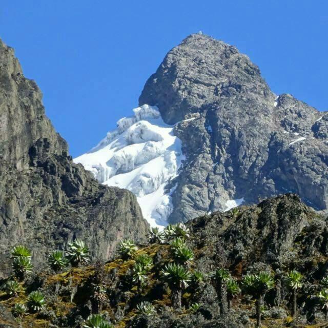
Trekking the Rwenzoris over 10 days is an unforgettable, wild adventure—one that demands both solid stamina and mental grit.
Starting at Nyakalengija, you'll register, gear up, and head out through lush rainforests and local farmlands. As you push higher, the trail leads through five dramatic vegetation zones, taking you from the tricky, mud-hopping Bigo Bog to surreal landscapes filled with giant lobelias. Nights are spent in cozy, basic wooden huts like Nyabitaba and Elena to shelter from the freezing cold.
The journey hits its stride around the steep Scott-Elliot Pass (4,541m). On summit day, a midnight start, crampons, and ropes help you conquer the icy Margherita Peak (5,109m). Expect unpredictable rain, icy winds, and altitude shifts, but as you descend through lush valleys, the sheer reward of taking on the "Mountains of the Moon" makes every single step worth it.
1. Overview & Physical Preparation
Trekking Africa’s third-highest peak is an extraordinary adventure, but it demands serious physical stamina and mental toughness. Unlike standard high-altitude treks where established trails offer smooth footing, the Rwenzoris present raw, technical terrain. Over ten days, you will journey through five distinct vegetation zones—transitioning from dense tropical rainforests to glacier-capped alpine summits.
The physical challenge is continuous. You will navigate steep, root-choked trails, balance on wet wooden boardwalks, and hike through deep, thick mud. As you cross into high-altitude zones, the air thins significantly, making every incline feel double its actual steepness. Daytime conditions can range from warm, humid rainforest air to freezing rains and icy winds near the top. Mentally, you must prepare for long, grueling days on your feet, damp gear, and simple living conditions in remote wilderness huts.
Successful climbers maintain a steady, unhurried pace ("pole pole") to conserve energy and give their bodies time to adapt to the rising elevation. Building strong cardiovascular endurance, leg strength, and mental resilience before you arrive ensures that when the physical grind kicks in, you can stay focused and enjoy one of the world's most dramatic mountain landscapes.
2. Park Registration and Briefing
Your expedition officially begins at the Rwenzori Mountaineering Services (RMS) headquarters in Nyakalengija, situated at an elevation of 1,646 meters (5,400 feet). This initial stop sets the tone for the entire journey. Here, you will complete mandatory park registration with the Uganda Wildlife Authority (UWA) before meeting the local team that will support you—your lead mountain guides, assistant guides, cook, and porters.
Before setting foot on the trail, your gear undergoes a thorough check. Your guides inspect critical equipment, including your waterproof jackets, thermal layers, sturdy trekking boots, and specialized mountaineering gear like harnesses, crampons, and ice axes. If you are missing essential items, this is your last opportunity to rent them at the base camp.
During the safety briefing, your lead guide will outline the itinerary, daily trekking expectations, altitude safety protocols, and leave-no-trace wilderness guidelines. You will also organize your luggage: main gear is packed into heavy-duty duffel bags for the porters to carry (typically weight-capped around 15 kg per climber), while you keep a lightweight daypack with your water, extra layers, rain gear, and personal snacks. Once the gear is distributed and final checks are complete, you set off into the foothills of the "Mountains of the Moon."
3. Dense Rainforest and Farmlands
The opening stage of your trek introduces you to the vibrant lower slopes of the Rwenzori range. Leaving the trailhead, you first wander through the rolling farmlands of the Bakonjo people, the native inhabitants who have lived alongside these mountains for centuries. The cultivated fields soon yield to tall elephant grass, thick bamboo thickets, and dense podocarpus forests along the rushing waters of the Mubuku and Mahoma rivers.
This lower zone is rich in biodiversity and full of life. As you climb the steep, winding foothills, keep your eyes open for black-and-white colobus monkeys, blue monkeys, and colorful bird species like the Rwenzori Turaco. You might even spot the rare three-horned chameleon basking on branches along the path.
While lower in elevation, these early days are far from a casual walk. The humidity is high, and the trail consists of steep, root-covered terrain that requires careful foot placement. Crossing the rivers involves navigating slippery, moss-covered rocks or sturdy wooden footbridges suspended over churning mountain waters. It serves as an ideal warmup, letting your legs get used to the steep inclines while you absorb the sights and sounds of one of East Africa’s most pristine equatorial rainforests.
4. The Infamous Bigo Bog
As you cross the 3,000-meter mark, the rainforest gives way to one of the most famous and physically demanding obstacles on the mountain: the Bigo Bog. Spanning a broad valley floor surrounded by towering cliffs, this massive wetland is a wetland terrain of deep peat, moss, and tussock grass soaked by near-constant rainfall.
Historically, trekking through the Bigo Bog meant sinking waist-deep into thick, cold mud with almost every step. Today, the park service has installed long stretches of raised wooden boardwalks over the swampiest sections. Walking these timber planks makes the journey faster and protects the delicate bog ecosystem from erosion, but it requires continuous balance and concentration, as the wooden surfaces are frequently wet and slippery.
Where boardwalks end, traditional bog-hopping begins. You must jump from one tussock—a firm mound of roots and sedge grass—to the next, careful not to lose your balance and slip into the cold mud below. Trekking poles are essential here for testing depth and maintaining stability. The effort is tiring and tests your core stability, but the landscape is uniquely breathtaking: shrouded in mist, carpeted in lush mosses, and completely separated from the outside world.
5. Giant Heather and Lobelia Zones
Higher up the trail, between 3,000 and 4,000 meters, the landscape undergoes a remarkable transformation into an alpine wonderland. This is the giant heather and lobelia zone, an ecosystem characterized by flora that grows to extraordinary sizes due to high humidity, constant mist, and unique equatorial lighting.
You will trek beneath giant heather trees (Erica arborea) draped in long streamers of beard moss, creating a ancient, forest setting. Emerging into open moorland, you are surrounded by giant lobelias—towering, column-like plants that collect rainwater in their central rosettes—and giant groundsels (Senecio), which look like prehistoric palm trees topped with thick, leathery leaves designed to endure freezing night temperatures.
Walking through this terrain feels like stepping onto another planet or back in time. The air grows noticeably cooler and thinner, and clouds frequently drift through the vegetation, creating a quiet atmosphere. The trail here alternates between rocky ridges, boggy depressions, and steep ascents over giant roots. Taking a slow, steady pace allows you to take in these unique plants, which are found in only a few high-mountain ranges across East Africa.
6. High-Altitude Mountain Huts
Throughout your 10-day circuit, you will spend your nights in basic but essential mountain huts located at key points along the route, such as Nyabitaba (2,651m), John Matte (3,505m), Bujuku (3,962m), and Elena (4,541m). These huts provide crucial shelter from the freezing temperatures, heavy rains, and strong winds that sweep across the high peaks every night.
The accommodations are wooden or metal structures fitted with basic bunk beds and thin foam mattresses. There are no luxury amenities: heating is minimal, electricity is limited or non-existent, and bathroom facilities consist of simple mountain drop toilets nearby. Despite their simplicity, reaching a hut at the end of a long, wet day feels like a major relief.
Inside, the atmosphere is cozy and warm with camaraderie. Guides, porters, and trekkers gather in the communal dining spaces to dry wet gear, share hot tea, and enjoy hearty meals cooked by the expedition chef. After dinner, the focus turns to resting and staying warm; high-rated sleeping bags (rated to at least -10°C/14°F), thermal base layers, and warm wool beanies are essential for getting good sleep before the next morning's early start.
7. Understanding Altitude Sickness
Rapidly ascending from the valley floor to altitudes above 3,500 meters subjects your body to decreasing atmospheric pressure and lower oxygen levels. Acute Mountain Sickness (AMS) is a real consideration on the Rwenzoris, and managing it requires awareness and discipline throughout the expedition.
Early symptoms of AMS include mild headaches, light nausea, fatigue, dizziness, and loss of appetite. These are clear signs from your body that it needs time to adapt. To mitigate altitude sickness, your itinerary includes gradual ascent profiles, but the primary defense is moving at a slow, deliberate pace ("pole pole"), drinking 4 to 5 liters of water daily, and eating high-carbohydrate meals to keep your energy up.
Your lead guide will monitor your health closely, checking your blood oxygen levels and heart rate with a pulse oximeter every morning and evening. It is vital to communicate open and honest feedback about how you feel; hiding symptoms can lead to more severe conditions like High Altitude Pulmonary Edema (HAPE) or High-Altitude Cerebral Edema (HACE). If severe symptoms persist, the only reliable cure is descending to a lower altitude, which the guides will arrange immediately to ensure your safety.
8. Scott-Elliot Pass
The Scott-Elliot Pass, sitting at an elevation of 4,541 meters (14,900 feet), is one of the highest and most scenic mountain passes on the traditional Central Circuit. Crossing this steep, rocky saddle connects the upper Bujuku Valley to the Kitandara Lakes and provides panoramic views of the surrounding peaks.
The climb up to the pass is physically taxing. You trek through a rugged field of loose scree, steep boulders, and exposed rock ledges. The high altitude makes every step deliberate, requiring steady footing and rhythmic breathing. As you approach the top, the vegetation thins out completely, leaving a raw landscape of stone, ice, and alpine air.
Reaching the top of Scott-Elliot Pass brings an immense sense of accomplishment. On clear days, the pass delivers views down into the Bujuku Valley, with its glacial lakes shining below, framed by the sheer faces of Mount Speke, Mount Baker, and Mount Stanley. It is a prime location for photos, a quick energy snack, and a moment to take in the sheer scale of the Rwenzori range before continuing your trek.
9. Summit Push to Margherita Peak
For those aiming for Mount Stanley’s highest point—Margherita Peak at 5,109 meters (16,762 feet)—summit day is the technical and physical climax of the trip. The attempt begins around midnight at Elena Hut (4,541m). Waking up in the dark, you pull on cold-weather gear, strap on headlamps, and step out into freezing temperatures to begin the ascent over slick, steep granite slabs.
As you reach the snowline, you put on your harness, crampons, and rope up with your guide. The summit route requires negotiating real glaciers, crossing crevasses, and scaling steep snow slopes. Near the top, you face a fixed-rope climb up an exposed rocky ridge where ice axes and carabiners are necessary to secure your footing.
Reaching Margherita Peak as the sun rises over the clouds is an incredible moment. Standing on the third-highest point in Africa, surrounded by ancient equatorial glaciers and sweeping views into both Uganda and the Democratic Republic of Congo, makes every hour of exertion worth it. After briefly celebrating at the peak, you begin the careful, focused descent back down the ice and rock to safer, lower elevations.
10. Weather, Gear, and Descent
The Rwenzoris are famously wet and icy. The mountain range generates its own weather microclimates, meaning heavy rain, dense fog, snow, and freezing winds can sweep in with little warning on any given day. Navigating deep mud and wet terrain is standard procedure, making top-tier waterproof gear (GORE-TEX jackets and pants), gaiters, waterproof boots, and thermal layers non-negotiable. Keeping a change of clothes completely dry in waterproof dry-sacks inside your pack is crucial for staying warm at camp.
The final days of the expedition involve a long descent down through the scenic Nyamwamba or Bujuku valleys back toward the trailhead at Nyakalengija. While climbing tests your heart and lungs, descending tests your knees, quads, and ankles as you navigate steep, muddy drops, slippery boardwalks, and loose rock.
As you drop back down through the vegetation zones, the icy air gradually gives way to warmer rainforest breezes, rich oxygen levels, and lush greenery. Reaching the RMS headquarters at the base marks the official conclusion of your journey. Tired but triumphant, you leave with a deep appreciation for one of the most rugged, beautiful, and challenging mountain ranges on Earth.
10 Days mountain Rwenzori climbing tour
This extraordinary 10-day expedition takes you deep into the heart of Uganda's wilderness, challenging you with diverse terrains ranging from equatorial rainforests and bamboo zones to otherworldly glacial peaks. As you ascend toward the clouds, you will traverse steep ridges, navigate vibrant bogs, and wake up to sweeping vistas of the Albertine Rift. Every step brings you closer to the breathtaking summit of Margherita Peak, sitting at an elevation of 5,109 meters. Designed for true adventurers, this meticulously crafted itinerary blends physical endurance with unparalleled wilderness immersion, offering a profound experience of nature's untouched beauty and rewarding you with a profound sense of achievement.
Day 1: Arrival & Briefing
Welcome to the Rwenzori region! Your adventure begins as you arrive at the park base in Kasese, the perfect launching pad for your expedition. You will head to the Rwenzori Mountaineering Services offices to meet your expert guides, receive a thorough safety briefing, and ensure all your climbing gear is perfectly fitted. Spend the afternoon resting and preparing your daypack for the grueling days ahead.
Day 2: Nyakalengija to Nyabitaba Hut
Your first day of trekking starts at 1,646 meters, taking you through local farmlands and dense elephant grass before entering the equatorial forest. You will cross the roaring Mahoma River and ascend steeply onto a massive ridge to reach Nyabitaba Hut at 2,652 meters. The 7-kilometer trek takes 4 to 6 hours, offering the first real taste of the mountain's vibrant biodiversity and perhaps a glimpse of playful monkeys or the colorful Rwenzori turaco
Day 3: Nyabitaba to John Matte Hut
Today’s 7-kilometer trek drops steeply to the Kurt Shafer Bridge below the confluence of the Mubuku and Bujuku rivers. You will then hike through a dense bamboo forest before emerging into the surreal zone of giant heather and giant lobelias. After crossing a notoriously tiring bog, you will arrive at John Matte Hut at 3,505 meters. This 6-hour hike is a fantastic test of endurance as the temperature begins to drop significantly.
Day 4: John Matte to Bujuku Hut
Prepare for a challenging but visually stunning 6-hour ascent of about 6 kilometers. You will cross the grueling Bigo Bog, navigating through surreal giant groundsels, before entering the stunning Bujuku Valley. This valley is flanked by Mount Baker and Mount Speke. You will reach Bujuku Hut at 3,962 meters, a crucial acclimatization point perfectly positioned by the serene Bujuku Lake beneath towering, jagged rock faces.
Day 5: Bujuku to Elena Hut
Leaving Bujuku behind, the trail takes you through a breathtaking landscape of deep mud and beautiful vegetation before climbing steeply through a narrow pass to the Scott Elliot Pass at 4,372 meters. From here, you will hike to Elena Hut at 4,541 meters, perched on the rocky outcrop just below the Stanley Glacier. This short but steep 3-hour climb is crucial for acclimatizing before attempting the ultimate summit.
Day 6: Margherita Peak to Kitandara Hut
Today is the ultimate challenge! You will wake up around 2:00 AM to tackle the Stanley Glacier. Using crampons and ropes, you will ascend steep, icy slopes to reach Margherita Peak, the highest point in the Rwenzoris at 5,109 meters. After taking in the panoramic views, you will descend to the beautiful Kitandara Hut at 4,027 meters for a well-deserved rest.
Day 7: Kitandara to Guy Yeoman Hut
After a demanding summit day, you will take on a steady, steep ascent to Fresh Field Pass at 4,280 meters. From this vantage point, you can gaze out into the Democratic Republic of Congo and admire Mount Stanley. The trail then winds down through rocky areas and giant heather to the scenic Guy Yeoman Hut, sitting beside the Mobuku River at 3,505 meters, where you will relax surrounded by stunning waterfalls.
Day 8: Guy Yeoman to Nyabitaba Hut
Today involves descending through the lower altitude zones, making your trek much easier on the lungs but tough on the knees. You will hike through the bamboo forest, crossing several cascading streams and enjoying the lush, green scenery. After 5 to 6 hours of trekking, you will return to the familiar comfort of Nyabitaba Hut at 2,652 meters, where you can reflect on your incredible high-altitude journey.
Day 9: Nyabitaba to Base Camp & Kasese
Your final morning on the trail begins with a steep descent through the lower montane forest to the park headquarters at Nyakalengija. Once you arrive, you will receive your well-earned summit certificates! Afterward, you will transfer back to your lodge in Kasese or Fort Portal to celebrate your massive accomplishment with a hot shower, a warm meal, and a good night's sleep.
Day 10: Departure
Enjoy a relaxed morning reflecting on your monumental achievement. Depending on your travel plans, you will either catch a flight back home or continue your Ugandan adventure to explore nearby savannah parks or spot the famous tree-climbing lions.
Here are 10 key questions and detailed, humanized answers to help you prepare for the ultimate Rwenzori expedition.
How physically fit do I need to be?
Trekking the Rwenzoris is a serious endurance challenge that demands top-tier physical conditioning. Unlike standardized dirt trails, this route forces you to scramble over slippery tree roots, balance on narrow timber boardwalks, and trek through thick, shoe-sucking mud. As you climb past 3,500 meters, the thinning air makes every step feel twice as heavy, putting continuous strain on your lungs and legs.
To enjoy the experience safely, focus your prep work on strong cardiovascular endurance and leg strength. Months before your trip, incorporate long distance hikes with a weighted backpack, hill repetitions, stair climbing, and core stability exercises. Building physical resilience ensures you can handle six to eight hours of daily trekking while keeping your footing secure on wet, uneven terrain. Equal parts mental grit are required when weather turns cold and rainy, so coming mentally prepared for tough days makes all the difference.
What gear is essential for the summit push?
Summitting Margherita Peak requires technical glacier gear alongside serious alpine cold-weather layers. You will need high-altitude mountaineering boots compatible with strap-on crampons, a climbing harness, safety carabiners, and an ice axe. Because the summit push begins around midnight in freezing temperatures, a reliable headlamp with extra batteries is critical for navigating dark, slick granite slabs.
Layering is key to staying safe on the ice. Pack synthetic or merino wool base layers, a warm fleece or down jacket, and a heavy-duty GORE-TEX waterproof shell to block biting winds. Waterproof, insulated gloves are non-negotiable to protect your hands while holding cold metal gear and ropes. You will also need UV-blocking glacier sunglasses to protect your eyes from intense solar glare off the snow. Most technical gear like crampons and harnesses can be rented at the base camp, but bringing well-fitting, pre-tested personal layers ensures maximum comfort.
How do I handle altitude sickness on the trail?
Managing altitude sickness comes down to moving slowly, staying hydrated, and listening closely to your body. As you ascend into thin air, your main mantra should be "pole pole"—Swahili for "slowly, slowly." Pace yourself, even on gentle inclines, to keep your heart rate steady and allow your cardiovascular system time to adjust. Drink four to five liters of water daily, as high-altitude air dehydrates you quickly and worsens mountain sickness symptoms.
Pay attention to early warning signs like mild headaches, light nausea, fatigue, or loss of appetite. Communicate honestly with your guides during their daily health checks; they monitor your oxygen levels with pulse oximeters every morning and night. Packing preventive medication like Diamox can help speed up acclimatization, but if severe symptoms like persistent vomiting or confusion set in, descending to a lower altitude is the only safe solution.
What are the mountain huts actually like inside?
The mountain huts offer basic, rustic shelter that feels like luxury after a long day in the cold rain. Structures like Nyabitaba, John Matte, Bujuku, and Elena are simple wooden or metal cabins designed to shield you from heavy downpours, howling winds, and freezing night temperatures. Inside, you will find communal sleeping rooms with wooden bunk beds topped with basic foam mattresses—there are no private rooms or hotel amenities here.
The heart of each camp is the dining space, where guides, porters, and climbers gather to dry out damp clothing, sip hot tea, and share hearty meals cooked by the trail crew. Bathroom facilities consist of basic outdoor pit latrines, and electricity is extremely limited or non-existent, so bring solar power banks for your electronics. Because nights get bitterly cold, bringing a heavy-duty sleeping bag rated to at least -10°C (14°F) is essential for getting a good night’s rest.
How bad is the mud on the Bigo Bog?
The mud in the Bigo Bog is legendary, but modern trail improvements make it much easier to navigate than in the past. Spanning a broad, mist-shrouded valley, this wetland features deep peat moss soaked by frequent mountain rains. In earlier years, trekkers had no choice but to wade through waist-deep mud. Today, the park service has built long stretches of raised wooden boardwalks across the swampiest sections, making passage faster and protecting the delicate ecosystem.
Where the boardwalks end, traditional "bog-hopping" begins. You will jump from one raised tussock of roots and grass to the next, testing your balance and core strength. Slipping off a tussock means stepping into deep, cold mud, so waterproof gaiters and sturdy waterproof boots are absolute must-haves. Trekking poles are incredibly helpful here for testing mud depth and keeping your balance as you cross this otherworldly landscape.
What kind of weather should I expect daily?
Expect wet, cold, and rapidly changing conditions almost every single day. The Rwenzori range creates its own microclimate, meaning blue skies can turn into heavy rain, dense fog, or sleet within minutes. Lower elevation rainforests are humid and warm, but as you climb higher, temperatures drop sharply, hovering near freezing at the high camps and dipping well below freezing on the glaciers.
Rain is a constant reality on the "Mountains of the Moon," making high-quality waterproof gear your best friend. A breathable GORE-TEX jacket and rain pants, along with waterproof dry-sacks inside your backpack, keep your essential clothing dry. Staying warm depends entirely on staying dry: once your gear gets soaked, the biting wind can chill you quickly. Embrace the dampness as part of the raw adventure, and always keep a fresh, dry set of thermal base layers packed away strictly for sleeping inside the huts.
How much weight do porters carry for me?
Porters carry the vast majority of your heavy gear, allowing you to trek with just a lightweight daypack. Each climber is assigned porters who carry up to 15 kilograms (33 pounds) of your personal equipment in a durable, waterproof duffel bag. They carry your heavy sleeping bag, extra clothing, summit gear, and personal toiletries from hut to hut, often arriving ahead of you to set up camp.
Your job is simply to carry a comfortable 20 to 30-liter daypack containing items you need during the walk. This includes two to three liters of water, rain gear, warm mid-layers, trail snacks, a small first-aid kit, and your camera. Keeping your daypack light saves valuable energy on steep ascents, while relying on the incredible strength and hard work of the local porter team makes navigating the tough terrain possible.
What wildlife will I see along the climb?
The lower and middle zones of the Rwenzoris are teeming with unique wildlife adapted to the equatorial rainforest. During the first few days, you will hear the loud calls of black-and-white colobus monkeys and blue monkeys swinging through the dense canopy. Birdwatchers are in for a treat, with opportunities to spot bright endemics like the famous Rwenzori Turaco, solar-powered sunbirds, and various mountain hornbills.
Keep your eyes on the branches along the trail for the rare three-horned chameleon, a striking reptile unique to these high-altitude forests. While larger mammals like forest elephants, buffaloes, and chimpanzees inhabit the park's lower reaches, they are elusive and rarely seen near active trekking paths. Higher up in the giant lobelia zones, animal life thins out, leaving behind high-altitude birds, small rodents, and a quiet, prehistoric wilderness.
Is technical climbing experience necessary for Margherita?
Prior technical ice climbing experience is not strictly required, but basic scramble skills and good physical coordination are essential. The ascent up Margherita Peak involves navigating active glaciers, crossing crevasses, and negotiating steep snow slopes using crampons, ropes, and ice axes. Local lead guides provide hands-on safety instruction before and during the push, showing you how to walk in crampons and clip into fixed safety lines.
Near the rocky summit ridge, you will encounter short, exposed scrambles where you use fixed ropes and carabiners to pull yourself up steep granite. If you have a severe fear of heights or exposed drops, this section can feel intimidating. However, as long as you are physically fit, sure-footed, and willing to follow your guide's exact instructions, energetic adventurous trekkers can successfully reach the summit without formal mountaineering certification.
What is the best time of year to climb?
The best times to trek the Rwenzoris are during the two dry seasons: from December to February and from June to August. During these months, you can expect clearer morning skies, less severe rainfall, and slightly drier trail conditions through the bogs. Visibility around the high passes and glaciers is generally much better, giving you sweeping panoramic views of the surrounding valleys and peaks.
Even during the drier months, you should still prepare for occasional rain, thick mist, and muddy trails—the Rwenzoris rarely stay dry for long. Climbing during the wetter months (March to May and September to November) is possible, but it brings heavier downpours, deeper mud, and icy trail conditions that make the trek significantly more demanding. Sticking to the dry windows gives you the best balance of manageable terrain and stunning mountain scenery.
Booking 10 Days mountain Rwenzori with us Roads of Adventure safaris
Ready to conquer Africa’s "Mountains of the Moon"? Booking your 10-day expedition with Roads of Adventure Safaris is straightforward. You can reach out directly via WhatsApp (+256 701 041637) or email (info@roadsofadventuresafaris.com) to lock in your dates.
Choose between the raw, 4-Peaks Extreme Trek up Margherita Peak (5,109m) or pair your climb with wild 4x4 savannah safaris nearby. To hold your spot, you'll put down a 30% to 50% deposit to cover permits and mountain guides. Just pack high-altitude stamina and solid gear—you're in for an unforgettable climb!