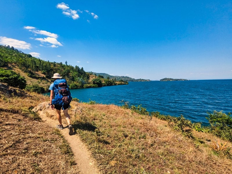
The Congo Nile Trail is one of the most popular adventure routes in Rwanda, stretching about 227 km from Gisenyi (Rubavu) to Rusizi (Cyangugu). Adventure seekers can hike or cycle the full route or choose shorter options depending on time—up to 10 days on foot or about 5 days by mountain bike—while enjoying amazing views of Lake Kivu, terraced hills, and the authentic warmth of local communities.
Travelers can enjoy the Congo Nile Trail through Roads of Adventure Safaris. For those with ample days, the best plan is to begin in Gisenyi (north Lake Kivu)—especially after gorilla trekking in Volcanoes National Park—and continue down to Rusizi (south Lake Kivu), with an onward connection to Nyungwe National Park. If your days are fewer, we recommend tackling the route in short, flexible stages.
⛺10-Day Hiking Itinerary Cong Nile trail (On Foot)
If you plan to explore the Congo Nile Trail by hiking, you can follow these step-by-step stages. With enough days, you can cover the entire route over 10 days on foot, or for shorter trips you can do short magagbe (stage-by-stage) hikes.
Day 1: Gisenyi to→ Cyimbili
- Distance: 16.5 kilometers
- Where to Stay: Cyimbili Guest House
- What to See: BRALIRWA brewery bay, local coffee washing stations, and initial lakeside vistas.
We begin our foot trek right outside the buzzing border town of Gisenyi near the BRALIRWA brewery. The terrain starts with unpaved dirt lanes that quickly remind your legs about Rwanda’s legendary thousand hills. You will follow winding paths that hug the shoreline of Lake Kivu, passing active local abajambo (fishermen) repairing their traditional three-hulled wooden vessels. The landscape is incredibly lush, dominated by smallholder plots of green banana trees and sweet cassava leaves. The hardship today comes from adjusting to the humid lakeside air and the initial, relentless uphill gradients on loose rock. However, the simplicity of passing through quiet imidugudu (villages) where children shout “Amakuru!” (How are you!) makes the physical strain vanish. My past groups always marvel at how quickly the urban noise fades into pure nature here. By afternoon, we will arrive at the peaceful Cyimbili estate, where the scent of drying coffee beans hangs heavy in the air. You will sleep in basic but remarkably clean guest rooms right near the water.
Day 2: Cyimbili to→ Kinunu
- Distance: 13 kilometres
- Where to Stay: Kinunu Guest House or local homestays
- What to See: Nkora fishing village, extensive coffee plantations, and traditional bean sorting.
Today is a shorter but intensely scenic march deeper into the heart of Rwanda’s primary coffee-growing region. We leave Cyimbili early to beat the equatorial sun, navigating narrow single-track footpaths that cut directly across terraced hillsides. You will descend into the lively Nkora fishing settlement, which is a fantastic spot to observe the morning trading of the overnight isambaza (sardine-like fish) catch. The landscape transforms into endless rows of glossy-leaved coffee trees blanketing the slopes right down to the water's edge. Walking here demands steady footwork as the dirt tracks are frequently uneven and rutted by heavy seasonal rains. The simplicity of life here is striking; you will see mothers carrying firewood gracefully on their heads and elders resting outside mud-brick homes. We will walk past farmers meticulously washing coffee cherries at community cooperatives. Our home for the night is Kinunu, perched on a ridge that catches the evening lake breeze perfectly.
Day 3: Kinunu to→ Musasa
- Distance: 16 kilometres
- Where to Stay: Musasa Homestay
- What to See: Rural valleys, local markets, and views of distant Congolese mountains across the lake.
Get ready for an authentic slice of rural Rwandan hospitality as we trek toward Musasa. The trail takes us away from the immediate lake shore, pushing inland into deep agricultural valleys and steep ridges. The terrain involves walking on loose red-clay roads that turn remarkably slick if a sudden afternoon shower catches us. You will feel the true physical demands of the trail today as we tackle several long, gradual inclines under the open sky. Along the paths, we will encounter locals transporting massive bunches of amatoki (green bananas) on sturdy single-speed bicycles to the nearest market. There are no luxury amenities out here; it is all about the simple joy of sharing a path with friendly farmers. At Musasa, we will stay in an authentic community homestay. Sleeping on simple beds and eating locally grown sweet potatoes and beans prepared over an open fire gives you a true connection to the land.
Day 4: Musasa to → Kibuye (Karongi)
- Distance: 28 kilometres
- Where to Stay: Home Saint Jean or Bethany Hotel
- What to See: Dramatic bays of Karongi, local wood-carving workshops, and the famous islands.
This is the longest and most physically punishing stage of the northern section, but it is an absolute classic. We will cover a massive distance over a series of high ridges that test your knees and endurance. The landscape is a masterpiece of steep valleys, eucalyptus forests, and dramatic peninsulas jutting into the cobalt-blue waters of Lake Kivu. As your guide, I will remind you to sip water constantly because the heat on these open dirt roads can be intense. The simplicity of this walk lies in the rhythm of your boots against the earth, broken only by the melodic singing of women working in the communal fields. As we near Kibuye, the old name locals still prefer over Karongi, the lake reveals its iconic islands like Napoleon Island, famed for its fruit bats. We will finish the day at Home Saint Jean, a historic guest house built next to a church on a high hill, providing a sweeping view of the bays below.
Day 5: Kibuye to→ Mugonero
- Distance: 30 kilometres
- Where to Stay: Mugonero Orphanage Homestay or local lodges
- What to See: Dramatic drop-offs, lakeside schoolyards, and traditional dance performances.
We are now entering the southern half of the trail, where the landscape opens up even more dramatically. This stage presents a significant challenge due to the sheer length and the rolling nature of the path. We will walk through vibrant villages where local children will likely join us for a few kilometres, practicing their school English. The terrain alternates between hard-packed paths and rural tracks that curve around expansive bays. You will experience the genuine hardship of walking long distances under the hot sun, but the simple sights—like a craftsman weaving traditional baskets under a tree—keep your spirits high. In the afternoon, we will arrive at Mugonero, a quiet community known for its welcoming spirit. If we are lucky, the local youths will perform a traditional Intore dance for us, stamping their feet to the rhythm of heavy wooden drums. It is an incredible, uncommercialised experience that stays with you long after you return home.
Day 6: Mugonero to → Karengera
- Distance: 15 kilometres
- Where to Stay: Karengera Community Centre or local guesthouses
- What to See: Rice paddies in the low valleys, small rural markets, and local churches.
After the long march of yesterday, today gives our legs a bit of a breather with a shorter distance, though the hills are still ever-present. We will descend into fertile valleys where the landscape changes from hillside crops to bright green rice paddies fed by mountain streams. The paths here are narrow and simple, woven between farming plots where locals cultivate maize and beans. Walking through these communities highlights the modest, self-sufficient lifestyle of the rural population. The terrain includes some steep, rocky sections that require careful stepping, but the pace is relaxed. You will witness the daily routine of village life: women washing clothes by the streams and men constructing houses from mud and eucalyptus poles. We will find accommodation at a modest guesthouse in Karengera, where a cold beverage and a simple meal of rice and goat brochette taste like an absolute feast after a long walk.
Day 7: Karengera to→ Kumbya
Distance: 18 kilometres
- Where to Stay: Kumbya Retreat Centre
- What to See: Kumbya peninsula, ancient trees, and exceptional lakeside birdlife.
Today's trek leads us to one of the most hidden gems on the entire Congo Nile Trail: the peaceful peninsula of Kumbya. The trail follows dirt tracks that wind through quiet hamlets and cassava plantations before heading down toward a secluded tongue of land sticking out into Lake Kivu. The landscape here feels old and untouched, with massive indigenous trees that provide a welcome canopy of shade after days on open roads. The simplicity of Kumbya is deeply soothing; it was originally set up as a quiet religious retreat, and it retains that atmosphere of absolute stillness. You will notice the rich birdlife, from colourful kingfishers diving for fish to majestic fish eagles calling from high branches. The physical hardship today is minimal compared to previous days, allowing you to reflect on the journey. We will camp or stay in simple wooden cottages right on the water's edge, falling asleep to the gentle lapping of the lake.
Day 8: Kumbya to → Nyamasheke
- Distance: 24 kilometres
- Where to Stay: L'Esperance Orphanage or local parish guesthouses
- What to See: Large tea plantations, historical trading posts, and bustling town markets.
We leave the tranquility of Kumbya behind to head toward Nyamasheke, a historic district with a busier local energy. The landscape transitions beautifully as we climb higher into hills where the air cools down and massive tea estates begin to appear, looking like vast green carpets spread over the ridges. The terrain involves a mixture of dirt tracks and some stone-paved roads that can be hard on the soles of your feet. The hardship today comes from a few long, sustained climbs as we move away from the lake shore and into the high hills. However, the simplicity of stopping at a tiny roadside shop to enjoy a fresh, sweet banana and a chat with the shopkeeper makes the effort worthwhile. Nyamasheke is rich with history, having been an important administrative spot since the colonial era. We will spend the night in a basic guest house run by a local community project.
Day 9: Nyamasheke to → Shangi
- Distance: 22 kilometres
- Where to Stay: Shangi Catholic Mission or local homestays
- What to See: Historical sites, old German colonial buildings, and panoramic lake lookouts.
This stage brings us to Shangi, a place of immense historical importance in Rwanda. The trail takes us through rolling hills and small valleys where traditional brick-making cooperatives operate. You will see locals digging clay, shaping bricks by hand, and baking them in massive wood-fired kilns. The landscape remains dominated by agriculture, with patchworks of different crops covering every available inch of fertile land. The terrain features several steep descents and climbs that require steady knees, especially if the red dirt is dry and dusty. In Shangi, we will see the spot where the first German colonial residents established their post, alongside an old Catholic mission. The simplicity of staying at the mission or a nearby local home gives you a window into the deep-seated faith and community spirit of the region. The views of the lake from the high cliffs of Shangi are absolutely magnificent.
Day 10: Shangi to→ Rusizi (Cyangugu)
- Distance: 18.3 kilometres
- Where to Stay: Peace Guesthouse or Emeraude Kivu Resort
- What to See: Kamembe town, the Ruzizi River border, and the edge of Nyungwe Forest.
The final leg of our incredible foot journey takes us from Shangi down to the bustling border town of Rusizi, traditionally called Cyangugu. The terrain for this last day involves navigating about three final hills with long, gradual inclines that will test your remaining stamina. The heat down in this southern valley can become quite oppressive as midday approaches, making the hike feel somewhat heavy. Instead of running right along the lake shore, the path winds through a peaceful valley beside a small river, bordered by endless fields of local crops. The simplicity of completing the trail is a quiet, proud feeling. There is no grand archway at the official end, so we will walk right into the heart of the town to celebrate. You have walked across the entire western spine of Rwanda! We will check into our final accommodation overlooking the water, where you can look back across the lake toward the Democratic Republic of Congo and reflect on the hardships and simple joys of the past ten days.
⛺The 5-Day Biking Congo Nile Trail Itinerary (Cycling Version)
For those choosing two wheels, a mountain bike transforms the Congo Nile Trail into a fast, bumpy, and exhilarating test of aerobic fitness. Let us look at the 5-day biking stages.
Day 1: Gisenyi to → Kinunu (Biking)
- Distance: 36.5 kilometres
- Where to Stay: Kinunu Guest House
- What to See: Pfunda tea factory views, Nkora fishing village, and lakeside single-tracks.
Your cycling journey starts with an immediate reminder that Rwanda is not flat. Leaving Gisenyi, we bypass the slower footpaths and take on the main dirt roads that climb steadily above the lake. The terrain today consists mostly of rocky, unpaved tracks that require excellent bike handling and strong legs. If you are booking through Roads Of Adventure Safaris, they will ensure your front suspension is well-tuned because the constant vibrations on the loose gravel can be exhausting. The landscape flashes past in a blur of bright green banana groves and steep hillsides. The main hardship today is managing your pacing on the sharp, short climbs that hit you one after another. You will ride down through the Nkora fishing village, where you must navigate carefully around pedestrians, livestock, and local bicycle taxis. The simplicity of rolling into Kinunu on a bike, covered in fine red dust but cooled by the lake air, is unmatched.
Day 2: Kinunu to → Kibuye (Karongi) (Biking)
- Distance: 44.5 kilometres
- Where to Stay: Home Saint Jean or Moriah Hill Resort
- What to See: Musasa valleys, rural trading centres, and the spectacular entry into Kibuye bay.
This is arguably the most demanding cycling day of the entire trip. We cover the ground of two full hiking days, meaning we will face multiple major ridge crossings. The landscape is incredibly dramatic, with the trail plunging into deep agricultural valleys before climbing straight back up onto high ridges with sheer drops down to Lake Kivu. The terrain is a mix of hard-packed earth and loose shale. The true hardship comes during the midday heat when tackling climbs with gradients that occasionally force even experienced riders to get off and push. The simplicity of the villages we pass provides a wonderful distraction; communities here rarely see vehicles, so a cyclist is always greeted with cheers of “Mwiriwe!” (Good afternoon!). As we make the final descent into Kibuye, the view of the islands scattered across the quiet water makes every ounce of sweat worth it.
Day 3: Kibuye to→ Mugonero (Biking)
- Distance: 41.5 kilometres
- Where to Stay: Mugonero Community Lodgings
- What to See: The high Gisovu tea region boundaries and deep lakeside inlets.
We head south from Kibuye, tackling a route that climbs high into the hills before dropping back toward the lakeside village of Mugonero. The terrain on this stage is a real mix; you will encounter some sections of smooth, newly paved road alongside older, rugged dirt tracks that snake around the massive fingers of the lake. The landscape here becomes noticeably wilder and higher in altitude as we edge closer to the famous Congo-Nile watershed divide. The physical hardship comes from the long, sustained climbs where your lungs will feel the altitude. The simplicity of life remains the dominant theme, however, as we pass small mountain schools where children line up along the fences to wave. We finish the ride with a fast, sweeping descent into Mugonero, where a basic bed and a hearty meal of local tilapia fish await our tired bodies.
Day 4: Mugonero to → Shangi (Biking)
- Distance: 64 kilometres
- Where to Stay: Shangi Parish Guesthouse
- What to See: Kumbya peninsula from above, Nyamasheke tea estates, and historical landmarks.
This is a massive day on the saddle, covering a huge distance that combines sections of the paved southern highway with rough detour tracks through the villages. The landscape is a beautiful transition from the open lake views to the high, cool ridges dominated by the sprawling tea plantations of Nyamasheke. The terrain allows for some fast riding on the tarmac sections, but the real work happens when we veer off onto the dirt tracks to visit the communities. The hardship today is pure physical fatigue; your legs will feel every single kilometer of the rolling topography. But the simple pleasures—like stopping at a tiny village market to buy fresh avocados and sharing a laugh with the local vendors—keep the energy high. We will arrive in the historic village of Shangi late in the afternoon, with just enough time to watch the sun sink below the horizon from the high cliffs.
Day 5: Shangi to → Rusizi (Cyangugu) (Biking)
- Distance: 40.5 kilometres
- Where to Stay: Peace Guesthouse or local hotels in Kamembe
- What to See: Rural river valleys, Kamembe town, and the majestic Ruzizi River.
Our final day on the bikes takes us from the historic heights of Shangi down to the lake terminus at Rusizi. The terrain drops down into a lower valley system, following dirt roads that run parallel to a small river rather than the open lake shore. The landscape is full of active agricultural plots where you will see locals harvesting cassava, sweet potatoes, and maize. The hardship on this final leg is primarily the rising heat and dust as we descend into the lower altitude of the Rusizi basin. The simplicity of the ride is beautiful; it is an easy, gradual roll compared to the brutal climbs of the first few days. We will ride right up to the official cycle trail marker in the middle of town to complete the journey. It is a fantastic feeling to look at your dust-covered mountain bike and realize you have just ridden across the entire length of western Rwanda.
What is the physical fitness level required to tackle the 10-day Congo Nile Trail hike?
You do not need to be an elite athlete, but you do need good cardiovascular endurance and sturdy joints because Rwanda’s terrain is relentlessly steep. Over a ten-day period, you will consistently encounter sustained ascents and loose descents that test your knees and stamina, particularly under the equatorial sun. If you can comfortably walk 15 to 30 kilometers on uneven dirt tracks for multiple consecutive days, your body will adapt to the rhythm of the path. Preparing months in advance with stair climbs and weighted day-hike training makes a massive difference. When your legs grow tired, the support team from Roads of Adventure Safaris can help adjust logistics or luggage carriage so you can focus entirely on putting one foot in front of the other. It is not a race; the secret is maintaining a steady, slow pace and drinking plenty of water rather than pushing yourself to exhaustion early in the morning.
How do I handle luggage and gear logistics if I book through Roads of Adventure Safaris?
Carrying a heavy backpack for ten straight days drains your energy and ruins the joy of walking. When you organize your journey through Roads of Adventure Safaris, they typically arrange a support vehicle or local porters to transport your main luggage from one guesthouse or camp to the next. You only need to carry a lightweight daypack containing your water bladder, raincoat, sunscreen, camera, and personal snacks for the day's stretch. This setup protects your back and lets you enjoy the remote pathways unburdened. Coordination happens smoothly behind the scenes, ensuring your dry clothes and toiletries wait for you in your room when you limp into the guesthouse compound by late afternoon. Be sure to pack your gear in water-resistant bags or use rain covers because sudden downpours can catch anyone off guard on these mountain ridges.
What kind of accommodations can I genuinely expect along the trail?
Accommodation ranges from rustic community homestays and basic church mission guesthouses to comfortable lakeside lodges depending on the specific stop. In places like Cyimbili, Kinunu, and Musasa, you will stay in modest guest rooms or authentic village homes where beds are simple, electricity might rely on solar panels, and warm water is sometimes bucket-style. As you move closer to larger hubs like Karongi (Kibuye) or the southern terminus in Rusizi, you gain access to standard hotels featuring private en-suite bathrooms and reliable Wi-Fi. Staying in these diverse places gives you a balanced perspective of rural life without sacrificing basic hygiene. Roads of Adventure Safaris pre-books these spots to ensure you always have a clean bed waiting, even in the most isolated hamlets where commercial tourism infrastructure is still developing.
What are the best months of the year to plan this trek in terms of weather?
The ideal windows for tackling the Congo Nile Trail are during Rwanda’s dry seasons, which generally run from June to September and from December to February. During these months, the dirt tracks remain firm, the skies stay clear for sweeping lake views, and you avoid the slippery mud that makes steep clay paths hazardous. However, because the trail sits within a mountainous region flanking a massive inland body of water, localized showers can happen at any time of year. Walking in the dry season means you manage dust and heat rather than sliding down hillsides in torrential downpours. Roads of Adventure Safaris monitors seasonal weather shifts closely and helps travelers select the exact weeks that minimize rain disruptions while maximizing clear photography conditions.
Can I combine the Congo Nile Trail with gorilla trekking in Volcanoes National Park?
Combining these two adventures creates the ultimate Rwandan itinerary because they sit geographically close to one another in the country's northwest. Most travelers fly into Kigali, transfer straight to Volcanoes National Park for a morning gorilla tracking session, and then spend that afternoon driving down to Gisenyi to kick off the Congo Nile Trail. Starting in Gisenyi allows your legs to warm up on the northernmost lakeside stages before heading deep into the southern hills. Roads of Adventure Safaris routinely packages these permits and logistics together so your gorilla permits and hiking arrangements flow seamlessly without administrative gaps. It transitions you smoothly from the misty bamboo forests of the high volcanoes down to the warm, sparkling waters of Lake Kivu.
What essential gear and clothing items should I pack specifically for this route?
Packing for the Congo Nile Trail requires a careful balance between lightweight breathability and protection against changing weather. You need at least two pairs of well-broken-in trail running shoes or lightweight hiking boots with aggressive tread patterns to handle loose gravel and mud. Bring moisture-wicking shirts, durable hiking trousers or shorts, a wide-brimmed sun hat, polarized sunglasses, and a reliable waterproof jacket. A high-capacity power bank is non-negotiable because many rural guesthouses lack charging points or experience frequent power cuts. Bringing blister patches, moleskin, and electrolyte powder packets will save your feet and hydration levels when the afternoon heat peaks. Roads of Adventure Safaris provides a detailed packing checklist prior to departure so you never find yourself missing crucial items out in the remote valleys.
How safe is it to walk or cycle the Congo Nile Trail independently versus with a guide?
Rwanda ranks consistently as one of the safest nations on the African continent, and the local communities along the trail are exceptionally welcoming to travelers. Walking independently is entirely possible because the route is marked with trail signs, but having a local guide completely changes the experience. A guide fluent in Kinyarwanda translates interactions with farmers, steers you away from confusing unmarked junctions, and shares deep historical context about places like Shangi and Nyamasheke. When you travel with Roads of Adventure Safaris, their professional guides know every hidden shortcut, community leader, and scenic viewpoint along the 227-kilometer stretch. Their presence provides an extra layer of reassurance, ensuring your safety, cultural respect, and logistical smoothness from start to finish.
What local food and drinking water options are available along the way?
Culinary options on the trail lean toward simple, wholesome, locally sourced ingredients rather than gourmet dining. Lunch stops often feature fresh local avocados, sweet potatoes, plantains, maize, and beans served at small roadside spots or prepared by your guesthouse hosts. For dinner, you can frequently order fresh tilapia or isambaza caught straight from Lake Kivu, accompanied by rice or fries. Regarding hydration, tap water is not safe for drinking, so you must rely on bottled water, filtered water supplied by your lodges, or a personal water purification system. Roads of Adventure Safaris ensures clean drinking water is readily available in support vehicles or at your accommodation stops, keeping your stomach safe and your energy levels high throughout the trek.
What medical preparations or vaccinations do I need before starting the trip?
Before traveling to Rwanda, you must check current health requirements, which typically include proof of yellow vaccination for entry. It is also wise to consult a travel clinic regarding malaria prophylaxis, typhoid, and routine boosters like tetanus and hepatitis A. Because you will be exerting yourself in high-altitude, humid conditions, carrying a robust personal first-aid kit containing rehydration salts, anti-diarrheal medication, painkillers, and heavy-duty insect repellent is essential. Local clinics exist in larger districts like Karongi and Nyamasheke, but remote stretches between villages have no medical facilities. Roads of Adventure Safaris trains its guides in basic wilderness first aid and carries emergency communication gear in case unexpected health issues arise on the trail.
How difficult is the cycling version compared to the hiking itinerary?
Mountain biking the Congo Nile Trail compresses the physical journey into five days, requiring intense technical bike handling and explosive cardiovascular output. While hikers take ten days to absorb the terrain at a walking pace, cyclists face massive daily distances—often between 35 and 64 kilometers—over sharp, loose-gravel climbs and technical descents. You need strong upper body strength to combat continuous handlebar vibrations and excellent leg power to conquer steep gradients without burning out. If you choose the cycling option through Roads of Adventure Safaris, they supply well-maintained mountain bikes with front suspension, helmets, and repair kits, plus a support vehicle trailing nearby in case of mechanical failures. It is a thrilling way to experience the route if you possess solid off-road riding experience.
What is the best way to interact respectfully with local communities and children?
The communities along the Congo Nile Trail are characterized by incredible warmth, with children frequently shouting greetings of "Amakuru!" from the roadside. To maintain respectful interactions, always ask for permission before taking photographs of individuals, especially elders and working farmers, rather than treating them like tourist attractions. Avoid handing out money or candy to children along the path, as this encourages begging habits; instead, you can support local cooperatives by purchasing fresh fruit or handmade crafts. When you travel with Roads of Adventure Safaris, your guide will brief you on cultural etiquette and help bridge language gaps so your exchanges feel genuine and mutually respectful. Showing basic courtesy creates deep, memorable human connections that outlast the physical journey itself.
Are there mobile phone networks and internet connectivity along the trail?
Cellular coverage across Rwanda is surprisingly robust, powered by providers like MTN and Airtel, even in many rural parts of the western province. You will find that signal strength fluctuates depending on whether you are standing high on a exposed ridge or trapped deep inside a agricultural valley. Buying a local SIM card at Kigali International Airport upon arrival gives you affordable data access for maps and messaging. However, many remote guesthouses offer weak or intermittent Wi-Fi, making this trek a wonderful opportunity to disconnect from digital noise. Roads of Adventure Safaris keeps lines of communication open through local SIMs so your support team can coordinate logistics and check in with your loved ones back home.
What historical and cultural landmarks should I look out for during the trek?
The western province of Rwanda holds layers of deep history, from early German colonial outposts to ancient trade routes along Lake Kivu. In Shangi, you will encounter historical buildings and mission sites that mark early European settlement patterns, while towns like Nyamasheke preserve stories of old administrative trading posts. Throughout the valleys, you can observe traditional brick-making cooperatives, coffee washing stations like those in Cyimbili and Kinunu, and fishermen harvesting catch using traditional wooden boats. Roads of Adventure Safaris designs their itineraries to pause at these significant historical nodes so you understand the socioeconomic fabric of the region rather than just walking past it blindly. These cultural stops enrich your understanding of how modern rural Rwanda has evolved.
What are the banking and cash-handling realities in remote villages along the route?
Cash is absolute king once you leave major urban centers like Gisenyi, Karongi, and Rusizi. While hotels and larger guesthouses in towns accept credit cards or mobile money payments, remote roadside shops, community homestays, and local markets operate strictly in Rwandan Francs cash. ATMs are available in district capitals, but they occasionally run out of cash or experience power outages, meaning you should withdraw sufficient local currency before stepping onto the trail. Small denomination notes are vital because village shopkeepers struggle to provide change for large bills when you buy bottled water or snacks. Roads of Adventure Safaris advises clients on cash budgeting protocols and ensures your major package costs are settled beforehand so money troubles never interrupt your adventure.
How does the weather and terrain shift as you move from the north to the south?
The northern section of the trail near Gisenyi features dramatic lake views, volcanic soil textures, and rolling hills dominated by coffee plantations and fishing villages. As you progress south past Karongi toward Mugonero and Nyamasheke, the topography intensifies, featuring steeper drop-offs, higher altitude ridges, and massive commercial tea estates that carpet the hills in vibrant green. The southern valleys also feel wilder and more isolated, with lower population densities and more rugged tracks. Roads of Adventure Safaris prepares travelers for this geographic transition, ensuring your physical pacing adjusts appropriately as the terrain grows more demanding in the southern half of your journey. Each section of the trail offers a distinct visual personality that prevents the landscape from feeling monotonous.
What wildlife and bird species can I expect to spot while walking the trail?
While the Congo Nile Trail is not a traditional big-game safari route, the region teems with rich biodiversity, particularly avian life and forest-dwelling creatures. Lake Kivu's shores host magnificent fish eagles, colorful kingfishers, and cormorants darting across the water, while peaceful sanctuaries like the Kumbya peninsula offer serene birdwatching environments. As you move closer to the southern terminus near Nyungwe National Park, the air fills with the calls of various forest birds and occasional primate sightings near the park boundaries. Roads of Adventure Safaris includes knowledgeable local guides who can spot and identify these species, turning your daily walking hours into an educational nature walk rather than just a physical endurance test.
How can I handle laundry and clothing maintenance during a multi-day trip?
When you sweat through red clay dust and humidity for several hours a day, keeping your clothes clean becomes a practical challenge. Most guesthouses and hotels along the trail offer basic laundry services, where local staff hand-wash your garments and dry them under the tropical sun within 24 hours for a small fee. Alternatively, you can pack a small bar of travel laundry soap and wash essential socks and underwear yourself in your room's basin. Quick-drying synthetic fabrics dry much faster overnight than heavy cotton items. Roads of Adventure Safaris coordinates laundry logistics with your accommodation providers so you do not have to waste your rest hours scrubbing gear after a grueling 25-kilometer walking day.
What language is primarily spoken, and how well do locals understand English?
Kinyarwanda is the universal language spoken by every resident along the trail, from village elders to playing school children. In major towns and established tourist lodges, English and French are spoken reasonably well by staff and service providers. However, out in the rural farming communities, locals may only know basic English greetings like "How are you?" or "Good morning." Having a local guide from Roads of Adventure Safaris eliminates any communication barrier, allowing you to converse deeply with coffee farmers, artisans, and shop owners. Learning a few simple Kinyarwanda words like "Muraho" (Hello) and "Murakoze" (Thank you) goes a long way in sparking warm smiles and building instant rapport with villagers.
What happens if an injury or extreme fatigue prevents someone from finishing a stage?
Unexpected physical burnout, twisted ankles, or severe blisters can happen to anyone during a demanding multi-day trek across rugged terrain. Because the trail intersects with several regional roads and rural feeder tracks at various points, rescue and extraction are entirely manageable. If you book through Roads of Adventure Safaris, their logistical support network allows vehicles to access strategic checkpoints along the route. If a traveler cannot complete a specific afternoon stretch, the support team can arrange a vehicle pick-up to transfer them safely to the evening's guesthouse. This safety net provides immense mental relief, ensuring nobody is forced to push through a dangerous medical situation out in the remote wilderness.
How do I book a customized Congo Nile Trail itinerary through Roads of Adventure Safaris?
Booking a tailored journey through Roads of Adventure Safaris is a straightforward process that begins by reaching out via their official website or direct communication channels. You share your available travel dates, whether you prefer hiking or mountain biking, your preferred style of accommodation, and any specific interests like coffee farm tours or cultural visits. Their local experts then craft a personalized itinerary that matches your fitness level and schedule, handling all permits, guesthouse reservations, guiding fees, and luggage logistics in advance. This personalized approach guarantees that your expedition through western Rwanda runs smoothly from the moment you land until your final departure. It takes the stress out of planning so you can focus entirely on enjoying the road ahead.