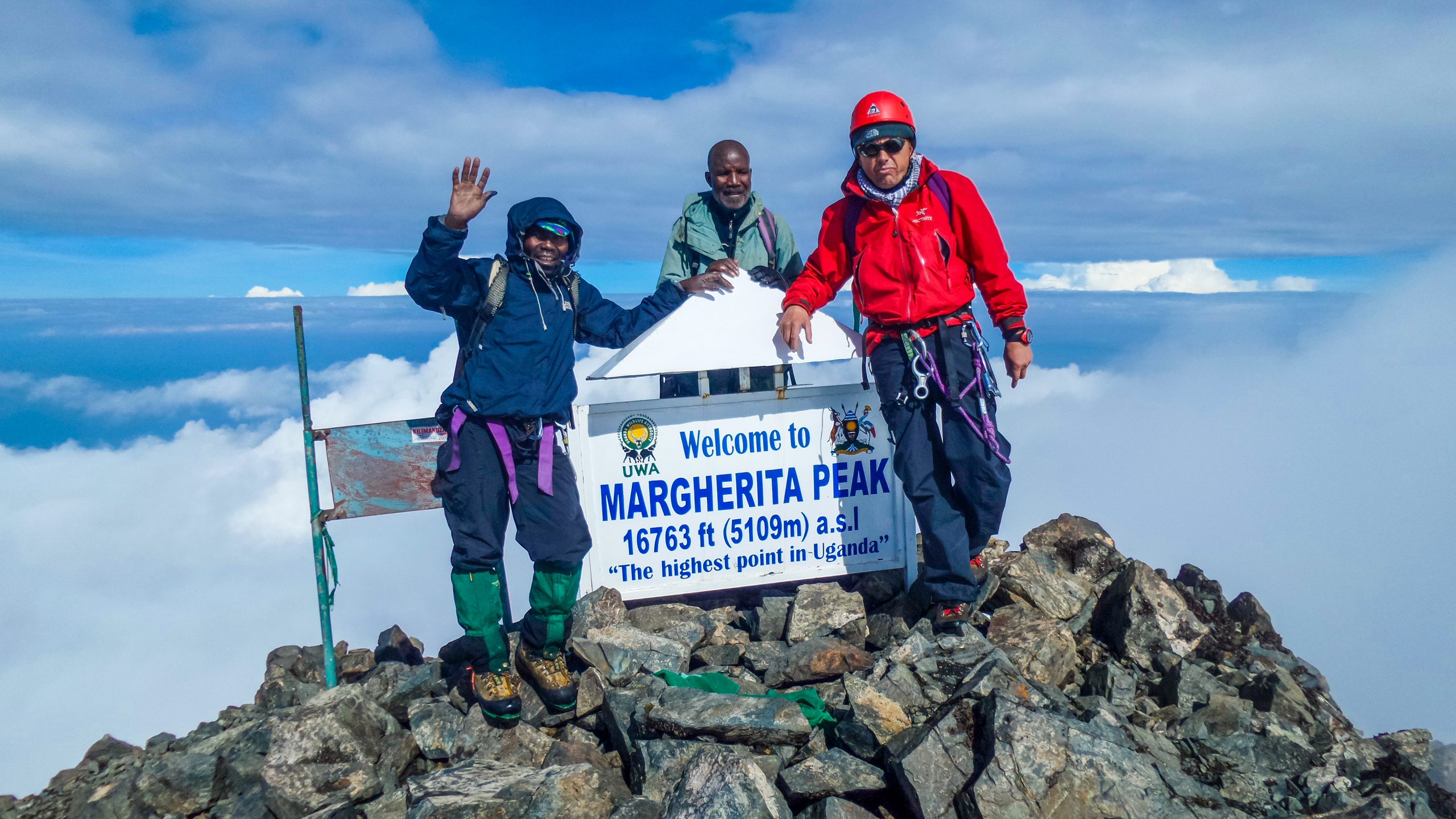
This 9-day Rwenzori hike and climb expedition provides a direct route to Africa’s third-highest point. Operating within the Rwenzori Mountains National Park, the journey consists of a 7-day trek along the traditional Central Circuit and 2 days of vehicle transit. The route begins at the Nyakalengija base camp at 1,615 meters and rises to the summit of Margherita Peak on Mount Stanley at 5,109 meters. Trekkers cross five distinct ecological zones, moving from montane forests to alpine glaciers. The route requires navigating complex terrain, including the mud-filled Bigo Bogs, steep ridges, and high-altitude mountain passes. Assisted by local Bakonjo guides and porters, participants manage severe elevation shifts and freezing temperatures. This 9-day Rwenzori hike itinerary demands physical endurance and basic technical alpine skills, delivering a raw, practical mountaineering experience through an isolated glacial environment.
Day 1: Transit & Briefing
Your Ugandan mountaineering expedition begins with a scenic 7-hour drive from Kampala westward to the rugged Kasese district. You will proceed directly to the Rwenzori Mountaineering Services (RMS) basecamp at Nyakalengija, situated at an altitude of 1,615 meters. This crucial first day focuses entirely on logistics, park registration, and vital safety briefings. Rangers will meticulously inspect your technical alpine gear, including crampons, harnesses, and ice axes. You will rent any missing specialized equipment, weigh your duffel bags, and get matched with local Bakonjo porters and guides whose ancestral knowledge is indispensable. A restful night at a base camp lodge prepares your body for the strenuous multi-day foot journey ahead into the legendary "Mountains of the Moon."
Day 2: Nyakalengija to Nyabitaba Camp (2,651 m)
The trek officially kicks off from the Nyakalengija park gate at 1,615 meters. You will hike for 5 to 7 hours, covering approximately 8 kilometers of challenging terrain. The trail initially winds through vibrant Bakonjo farmlands, offering a glimpse of local crops like cassava and banana shambas. You will soon cross the rushing Mahoma River, entering the boundary of the Rwenzori Mountains National Park. The path transitions into a dense, montane forest zone filled with chimpanzee calls and blue monkeys. The final stretch requires a steep, demanding scramble up a massive forested ridge. Your destination is Nyabitaba Camp, sitting at 2,651 meters on a ridge crest, which provides stunning views of the Portal Peaks and the Mubuku valley.
Day 3: Nyabitaba to John Matte Camp (3,505 m)
An energetic 6-hour trek pushes you deeper into the wilderness, spanning a rigorous 7-kilometer trail. From Nyabitaba Camp, you will initially descend through a pristine bamboo forest to cross the suspension bridge over the roaring Mubuku River at Kurt Shafer Bridge. From here, the route climbs steeply into the hauntingly beautiful giant heather zone, where trees are draped in thick layers of old-man's-beard moss. You will navigate slippery, moss-covered rocks and treacherous tree roots along the path. The trail opens up into the lower fringes of the moorland zone as you approach John Matte Camp, positioned at 3,505 meters. This camp sits just near the banks of the Bujuku River, offering chilly alpine temperatures.
Day 4: John Matte to Bujuku Hut (3,962 m)
Prepare for an intense 4 to 5-hour trek covering roughly 6 kilometers through the infamous Rwenzori wetlands. You will cross the freezing Bujuku River and enter the Lower Bigo Bog, navigating the notorious mud by hopping across giant tussocks and specialized boardwalks. The landscape feels prehistoric, dominated by towering giant lobelias (Lobelia deckenii) and massive groundsels (Senecio). You will ascend past the Upper Bigo Bog into the stunning Bujuku Valley. The trail levels out slightly as you approach the shores of Lake Bujuku, a glacial lake reflecting the towering peaks. You will arrive at Bujuku Hut, situated at a high 3,962 meters, strategically nestled in a valley between Mount Speke, Mount Baker, and Mount Stanley.
Day 5: Bujuku to Kitandara Hut (4,023 m)
Today features a demanding 4 to 5-hour trek over 4 kilometers, tackling extreme alpine topography. Leaving Bujuku Hut, you will climb through muddy groundsel forests on the steep slopes of the Scott-Elliot Pass. The trail rises sharply, requiring hands-on scrambling over wet boulders to reach the pass summit at a dizzying 4,372 meters. From this high vintage point, you will enjoy breathtaking panoramic views of Mount Stanley’s glaciers and the deep valleys below. The route then plunges into a steep, rocky descent down the southern side of the pass. You will pass the spectacular Twin Lakes of Kitandara before arriving at Kitandara Hut, nestled beautifully at 4,023 meters right next to the lower lake shore.
Day 6: Kitandara to Elena Hut (4,541 m)
This short but grueling 3 to 4-hour ascent serves as your final approach to the high camp, covering about 3 kilometers. From the Kitandara lakes at 4,023 meters, you will immediately face a steep climb up a rocky, exposed ridge known as the Elena headwall. The vegetation rapidly disappears, replaced by cold rock, scree, and patches of ice as you enter the afro-alpine Afro-alpine zone. You will navigate slippery granite slabs and the edges of the Stanley Plateau. The air grows noticeably thin as you ascend to Elena Hut, perched on a bleak, rocky outcrop at 4,541 meters. This basic metal hut serves as the cold, wind-swept launchpad for summit day, situated directly below the massive Elena Glacier.
Day 7: Summit Day (Margherita Peak 5,109 m)
Your ultimate alpine challenge begins with an intense, pre-dawn wakeup call around 2:00 AM. You will start the grueling 8 to 12-hour round-trip summit push in freezing darkness. Strapping on crampons, harnesses, and ropes, you will navigate the steep, crevassed Elena Glacier. You will traverse the icy Stanley Plateau, cross the border dip, and tackle the steep, technical ice wall of the Margherita Glacier. Reaching Margherita Peak on Mount Stanley at 5,109 meters rewards you with standing on Africa's third-highest point. After celebrating above the clouds, you will carefully retrace your steps, abseiling down the technical rock and ice sections back to Elena Hut, before continuing your long descent to Kitandara Hut at 4,023 meters for overnight rest.
Day 8: Descent to Nyabitaba Camp
Your long downward journey requires 7 to 8 hours of strenuous trekking, covering nearly 11 kilometers. Leaving Kitandara Hut, you will face a short, sharp uphill climb back over the Scott-Elliot Pass or follow the alternative lower loop trails. From the alpine heights, the route begins an extended, knee-jarring descent through changing ecological zones. You will slide down muddy slopes, re-enter the surreal forests of giant groundsels, and cross the familiar boardwalks of the Bigo Bogs. The air grows warmer and richer in oxygen as you descend past John Matte Camp and drop down through the giant heather zone. The exhausting day concludes back at Nyabitaba Camp (2,651 m) for your final night on the mountain.
Day 9: Return & Transit
The final leg of your Rwenzori expedition is a quick, celebratory 2-hour descent covering the remaining 5 kilometers. You will hike down the steep ridge from Nyabitaba Camp, passing through the bamboo forest and the lower montane canopy where you might spot black-and-white colobus monkeys. You will arrive back at the Nyakalengija park gate (1,615 m) to officially sign out of the Uganda Wildlife Authority registry. Here, you will receive your summit certificates and bid a warm farewell to your hardworking Bakonjo guides and porters. Your private safari vehicle will be waiting to transport you on the 7-hour return drive back across the equator to Kampala or Entebbe International Airport.
What technical mountaineering gear do I need to pack?
Planning for the Rwenzori terrain means preparing for both thick mud and vertical glacial ice. Because this is a serious alpine climb, you cannot just show up in standard trekking boots and a rain jacket. You will need highly specialized gear to safely navigate the upper peaks. Crucial items include a pair of semi-rigid or rigid mountaineering boots compatible with crampons, a climbing harness, an ice axe, and a couple of locking carabiners. You will also need mechanical ascenders and prusik loops for the fixed ropes on the Margherita Glacier. Do not skimp on your apparel either; heavy-duty waterproof shells, thermal base layers, and thick mountaineering gloves are non-negotiable to prevent hypothermia in freezing high-altitude downpours. Down at basecamp, the team at Nyakalengija can help you rent heavier items like crampons, ice axes, and harnesses if you do not want to fly with them. However, bringing your own well-broken-in mountaineering boots is highly recommended to avoid severe blisters on the trail. Make sure to pack plenty of dry bags too, because the Rwenzori moisture has a sneaky way of penetrating even the best backpacks.
How physically fit do I need to be?
You need to be in exceptional, peak physical cardiovascular condition to complete this loop. This is widely considered one of the most physically demanding treks on the African continent, far surpassing Kilimanjaro in terms of sheer terrain difficulty. You are not just walking on a well-maintained path; you are actively scrambling over wet boulders, pulling yourself up via thick tree roots, and wading through knee-deep mud for hours at a time. The summit day alone demands eight to twelve hours of continuous, grueling physical exertion at elevations well above 4,000 meters. To prepare for this, your training regimen should start at least three to six months before your departure date. Focus heavily on intense cardiovascular endurance, such as long-distance running, cycling, and swimming. Most importantly, spend hours hiking uphill with a weighted backpack to condition your legs and core for the relentless elevation gains. Strength training targeting your quadriceps, hamstrings, and calves will help protect your joints during the steep, knee-jarring descents down Scott-Elliot Pass. If you are not comfortable pushing your body to its absolute physical limits day after day, this specific trek will prove incredibly overwhelming.
What is the best time of year to climb?
Timing your expedition perfectly is critical because the Rwenzori range is notoriously wet, receiving rain throughout most of the year. The absolute best windows for climbing are during the region's two dry seasons. The primary and most reliable window runs from late June through August, followed by a slightly shorter dry spell from late December to February. During these dry months, you will experience clearer morning skies, less relentless rainfall, and slightly more manageable trail conditions in the lower bogs. However, you must keep in mind that "dry season" in a tropical rainforest ecosystem is a highly relative term. It can still rain or snow heavily at any given moment, especially once you cross into the higher alpine zones. Climbing during the peak wet seasons—specifically from March to May and September to November—is highly discouraged for average trekkers. Heavy downpours transform the steep mountain trails into dangerous, slippery mudslides, and the high-altitude bogs can swell significantly, making them incredibly exhausting to cross. Furthermore, thick fog frequently rolls in during the rainy months, severely reducing your visibility and blocking the rewarding panoramic views of the surrounding glaciers.
How do I prevent severe acute mountain sickness?
Preventing acute mountain sickness requires strict adherence to a slow, disciplined pace. The golden rule in the Rwenzoris is "pole pole," which translates to "slowly, slowly" in Swahili. Even if you feel incredibly energetic, rushing your ascent will quickly backfire as your body struggles to adapt to the rapidly thinning air. The Central Circuit itinerary is deliberately structured to give your body a fighting chance, gradually stepping up your sleeping elevations from 1,615 meters to over 4,500 meters. You must drink massive amounts of water—aim for four to five liters daily—to combat dehydration, which accelerates altitude symptoms. Many climbers consult their doctors beforehand to get a prescription for Diamox, a medication that helps speed up the natural acclimatization process. Pay close attention to your body's signals; mild headaches and minor fatigue are common, but severe throbbing headaches, persistent vomiting, or loss of physical coordination are serious red flags. If you or your guides notice symptoms of High-Altitude Pulmonary Edema or Cerebral Edema, you must immediately drop down to a lower camp. There is absolutely no shame in descending to save your life.
What role do local Bakonjo porters play?
The local Bakonjo porters and guides are the undeniable backbone of every single Rwenzori expedition. Without their incredible strength, deep cultural knowledge, and mountain expertise, completing this trek would be virtually impossible for most international climbers. These individuals have lived in the foothills of the mountains for generations, meaning their bodies are naturally adapted to the high altitudes and grueling terrain. Porters carry the heavy communal gear, including food supplies, cooking gas, and your main duffel bags, leaving you to carry only a light daypack. They navigate the deep, treacherous mud pools with absolute grace, frequently pointing out the safest footholds and hidden roots to step on. Beyond the physical labor, your Bakonjo guides act as your alpine navigators, safety officers, and cultural ambassadors. They monitor the unpredictable mountain weather patterns, manage the safety ropes on the slippery glaciers, and keep your spirits high with local songs and stories around the evening mess tables. Treating your porter crew with the utmost respect, paying fair wages, and offering generous tips at the end of the trip is an essential part of responsible mountaineering etiquette.
What are the mountain huts actually like?
The accommodation along the classic Central Circuit consists of basic, unheated wooden or metal mountain huts. These structures are designed strictly for practical shelter and survival, rather than luxury or comfort. Inside the huts, you will typically find communal bunk spaces equipped with simple foam mattresses, but you must bring a high-quality, four-season sleeping bag to stay warm during the freezing nights. There is no electricity, running water, or cellular service available once you leave the base camp, so bringing a couple of heavy-duty power banks is essential to keep your camera batteries charged. Toilet facilities at the camps are rustic, consisting of basic long-drop pit latrines located in separate outhouses nearby. The common dining areas are where everyone gathers to dry out damp clothing, drink hot tea, and swap stories after a long day on the muddy trail. Because the high-altitude air is incredibly damp and cold, items rarely dry out completely overnight, so keeping a dedicated set of dry clothes sealed inside a waterproof bag specifically for sleeping is a smart strategy to ensure you stay warm and comfortable.
What kind of food is served on trial?
Despite the remote and incredibly harsh wilderness conditions, the camp chefs prepare surprisingly hearty and nutritious meals to keep your energy high. You burn an immense number of calories scrambling through the mud and climbing steep ridges, so the menu focuses heavily on carbohydrates and warm, easily digestible foods. A typical breakfast includes hot porridge, eggs, sausages, toasted bread, and plenty of instant coffee, tea, or hot cocoa. For lunch, the kitchen crew usually packs a portable lunch box filled with sandwiches, fruit, boiled eggs, and biscuits to eat during a brief trail break. Dinner is the main culinary highlight, featuring large communal platters of pasta, rice, or potatoes served alongside fresh vegetables, beef stew, chicken, or fish sauces. The chefs also make an effort to incorporate local Ugandan staples, such as matooke (steamed green bananas) and groundnut sauce, offering a great taste of the local culture. If you have specific dietary restrictions, such as being vegetarian or gluten-free, simply inform your tour operator well in advance so the shopping team can purchase the correct supplies before heading to basecamp.
Is the Margherita Glacier climb highly technical?
Yes, climbing the final stretch to Margherita Peak is a genuine, technical alpine mountaineering challenge. Unlike Kilimanjaro, which is a high-altitude walk up scree slopes, the Rwenzoris require you to actively traverse moving glacial ice and steep rock faces. When you reach the edge of the Elena and Margherita glaciers, you will need to put on your harness, strap on your crampons, and rope up to your guide and team members. You will use an ice axe for balance and self-arrest, and you must know how to navigate steep ice inclines ranging from thirty to sixty degrees. There are sections where you will use mechanical ascenders to haul yourself up pre-installed fixed ropes over slick, near-vertical rock sections. The physical environment changes constantly due to rapid melting, creating new crevasses and exposed rock gaps that require careful foot placement. While you do not need to be a professional ice climber, having basic familiarity with crampon movement and rope management is highly beneficial. Your local guides will provide a quick refresher course on how to move safely on the ice during your briefing days.
What makes the Rwenzori vegetation so unique?
The plant life in the Rwenzori Mountains is completely unlike anything else you will see on Earth. Because the range experiences high rainfall, intense tropical sun, and freezing nighttime temperatures, the plants have evolved into giant, prehistoric forms. As you hike through the different elevation zones, you will feel like you are walking through a fantasy landscape. In the lower moorlands, you will encounter the famous giant groundsels (Senecio), which look like massive, mutated trees topped with thick rosettes of leaves. You will also walk among towering giant lobelias, which shoot up like massive green pillars amidst the misty bogs. The heather zone features trees covered in thick, dripping carpets of bright green moss and hanging old-man's-beard lichens, creating an eerie, enchanted forest atmosphere. These plants have developed unique survival mechanisms, such as closing their leaves tightly at night to protect their delicate cores from frost bites. Walking through these botanical zones feels like stepping back millions of years in time, providing a fascinating distraction from the immense physical exhaustion of the daily uphill climbs.
How much cash should I bring for tips?
You should plan to bring a substantial amount of cash to cover tips and personal expenses. Tipping your mountain crew is a deeply ingrained tradition in East African mountaineering, representing a vital bonus for their hard work. While tipping amounts can vary based on your satisfaction, a general guideline is to budget roughly one hundred and fifty to two hundred and fifty US dollars total for your entire support team. It is highly recommended to distribute these tips directly to each individual—including your head guide, assistant guides, camp chef, and personal porters—during the final day's farewell ceremony at the Nyakalengija gate. Make sure to bring clean, crisp, uncreased US dollar bills printed after 2013, as older notes are routinely rejected by local banks and exchange bureaus in Uganda. Alternatively, you can exchange your foreign currency into Ugandan Shillings in Kampala or Kasese before the trek starts, which is often preferred by the local porters for their daily shopping. You will also want a bit of extra cash on hand to buy cold beers, sodas, and handmade souvenirs from the local community groups at basecamp.
Booking 9 Days Rwenzori hike and climb with us Roads of Adventure safaris
Booking your expedition through local experts like Roads of Adventure Safaris streamlines your entire journey to Margherita Peak. A typical 9-day itinerary with them balances two transit days with seven days of intensive trekking along the Central Circuit or Kilembe trails. They handle the complex logistics, including national park permits, equipment rentals, and coordinating with expert Bakonjo guides and porters. Your daily schedule shifts from hiking through lower montane forests to navigating high-altitude bogs, culminating in the technical, roped glacial ascent to the 5,109-meter summit. It is a seamless, fully supported way to experience this raw alpine challenge.