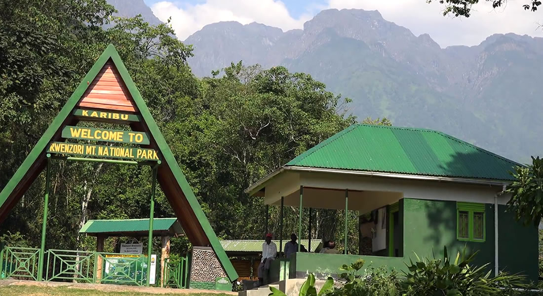
Conquer the legendary "Mountains of the Moon" with this definitive 8-day Rwenzori mountaineering expedition. Navigating the iconic Central Circuit, this rigorous trek ascends through five distinct ecological zones, culminating at Uganda’s highest point: Margherita Peak on Mount Stanley ( ). You will witness pristine afro-alpine wilderness, navigate the challenging Bigo Bog, and traverse the ancient Stanley Glacier. While physically demanding, this itinerary balances steep ascents with crucial high-altitude acclimatization, ensuring safer passage through rugged terrain. Supported by local Bakonzo guides, you will experience the dramatic landscapes that make this UNESCO World Heritage site a bucket-list achievement for alpinists worldwide.
The 8-Day Expedition Itinerary
Day 1: Kampala to Kasese (The Equatorial Journey)
Your adventure begins in the bustling capital of Kampala for a scenic 6 to 7-hour drive covering roughly  westward to Kasese town. The journey transitions from the urban sprawl into lush rolling hills, offering a memorable stop at the Equator line in Kayabwe for photography and a brief physics demonstration. You will pass through vibrant trading centers like Mubende and Fort Portal, catching glimpses of vast tea plantations. As you approach the foothills of the Rwenzori Mountains, the dramatic silhouette of the range looms in the distance. The day concludes with a briefing by your local Bakonzo guides at your lodge near the Nyakalengija trailhead (
 ), where final gear checks are conducted to ensure readiness for the strenuous, high-altitude days ahead.
Day 2: Nyakalengija to Nyabitaba Hut ( )
)
The trekking commences at the Nyakalengija park headquarters. You will complete park registration and meet your team of porters before setting off on a 4-hour hike covering  . The trail initially snakes through local Bakonzo homesteads, fields of coffee, and banana plantations before crossing the boundary into the national park. You will follow the rushing waters of the Mubuku River, crossing it via a suspension bridge at the Mahoma River confluence. The path turns sharply upward, forcing a steep climb through dense, humid montane forest filled with blue monkeys and three-horned chameleons. The day ends at Nyabitaba Hut (
 ), positioned on a ridge that offers breathtaking evening views of the massive Portal Peaks cutting through the mist.
Day 3: Nyabitaba to John Matte Hut ( )
)
Prepare for a demanding 5 to 6-hour trek covering  as you ascend into the eerie giant heather zone. The trail drops down from Nyabitaba Hut to cross the Kurt Shafer Bridge, which spans the roaring confluence of the Mubuku and Bujuku rivers. Beyond the bridge, a grueling, muddy climb awaits up the steep Bamboo Zone. You will navigate slippery moss-covered rocks and twisted roots, entering the lower reaches of the infamous Bigo Bog. This marshy expanse requires careful stepping across tussocks of grass to avoid sinking into the mud. The air grows noticeably thinner and colder as you finally reach John Matte Hut (
 ), located just near the banks of the Bujuku River, offering stunning vistas of the glacier-capped peaks ahead.
Day 4: John Matte to Bujuku Hut ( )
)
Today’s 4 to 5-hour trek spans  and plunges you deeper into the heart of the alpine zone. You will immediately face the upper Bigo Bog, crossing a series of wooden boardwalks installed to protect the fragile ecosystem and aid hikers. As you exit the bog, the trail climbs steeply past the tranquil Lake Bujuku. This glacial lake sits in a deep, U-shaped valley carved by ancient ice sheets. The surrounding landscape features surreal forests of giant groundseils (Senecio) and lobelias that resemble an alien world. The trail brings you to Bujuku Hut (
 ), nestled in a strategic valley directly between the imposing walls of Mount Speke and Mount Stanley, providing an optimal vantage point for acclimatization.
Day 5: Bujuku to Elena Hut ( )
)
A short but incredibly intense 4-hour climb covering just  elevates you to the rocky base camp. Leaving Bujuku Hut, the trail leads through muddy ground before tackling a steep, vertical ascent up the sides of the valley through the Scoop Pass. You will scramble up slick, mossy rocks and loose scree slopes using your hands for balance. The vegetation completely disappears, replaced by cold, bare rock formations and patches of snow. The thin air at this altitude requires a slow, deliberate pace to prevent altitude sickness. You will arrive at Elena Hut (
 ), a basic metal shelter bolted to the exposed rock faces of Mount Stanley. Here, you will prepare crampons, ice axes, and harnesses for the midnight summit bid.
Day 6: Elena Hut to Margherita Peak ( ) to Kitandara (
 )
)
Summit day demands an alpine start around 2:00 AM. A grueling 3-hour climb over cold rock and ice brings you to the edge of the Stanley Glacier. After strapping on crampons and roping up, you will cross the glacier, drop into a steep crevasse, and ascend the steep Margherita Glacier. A final, technical rock scramble leads you to Margherita Peak () around sunrise, standing proudly atop the third-highest point in Africa. After celebrating, you will descend back to Elena Hut for a brief rest, then continue down past Bujuku Hut and over the steep Scott-Elliot Pass ( ). The long, 8 to 10-hour day concludes with a descent to the stunning Kitandara Lakes and Kitandara Hut (
 ).
).
Day 7: Kitandara to Guy Yeoman Hut ()
Your journey home begins with a tough 5 to 6-hour trek covering . The day opens with a steep, technical climb out of the Kitandara valley up to Freshfield Pass ( ). On a clear morning, the pass offers sweeping panoramic views back toward the Congo border and the southern glaciers. Once over the pass, the long descent begins through muddy trails and fields of giant groundseils. You will pass the historic Bujongolo rock shelter, which was used by early explorers like the Duke of Abruzzi during his landmark 1906 expedition. The trail drops sharply through vertical bogs and into the upper bamboo zone before arriving at Guy Yeoman Hut (), situated alongside the scenic Mubuku River.
Day 8: Guy Yeoman to Nyakalengija to Kampala (The Final Descent)
The final leg of the trek is a 5-hour descent covering  back to civilization. The trail drops steeply through the remaining bamboo forests, requiring careful footing over wet, slippery rocks. You will complete the loop as you rejoin the path near Nyabitaba Hut and make the final descent down to the Nyakalengija park headquarters (). After bidding farewell to your Bakonzo porters and guides, you will receive your official summit certificate. Your driver will be waiting to transfer you back to Kampala on a 6 to 7-hour road trip. You will arrive in the capital city by late evening, concluding an epic, life-changing mountaineering journey through the heart of Africa.
What is the total trekking distance covered over eight days?
Navigating the Central Circuit of the Rwenzori Mountains is an endurance test that covers roughly 50 to 55 kilometers of highly technical terrain. While a horizontal distance of around 32 miles might sound modest compared to flatter hikes, the rugged topography completely changes the math. You aren't just walking forward; you are constantly moving vertically, scrambling over exposed tree roots, wading through knee-deep mud bogs, and climbing steep rock faces.
On an average day, you will cover anywhere from 4 to 10 kilometers. However, due to the extreme elevation changes and challenging underfoot conditions, a 6-kilometer stretch can easily take five to six hours to safely negotiate. The longest and most demanding day is undoubtedly the summit bid on Day 6, where you will push through an intense alpine ascent and a massive descent, keeping you on your feet for up to 10 grueling hours. Every single kilometer in this environment feels thrice as long as a standard road kilometer because your body is fighting gravity, thin air, and highly unpredictable footing. Managing your physical energy across these 50-plus kilometers requires a slow, steady pace—what the local guides call "pole pole"—to ensure you don't burn out early.
How difficult is the climb up to Margherita Peak?
Climbing Margherita Peak is widely considered one of the most physically demanding mountaineering challenges on the African continent. Unlike Mount Kilimanjaro, which is primarily a high-altitude trek, the Rwenzoris require genuine alpine climbing skills and specialized equipment. The final push to the summit is a complex, multi-hour undertaking that involves navigating active glaciers, crossing deep crevasses, and scaling near-vertical rock faces.
You will be waking up in the freezing darkness around 2:00 AM, strapping on heavy crampons, roping up with your teammates, and using an ice axe to maintain three points of contact on the steep Margherita Glacier. The thin air at 5,109 meters severely limits your oxygen intake, making every single step an immense mental and physical battle. There is also a highly technical, exposed rock scramble right before you reach the summit ridge, which requires good upper body strength and absolute focus. Having a solid foundation of cardiovascular fitness, previous high-altitude experience, and a basic familiarity with rope teams will dramatically increase your chances of standing safely at the top. It is a true mountaineer's peak that demands respect, proper preparation, and deep resilience.
What specific gear is required for this alpine trek?
Packing for the Rwenzoris is unique because you must prepare for both a humid, muddy rainforest and a freezing, glaciated summit. For the lower zones, high-quality, knee-high rubber boots (often called Wellington boots) are absolutely essential; standard hiking boots will quickly get ruined or swallowed by the deep, thick mud of the Bigo Bog. You will also need breathable, moisture-wicking layers and heavy-duty waterproof rain jackets and pants, as it can rain heavily at any time of year.
As you transition into the alpine zone above Elena Hut, the gear requirements become strictly technical. You will need a climbing helmet, an adjustable mountaineering harness, mechanical ascenders, carabiners, an ice axe, and rigid crampons that fit securely over insulated, waterproof mountaineering boots. For clothing at high altitudes, a heavy down jacket, thermal base layers, windproof gloves, and a warm fleece balaclava are vital to protect against temperatures that regularly drop below freezing. Don't forget a high-quality, four-season sleeping bag to stay warm inside the unheated mountain huts, along with a reliable headlamp for the midnight summit push and UV-blocking sunglasses to prevent snow blindness on the bright glaciers.
Which local communities guide hikers through the mountain trails?
The undisputed backbone of every single Rwenzori expedition is the local Bakonzo community. For generations, the Bakonzo people have lived in the foothills of these mountains, developing an intimate, unparalleled knowledge of the ridges, weather patterns, and hidden trails. Today, they operate as the expert guides, professional cooks, and high-altitude porters who make these grueling expeditions possible for international travelers.
When you trek the Central Circuit, you are stepping into their ancestral home. The Bakonzo guides possess an amazing ability to navigate the slippery mud and steep rock faces with absolute grace, often carrying heavy supply loads while keeping a watchful eye on your safety. Beyond their physical strength, they bring the mountains to life by sharing rich oral histories, local folklore, and traditional names for the peaks and rivers. They are also experts at spotting the range's unique wildlife, from the elusive three-horned chameleons to rare alpine birds. By hiring local Bakonzo crews, your expedition directly supports the local economy, funds community education, and preserves cultural heritage. Their warmth, encouragement, and musical camaraderie around the evening dinner tables provide the vital emotional boost needed to conquer the peak.
What types of accommodation are used during the trek?
Accommodation along the traditional Central Circuit consists of a network of rustic, permanently established mountain huts strategically spaced a day's hike apart. These wooden and metal structures provide essential shelter from the harsh, wet, and windy alpine environment, offering a much more comfortable alternative to sleeping in tents on the soggy ground.
Inside huts like Nyabitaba, John Matte, and Bujuku, you will find communal bunk rooms equipped with simple foam mattresses. You will need to bring your own warm, low-temperature sleeping bag and a travel pillow. The amenities are very basic: there is no electricity, no running water, and no indoor plumbing. Long-drop eco-toilets are located in separate outhouses nearby, and washing water is collected from nearby glacial streams by the porters and heated for you in small basins. The highest camp, Elena Hut, is a stark, functional metal shelter bolted directly to the cold rock face at 4,563 meters. It is cramped and can get incredibly cold, but it serves its purpose perfectly as a secure launchpad for the midnight summit assault. The communal dining areas in the huts offer a cozy space to dry your gear and swap stories.
How do climbers properly acclimatize to prevent altitude sickness?
Proper acclimatization is the absolute golden rule for safely reaching the roof of the Rwenzoris. Because the itinerary ascends from Kasese to over 5,000 meters in just a few days, your body needs time to adapt to the rapidly decreasing atmospheric pressure and lower oxygen levels. The 8-day itinerary is explicitly engineered with this in mind, incorporating a gradual ascent rate and utilizing the classic mountaineering strategy of "climb high, sleep low."
For instance, spending a night at Bujuku Hut () before pushing up to the extreme heights of Elena Hut () gives your respiratory and circulatory systems a crucial window to produce more red blood cells. The most effective way to help your body adapt is to maintain a remarkably slow, deliberate physical pace throughout the day, even if you feel bursting with energy. Drinking four to five liters of water daily is essential, as dehydration accelerates altitude sickness. Hikers are closely monitored by guides for early symptoms like persistent headaches, dizziness, or nausea. Carrying preventative medication like Diamox is highly recommended, but listening to your body and communicating openly with your guide remains your best defense.
What unique vegetation zones will you hike through daily?
The Rwenzori Mountains boast one of the most diverse and visually stunning botanical progressions anywhere on Earth, taking you through five distinct ecological zones in a single week. You start in the lower montane forest zone ( to
to  ), a dense, humid jungle canopy filled with sprawling ferns, wild banana trees, and towering hardwoods. As you climb past Nyabitaba, you enter the surreal bamboo zone ( to
  ), where closely packed, golden stalks create a beautiful, maze-like atmosphere.
Higher still lies the eerie heather zone ( to  ), characterized by giant, twisted trees draped in long, ghostly strands of old man’s beard moss. Above , you enter the spectacular afro-alpine moorland zone. This prehistoric landscape is dominated by massive, alien-looking giant lobelias and towering groundseils that thrive in the freezing, boggy valleys. Finally, above
  , you break out into the bleak rocky alpine desert and ice zone. Here, all macroscopic plant life disappears completely, leaving only colorful lichens clinging to bare rock, patches of permanent snow, and the massive, ancient glaciers that cap the highest peaks.
When is the best time of year to climb?
While the Rwenzori Mountains can technically be climbed year-round, choosing the right season will dramatically impact your safety, comfort, and chances of a successful summit. The region experiences two distinct dry seasons each year, which offer the most favorable trekking conditions. The primary and longest dry window runs from late June through to September, followed by a shorter, slightly colder dry period from late December through to February.
During these months, you can expect less daily rainfall, clearer skies for morning photography, and slightly firmer trail conditions—though you should still prepare for plenty of mud. Conversely, the heavy rainy seasons occur from March to May and from October to December. Attempting the Central Circuit during these wet periods is exceptionally difficult; the bogs swell significantly, the trails become dangerously slick torrents of mud, and visibility drops to near zero due to dense fog. Furthermore, snow accumulation on the Stanley Glacier increases during the wet months, making the final technical climb up Margherita Peak far more treacherous. Planning your trip during the dry windows gives you the best weather to enjoy the epic views safely.
What wildlife species might you encounter on the trails?
Though the Rwenzoris are primarily celebrated for their dramatic landscapes and glaciated peaks, the lower ecological zones are teeming with unique, highly specialized wildlife. As you trek through the dense montane forests on the first two days, you are very likely to hear the loud, guttural calls of black-and-white colobus monkeys and blue monkeys swinging through the high canopy. The park is also home to the elusive Rwenzori duiker, a small forest antelope adapted to the steep slopes.
If you keep your eyes peeled on the branches, you might spot the extraordinary Johnston’s three-horned chameleon, a prehistoric-looking reptile native to these forests. The mountains are an absolute paradise for birdwatchers as well, hosting over 200 distinct species. You will likely see the brilliantly colored Rwenzori Turaco flashing its bright red wings, or see the striking white-necked raven soaring high above the alpine cliffs. As you ascend past the tree line into the high bogs and rocky deserts, larger mammal sightings become rare, but you will still encounter small sunbirds feeding on giant lobelia flowers, proving that life thrives even in these harsh altitudes.
How should you physically train for this mountain expedition?
Preparing your body for the physical toll of an 8-day Rwenzori trek requires a dedicated, months-long training regimen focused on cardiovascular endurance, leg strength, and core stability. You cannot rely on willpower alone; your muscles and joints must be conditioned to handle consecutive days of heavy exertion. The absolute best way to train is by doing long-distance hiking on steep, uneven terrain while wearing a weighted backpack.
If you don't have access to outdoor trails, spending hours on a gym stair-master or inclined treadmill is an excellent alternative. Incorporate strength training exercises like squats, lunges, and step-ups to build up the quad and calf muscles needed for the steep ascents and to protect your knees during the jarring, long descents. Cardiovascular workouts like running, swimming, or cycling three to four times a week will dramatically improve your lung capacity and heart efficiency, helping your body cope with the thin alpine air. Equally important is mental stamina; training on cold, rainy days helps build the psychological grit required to push through the muddy bogs and freezing summit winds with a positive attitude.
Booking 8 Days Mountain Rwenzori hike with us Roads of Adventure safaris
Experience the ultimate African alpine challenge by booking your expedition directly through the Roads of Adventure Safaris 8-Day Hike package. This comprehensive, hassle-free itinerary handles all your essential park permits and logistically complex arrangements seamlessly from the start. Guided by expert local mountaineers, you will traverse the legendary, time-tested Central Circuit route. The dramatic trail leads you step-by-step through five breathtaking, high-altitude ecological zones, preparing your body perfectly for the grand finale. Your journey culminates in an unforgettable, triumphant push to the snow-capped summit of Margherita Peak, standing proudly as the highest point in Uganda.