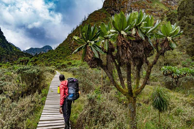
The 4-days Mountain Rwenzori hike is an efficient option for exploring the unique ecosystems of Uganda’s "Mountains of the Moon" without attempting a full peak ascent. Trekkers primarily choose between two paths: the Kilembe Trail up to the Mutinda Lookout or the Central Circuit Route via Nyakalengija. Both options guide participants through distinct, stratified altitude zones, including montane rainforests, dense bamboo thickets, and high-alpine bogs populated by giant lobelias. This abbreviated timeline is suited for physically fit walkers seeking high-altitude exposure, alpine photography, and specialized birdwatching. By reaching altitudes near  , hikers experience the dramatic topographic changes of the Rwenzori range while staying within established mountain huts. The following itinerary outlines the classic Central Circuit variant to Bujuku Camp.
Day-by-Day Itinerary
Day 1: Nyakalengija Trailhead ( ) to Nyabitaba Camp (
 )
)
The journey begins at the Uganda Wildlife Authority headquarters in Nyakalengija for registration, equipment checks, and a formal safety briefing. The initial  path crosses communal farmland before passing the official national park boundary. From there, the trail follows the northern bank of the Mubuku River through an undisturbed zone of sub-montane forest. Trekkers negotiate exposed tree roots and muddy inclines during this
  -to-
-to- hour opening stage. Wildlife sightings frequently include the three-horned chameleon, black-and-white colobus monkeys, blue monkeys, and the endemic Rwenzori turaco. The afternoon finishes with a steep, sustained ridge climb to Nyabitaba Camp, which provides wooden bunk accommodation and piped mountain spring water for the night.
Day 2: Nyabitaba Camp () to John Matte Camp ( )
)
This  section demands increased physical effort, requiring between
  and
and  hours of active movement. The path descends initially through a dense bamboo forest to the Kurt Schäfer Bridge, a suspension structure spanning the confluence of the Mubuku and Bujuku rivers. Beyond the river crossing, the trail ascends steeply over slick, moss-covered granite faces and enters the specialized giant heather zone. Hikers stop at the Nyamuleju rock shelter (
 ) for a midday rest, where views of Mount Stanley and Mount Speke are visible in clear weather. The final multi-hour stretch requires navigating the lower fringes of the high-altitude bogs before reaching John Matte Camp for dinner.
Day 3: John Matte Camp () to Bujuku Camp ( )
)
Covering a horizontal distance of  , this stage involves an altitude gain of
  over a -to- hour period. The route drops from the camp to cross the Bujuku River, directly entering the Lower Bigo Bog. Trekkers utilize a system of wooden boardwalks installed over the deep peat bogs, though some mud navigation remains necessary. The vegetation transitions into an alpine desert landscape dominated by massive groundsel trees and prehistoric giant lobelias. After climbing out of the Upper Bigo Bog, the path levels out near the shores of Lake Bujuku. Bujuku Camp sits in a glacier-carved valley framed by the steep rock walls of Mount Baker, Mount Speke, and Mount Stanley.
Day 4: Bujuku Camp () to Nyakalengija Trailhead ()
The final day consists of a long, continuous descent covering approximately  to complete the circuit loop. Leaving at dawn, hikers retrace their steps through the Upper and Lower Bigo Bogs back down to John Matte Camp for a short rest break. The descent continues down the steep heather ridges and back past the Kurt Schäfer Bridge, requiring careful footing on wet or muddy rocks. Total descent time ranges from to
  hours, depending on individual knee fatigue and trail conditions. The trek concludes back at the Mihunga Gate/Nyakalengija base, where hikers return hired gear, tip porters and guides, and board vehicles for their onward transfers
Is the day one climb to Nyabitaba Camp difficult?
The opening stretch to Nyabitaba Camp is a classic introduction to the realities of mountain trekking in Uganda. You begin at an altitude of  at the park headquarters, and over the course of about , you gain over a thousand meters of elevation. While the initial walk through the local farmlands starts relatively gentle, the terrain changes dramatically once you cross the official national park boundary. The rainforest path is highly uneven, crisscrossed by massive tree roots that can become incredibly slick when wet. The real physical test arrives at the end of the day with a long, sustained ridge climb. It requires steady footwork and decent cardiovascular fitness, taking anywhere from to hours. Your knees and lungs will definitely feel the effort by the time you spot the wooden huts of the camp. However, the presence of unique wildlife like blue monkeys and the striking Rwenzori turaco provides an excellent excuse to pause, catch your breath, and take photos, making the steady uphill grind much more manageable for average hikers.
What gear works best for crossing the Bigo Bog?
When you hit the Lower and Upper Bigo Bogs on day three, standard hiking boots simply will not cut it. The iconic peat bogs of the Rwenzori range are notoriously deep and muddy. Even though the park service has installed a system of wooden boardwalks over the worst sections, these planks can become submerged, slippery, and unstable. The absolute best gear choice here is a pair of high-quality, knee-high rubber boots, often called Wellington boots, paired with thick wool socks to prevent friction blisters. Many experienced trekkers switch out of their leather boots specifically for this stage. Additionally, telescoping trekking poles are indispensable. They help you test the depth of the mud before stepping off a board and provide vital balance on the wet wood. You also need heavy-duty, waterproof gaiters if you stick to leather boots, though mud can still overtop them. Combined with lightweight, breathable waterproof trousers to shield your legs from the abrasive giant heather and groundsels, you will stay dry and stable while navigating one of the most unique alpine wetland environments on the continent.
Can I see high peaks from John Matte Camp?
Yes, John Matte Camp offers some of the first dramatic views of the high peaks, but it depends entirely on the mountain's notoriously fickle weather. Sitting at an elevation of  , the camp is positioned right in the giant heather zone, elevated just enough to look up the valley toward the main glacial massifs. On a clear morning or during a late afternoon break in the cloud cover, you can look out toward the jagged profiles of Mount Stanley and Mount Speke. Mount Stanley holds Margheritah Peak, the highest point in the country. Because the Rwenzori range is famous for its dense mists and frequent rain showers, these snow-capped peaks often hide behind a thick blanket of fog. The landscape around the camp feels beautifully atmospheric and prehistoric even when shrouded in mist. If you are lucky enough to get a clear window of weather during your day two arrival or day three departure, the sight of equatorial glaciers towering above the giant groundsels is spectacular and provides a stark contrast to the dense green forests you climbed through on the first day.
How cold does it get at Bujuku Camp?
Bujuku Camp sits at a chilly altitude of  , making it the highest and coldest overnight stop on this particular four-day itinerary. Because it is nestled deep within a glacier-carved valley and surrounded by massive rock walls, the camp receives very little direct sunlight and traps cold air. During the daytime, temperatures hover around
  to
to  , but the moment the sun sets, the thermometer drops rapidly. Nighttime temperatures frequently plummet to freezing (
 ) or even a few degrees below, causing frost to form on the surrounding giant lobelias and alpine grasses. The unheated wooden cabins provide shelter from the wind and rain, but they do not retain heat. To stay comfortable, you need a high-quality sleeping bag rated to at least
  . Packing a thermal base layer, a thick fleece, a down jacket, a warm beanie, and gloves is essential for the evening. Drinking hot tea provided by your camp crew and changing into dry clothes immediately after arriving will help keep your core temperature up before turning in.
Are porters available for this short mountain trek?
Porters are readily available and are highly recommended for this itinerary. When you register at the Nyakalengija trailhead on day one, the local guiding cooperative assigns licensed porters to your group. These porters are incredibly fit locals who carry the bulk of your heavy gear, including your sleeping bag, extra clothing, and the group's food supplies, usually packing them in large waterproof bags. They carry loads up to  . Utilizing porters supports the local economy directly and leaves you free to carry just a small daypack with your water, rain gear, camera, and lunch. Walking with a lighter load is an immense advantage when navigating the steep mud fields, slick roots, and wooden boardwalks of the Bigo Bog. It allows you to focus on your balance and pace rather than straining under a heavy pack at high altitudes. The porters usually hike ahead to ensure the camp is prepared by the time you arrive, turning what could be an exhausting physical ordeal into a much more manageable and enjoyable wilderness experience.
Is altitude sickness common before reaching Bujuku Camp?
Mild symptoms of altitude sickness can definitely occur on this trek, particularly as you approach Bujuku Camp at . This four-day itinerary moves relatively fast, taking you from to nearly four thousand meters in just three days. Because you skip the extra acclimatization days built into longer summit itineraries, your body has to adapt quickly to the thinning air. By the time you reach John Matte Camp at on day two, or as you climb through the upper bogs on day three, you might experience mild symptoms like a light headache, slight dizziness, shortness of breath on inclines, or trouble sleeping. To minimize these risks, it is vital to walk at a slow, deliberate pace—a strategy the local guides call "pole pole." Drinking four to five liters of water daily helps your body acclimatize, and some hikers choose to take preventative medication like Diamox. Your guides are trained to monitor everyone for more severe signs of Acute Mountain Sickness, ensuring you stay safe throughout the journey.
What wildlife might I spot near Mubuku River?
The lower section of the trail along the Mubuku River on day one is the richest zone for wildlife viewing. As you walk through the lush montane forest, the canopy hums with activity. Look closely at the tree branches, and you might spot the magnificent Rwenzori three-horned chameleon, a rare, prehistoric-looking reptile endemic to these mountains. Up in the trees, black-and-white colobus monkeys and blue monkeys bound through the branches, crashing through the foliage. For birdwatchers, this zone is spectacular. The bright red and green feathers of the Rwenzori turaco are easy to spot against the green leaves, and its raucous call echoes along the river valley. You might also hear or see the sunbirds darting between flowering bushes. While larger mammals like forest elephants or leopards live within the national park, they stay deep in the dense undergrowth away from the main trails. The smaller creatures, primates, and colorful birds right along the Mubuku River provide plenty of distraction during your first day of trekking.
How long is the descent on day four?
The final day of the itinerary is a long, physically demanding journey that reverses almost the entire route in a single go. You will cover roughly of trail, dropping from the high-alpine environment of Bujuku Camp at all the way back to the park gates at . This massive descent takes between and hours of continuous walking. While going downhill removes the cardiovascular strain of climbing, it places a heavy tax on your knees, quadriceps, and ankles. You must carefully re-navigate the slippery boardwalks of the Bigo Bog, descend the steep, muddy slopes of the giant heather zone, and pick your way over the wet tree roots below Nyabitaba Camp. The terrain requires constant mental focus to avoid slipping, especially if it rains in the afternoon. Taking regular breaks at John Matte and Nyabitaba camps to rest your feet, adjust your boots, and eat snacks is essential for managing the fatigue before finally reaching the trailhead where your transport waits.
Are there clean toilets at the mountain camps?
The toilet facilities at the camps along the Central Circuit are basic, rustic pit latrines, which are typical for remote high-altitude wilderness routes. At Nyabitaba, John Matte, and Bujuku camps, the national park authority has constructed simple wooden outhouses situated a short walk away from the main bunkhouses. These outhouses feature a simple concrete or wooden slab with a drop hole. While park staff and guides do their best to keep these facilities clean and functional, they are heavily used and can smell bad, so keeping your expectations realistic is helpful. There is no running water for flushing, and you must bring your own toilet paper and hand sanitizer, as these are not provided. For nighttime visits, a reliable headlamp is essential to safely navigate the wet, rocky paths leading to the outhouses. Despite being basic, these structures are vital for protecting the fragile alpine watershed, keeping human waste contained and away from the pristine mountain streams you cross during the day.
Can I hire warm sleeping bags in Nyakalengija?
Yes, you can hire warm sleeping bags and other essential gear directly at the Nyakalengija trailhead before you start. The local community tourism hub and guiding offices maintain a rental store stocked with gear left by previous climbers or provided by local operators. Here, you can rent heavy-duty sleeping bags rated for freezing temperatures, rubber boots for the bogs, waterproof jackets, trousers, and trekking poles. While hiring gear locally is convenient and saves space in your luggage, inspecting the items carefully before setting off is smart. Check that the sleeping bag zippers work smoothly and look for any tears. If you are exceptionally tall or have a large shoe size, availability can sometimes be limited, so notifying your tour operator in advance ensures the right sizes are set aside for you. Relying on local rentals is an excellent way to support the local economy while securing the specialized gear needed for the cold nights at Bujuku Camp.
Booking 4-days Mountain Rwenzori hike with us Roads of Adventure safaris
To book your 4-day Rwenzori Mountain trek, reach out directly to Roads of Adventure Safaris via their Roads of Adventure Safaris Contact Page or use the Roads of Adventure Safaris Trip Inquiry to specify your preferred travel dates and group size.