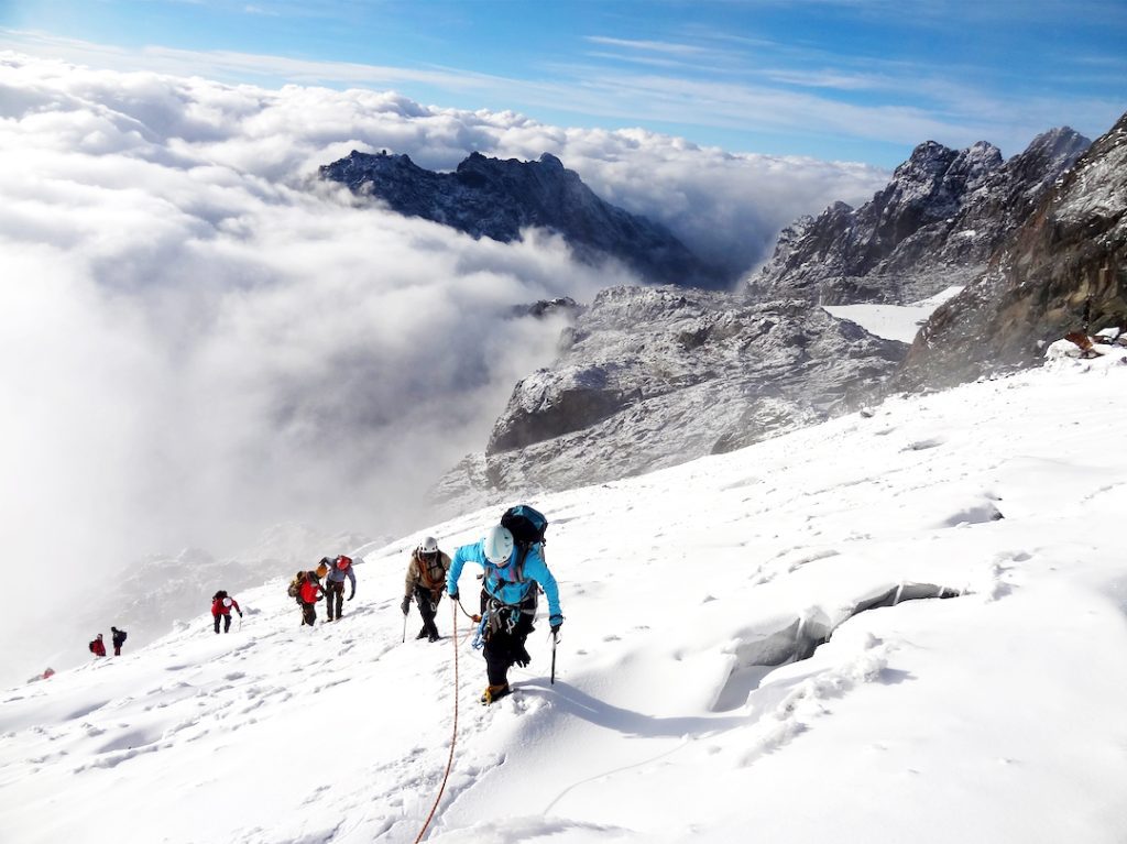
The 14-Day Rwenzori Ultimate Expedition is one of Africa’s most demanding alpine challenges. Traversing the mythical "Mountains of the Moon," this journey spans all six major massifs of the range: Mount Stanley, Mount Speke, Mount Baker, Mount Emin, Mount Gessi, and Mount Luigi di Savoia. Designed for experienced mountaineers, the trek requires technical equipment—including crampons, ice axes, harness systems, and ropes—along with exceptional cardiovascular endurance to navigate glaciated terrain, slippery moss-covered bogs, and steep rock scrambles. Starting from the Central Circuit trailhead at Nyakalengija, the route leads through distinct vegetation zones ranging from dense Afro-montane forests to glaciated peaks. This expedition offers a complete immersion into the heart of Uganda's high-altitude wilderness, testing endurance while delivering unparalleled vistas across Africa’s third-highest mountain range.
Detailed Daily Itinerary
Day 1: Overland Transfer from Entebbe to Kasese
Your alpine adventure begins with a scenic overland journey from Entebbe to Kasese, the gateway town situated at the foothills of the Rwenzori range. The drive spans approximately 350 kilometers and takes around 6 to 7 hours, winding past Uganda’s verdant countryside, sprawling tea estates, and rolling green hills. Along the route, you will cross the equator and pause for lunch while enjoying views of local rural settlements. Upon arrival in Kasese or the nearby village of Ibanda, you will check into your lodge for an evening briefing. Here, your lead guide will review equipment, inspect cold-weather layer systems and technical mountaineering gear, and discuss the weather conditions for the days ahead. A good night’s rest is essential as you prepare to transition from the lowland warmth to the rugged sub-alpine environments of the Rwenzori National Park the following morning.
Day 2: Nyakalengija (1,615m) to Nyabitaba Hut (2,651m)
The trekking phase begins at the Uganda Wildlife Authority trailhead in Nyakalengija at 1,615 meters. After meeting your team of local guides and porters and finalizing permit clearances, you set out along the Mubuku River valley. The path ascends gradually through Bakonjo farmland before entering the dense Afro-montane forest belt. As you climb, you cross the Mahoma River via wooden bridges and navigate forest tracks shaded by tall podocarpus trees, thick bamboo groves, and giant ferns. Keep an eye out for blue monkeys, Ruwenzori colobus, and colorful turacos along the way. The day finishes with a steady climb along a steep ridge until you reach Nyabitaba Hut, perched at 2,651 meters. Covering roughly 10 kilometers over 4 to 5 hours, this section offers clear views of the portal peaks and provides an ideal setting to rest and begin acclimatizing.
Day 3: Nyabitaba Hut (2,651m) to John Matte Camp (3,505m)
Leaving Nyabitaba early, the trail drops sharply through the forest down to the Kurt Shafer Bridge, spanning the roaring confluence of the Mubuku and Bujuku rivers. From the river crossing, you enter a dense bamboo forest zone where moss-covered rocks and muddy sections require careful footwork. Continuing upward, the vegetation transitions into the heather and moorland zone, dominated by giant lobelias and groundsel plants. You will negotiate the lower edge of the Bigo Bog, stepping across wooden boardwalks and grassy tussocks designed to navigate the fragile wetland ecology. The climb grows steadily steeper as you ascend along the northern side of the Bujuku River valley. By late afternoon, after about 6 hours and 11 kilometers of hiking, you arrive at John Matte Camp at 3,505 meters. This camp offers striking views of nearby ice-capped massifs on clear days and serves as your base for upcoming peak ascents.
Day 4: High-Altitude Excursion to Mount Emin (4,798m)
Today is dedicated to tackling Mount Emin, rising to 4,798 meters as the fourth-highest massif in the Rwenzori range. Departing John Matte Camp early, you head north across rugged, unmaintained alpine paths, leaving the main Central Circuit trail behind. The route ascends steep, narrow rock ridges and loose scree slopes through the isolated Mugusu Valley. Navigating this wild mountain demands strong scrambling skills and steady balance, as the ridges are exposed and often slick. While Mount Emin no longer holds permanent surface glaciers, cold conditions, high winds, and dense fog are common near the top. Reaching the twin-peaked summit area—specifically Umberto Peak at 4,798 meters—rewards you with sweeping views into the Democratic Republic of Congo and neighboring massifs. After taking photos and resting briefly, you retrace your steps down the technical ridge back to John Matte Camp over an intense 8-to-10-hour day.
Day 5: Alpine Ascent of Mount Gessi (4,715m)
Your second technical peak excursion focuses on Mount Gessi (4,715m), situated directly adjacent to Mount Emin in the northern section of the park. Leaving camp early, you branch off into the rugged northern gorge toward the Roccato Pass. The ascent moves through steep, slabby rock passages, lichen-covered boulders, and heavy brush. Navigating Mount Gessi requires careful route-finding due to the lack of heavily marked trails. Although its former glaciers have completely melted away, snow flurries and thin black ice can coat the upper rock faces, requiring extreme caution during technical scrambling steps. Upon reaching the summit ridge near Lolanda Peak at 4,715 meters, you are treated to dramatic views of Mount Stanley, Mount Speke, and the northern plains below. After absorbing the scenery, you descend back down through the gully system, completing a 7-to-9-hour trek to spend a third night at John Matte Camp.
Day 6: John Matte Camp (3,505m) to Bujuku Hut (3,962m)
Rejoining the main Central Circuit, the trail leads from John Matte Camp directly into the sprawling expanse of the Bigo Bog. You traverse this high-altitude wetland using boardwalks surrounded by surreal giant groundsels and lobelias. Beyond the bog, a steep climb brings you to Lake Bujuku, a serene alpine lake nestled in a dramatic glacial amphitheater flanked by Mount Stanley, Mount Speke, and Mount Baker. Walking along the lake's marshy shores, the thin air becomes increasingly noticeable as you cross the threshold toward 4,000 meters. You reach Bujuku Hut, situated at 3,962 meters, after approximately 5 hours and 6 kilometers of trekking. This location acts as the primary springboard for climbs on Mount Speke and Mount Stanley, giving your body extra time to adjust to the higher altitude in preparation for summit pushes.
Day 7: Summit Mount Speke (4,890m) & Proceed to Elena Camp (4,563m)
An alpine start at dawn begins the ascent of Mount Speke's highest point, Vittorio Emanuele Peak at 4,890 meters. The route climbs steeply up bare granite slabs, icy chimneys, and exposed scree gullies. While much of the permanent glacier has receded, fixed ropes or harness protection may be required depending on ice patches near the summit ridge. Standing atop Mount Speke offers panoramic views of the surrounding Stanley plateau and deep glacial valleys below. After enjoying the summit, you make a careful descent back toward the Bujuku Valley, then branch off onto the steep trail leading up to Elena Camp. Clambering up slick rock slabs, you reach Elena Hut at 4,563 meters by late afternoon. Perched on a high rocky ledge beside Mount Stanley's glaciers, this rugged camp serves as the launching pad for Margherita Peak.
Day 8: Summit Margherita Peak (5,109m) & Descend to Kitandara Hut (3,979m)
Waking around 2:00 AM, you gear up with harnesses, crampons, ice axes, and headlamps for the push to Margherita Peak, Africa's third-highest point at 5,109 meters. The climb crosses bare, frozen rock before stepping onto the Stanley Glacier. Rope teams navigate crevasse zones and icy slopes before reaching the steep ice wall below the summit. Using fixed lines and crampon technique, you negotiate the final ice ascent to stand on Margherita Peak on the border of Uganda and the DR Congo. After celebrating, you descend back to Elena Camp for a short rest, then continue downward via Scott-Elliot Pass (4,372m). Dropping into the valley where Lake Kitandara lies, you arrive at Kitandara Hut (3,979m) after a demanding 10-to-12-hour alpine effort.
Day 9: Ascent of Mount Baker (4,843m) & Return to Kitandara Hut
Today's target is Mount Baker (4,843m), the third-tallest peak in the Rwenzori range and fifth-highest in Africa. Leaving Kitandara Hut early, you ascend toward the sharp ridge line of Edward Peak along steep rock steps and loose moraine. Mount Baker requires sustained scrambling across exposed rock ridges that are frequently slick with frost or rain. As you gain elevation, the views back toward Lake Kitandara and the glaciated faces of Mount Stanley are spectacular. Reaching the summit of Edward Peak offers an extraordinary viewpoint overlooking the entire southern sector of the Rwenzori range. After absorbing the summit vistas and navigating the technical descent back down the rocky ridge, you return directly to Kitandara Hut at 3,979 meters after 6 to 8 hours of climbing to rest, rehydrate, and prepare for the final mountain summit of the trek.
Day 10: Ascent of Mount Luigi di Savoia (4,627m) & Overnight at Kitandara
The sixth and final major massif on this expedition is Mount Luigi di Savoia. Departing Kitandara Hut, you trek south toward Freshfield Pass before branching off toward the long, ridge-like structure of Luigi di Savoia. The climb passes through tussock grass, alpine heath, and rocky outcrops before reaching Sella Peak at 4,627 meters. Unlike the glaciated peaks, Mount Luigi di Savoia features sprawling mossy ridges and sweeping vistas across the southern limits of the national park. Standing atop Sella Peak marks the successful completion of all six principal mountain massifs of the Rwenzori range. After celebrating this milestone, you make the return trek across the high moorland terrain back to Kitandara Hut for your final night spent above 3,900 meters over a 7-to-9-hour round trip.
Day 11: Kitandara Hut (3,979m) to Guy Yeoman Camp (3,505m)
Beginning the return leg of the Central Circuit, you leave Kitandara Hut and immediately begin a steep climb up to Freshfield Pass at 4,282 meters. On clear mornings, the pass delivers panoramic farewell views back toward Mount Stanley and Mount Baker. Crossing the pass, you enter a vast alpine moorland field strewn with giant groundsels and lobelias. The trail then begins a prolonged descent through steep, muddy slopes around the Bujongolo and Kabamba rock shelters. You will navigate slippery mud, mossy boulders, and exposed roots, descending steadily alongside the upper reaches of the Mubuku River valley. By afternoon, after 5 to 6 hours and 6 kilometers of trekking, you arrive at Guy Yeoman Camp at 3,505 meters. The lower elevation and increased oxygen levels make for a comfortable evening in a picturesque mountain valley.
Day 12: Guy Yeoman Camp (3,505m) to Nyabitaba Hut (2,651m)
Leaving Guy Yeoman Camp, the trail continues its descent through the upper heather zone before dropping into deep bamboo forests. Today’s trek includes navigating steep, mud-slick sections, particularly around the cliff faces of Kichuchu. The path requires concentration as you step down wooden ladders and negotiate mossy roots that can be slick after rain. Along the route, you cross several mountain streams feeding into the Mubuku River and pass the scenic Kabamba Falls. As you descend below 3,000 meters, the thick bamboo gives way to the lush Afro-montane forest zone once again. The air becomes warmer, denser, and richer in oxygen. By late afternoon, after 6 to 7 hours and 10 kilometers of hiking, you complete the loop back at Nyabitaba Hut at 2,651 meters, closing the main circle of the circuit trail.
Day 13: Nyabitaba Hut (2,651m) to Nyakalengija (1,615m)
The final day of foot travel is a comfortable downhill trek from Nyabitaba Hut back to the park headquarters at Nyakalengija. Retracing the path from Day 2, you descend through the dense montane canopy, crossing the Mahoma River and passing local forest communities over 3 to 4 hours. The easier gradient allows you to set a relaxed pace while enjoying the sights and sounds of the forest, including birdlife and monkey troops moving through the trees. Upon reaching the trailhead at Nyakalengija (1,615m), you officially sign out with the Uganda Wildlife Authority rangers. You will be awarded summit certificates commemorating your multi-peak traverse before thanking your guides, porters, and support staff. Afterward, you transfer to your nearby lodge in Kasese or Ibanda to enjoy a long-awaited warm shower, relaxation, and a celebration dinner.
Day 14: Transfer from Kasese back to Entebbe / Departure
On the final day of your expedition, you enjoy breakfast at your lodge before meeting your driver for the private overland transfer back across Uganda. Leaving the Rwenzori Mountains behind, you travel east through Fort Portal or Mbarara, stopping along the way for lunch and souvenir shopping at local craft markets. The drive takes approximately 6 to 7 hours, offering plenty of time to relax and reflect on the extraordinary alpine achievements of the past two weeks. You arrive in Entebbe or Kampala by late afternoon or early evening, where you will be dropped off at Entebbe International Airport for your outbound flight or at your designated hotel for an overnight stay, marking the conclusion of an unforgettable Rwenzori expedition.
What fitness level is required for this 10-day climb?
Tackling the Rwenzori range requires an exceptional level of physical conditioning. You need solid cardiovascular endurance, strong legs, and the mental toughness to push through multi-hour ascents over unpredictable terrain. Beyond standard hiking fitness, your body must adapt to carrying a daypack while negotiating steep mud, slippery roots, and high-altitude mountain air. Preparing beforehand with intense hill training, heavy-pack hikes, and targeted strength workouts will make a massive difference in how much you enjoy the journey.
Which specific peaks are climbed during this 10-day itinerary?
This focused route targets the three most iconic massifs in the entire Rwenzori range. First, you tackle Mount Speke (4,890m), scrambling across bare granite to reach Vittorio Emanuele Peak. Next comes the ultimate objective: Mount Stanley, home to Africa's third-highest point, Margherita Peak at 5,109 meters. Finally, you take on Mount Baker (4,843m), scrambling its sharp rocky ridge to Edward Peak. It is a thrilling triple-crown alpine experience.
What technical gear is needed for scaling Margherita Peak?
When stepping onto the glaciated sections of Mount Stanley, full high-altitude alpine gear is mandatory. You will need broken-in mountaineering boots, sharp crampons, and a reliable ice axe for traction across frozen surfaces. Your guide will fit you with a climbing harness, helmet, and safety carabiners for roped team travel across crevasse fields and steep ice walls. High-quality waterproof layers, warm gloves, and UV-blocking glacier sunglasses are also non-negotiable to protect against severe high-altitude elements.
How challenging is foot movement through the Bigo Bog?
Navigating the legendary Bigo Bog is one of the most uniquely mental and physical tests on the Rwenzori trail. This ancient, mossy wetland features thick mud and deep tussocks that can easily swallow a misplaced step up to your knees. While park authorities have installed wooden boardwalks across major sections to ease travel and protect delicate flora, balancing on wet, slick timber requires total focus. Proper waterproof boots and sturdy trekking poles are absolute lifesavers here.
What type of accommodations are used along the trail?
Throughout the trek, you stay in basic mountain huts scattered along the circuit. These rustic, wooden shelters offer essential protection from the park's frequent rain, wind, and freezing nights. Sleeping arrangements are communal, featuring simple bunk beds or raised wooden platforms where you roll out your own cold-weather sleeping bag and pad. While amenities are rudimentary—think dry pit latrines and unheated common rooms—the camaraderie around the dining tables and the dry roof overhead make them welcome refuges.
How is high altitude sickness managed during the expedition?
Managing altitude sickness relies heavily on a measured, gradual pace and constant hydration. The itinerary builds in acclimatization days by slowly ascending through intermediate camps before launching into technical summit pushes. Guides closely monitor your oxygen levels and heart rate daily using pulse oximeters, watching for early symptoms like persistent headaches or nausea. Carrying personal altitude medication, drinking four liters of water daily, and strictly obeying the golden rule to "walk slow" (pole pole) keep risk low.
What clothing layers work best for changing mountain weather?
The weather in the Rwenzori Mountains changes rapidly, shifting from warm rainforest humidity to freezing summit winds in hours. A smart layering system starts with moisture-wicking synthetic or merino wool base layers to keep sweat off your skin. Next, add insulating fleece or lightweight down jackets to trap body heat during breaks. Finally, top it off with heavy-duty, waterproof gore-tex outer shells. Having reliable waterproof gloves and extra dry socks stashed in plastic bags is essential.
What role do local porters play during the hike?
Local porters are the true backbone of any successful Rwenzori expedition. Hailing from nearby Bakonjo communities, these resilient mountains experts carry heavy supply duffels, cook gear, tents, and safety equipment up steep, muddy paths. By taking the physical weight off your shoulders, they allow you to focus on trek pacing and safe foot placement. Working alongside them provides vital economic support to local families, and their vast knowledge of mountain weather adds incredible value to the journey.
What permits and logistics are required before setting off?
Before setting foot on the trail, you must secure official trekking permits from the Uganda Wildlife Authority. These fees cover park entry, certified mountain guides, armed ranger escorts, support porters, and mountain hut access. Expedition operators coordinate these logistics months in advance alongside private ground transfers to and from Kasese or Entebbe. Ensure your passport is valid for at least six months, secure your Ugandan tourist visa, and double-check that your international travel insurance explicitly covers high-altitude search and rescue.
When is the absolute best time to hike this route?
The best windows for trekking the Rwenzori range are during the region's two drier seasons: from December to February and from June to August. During these months, rain showers are less frequent, bog levels drop slightly, and trail visibility is significantly clearer for summit attempts. However, because the Rwenzori range sits directly along the equator in a rainforest region, mist, rain, and snow can happen at any time. Being prepared for wet conditions ensures a great trek year-round.
Booking 14 Days Rwenzori hike with us Roads of Adventure safaris
Booking a 14-day expedition with Roads of Adventure Safaris seamlessly pairs a challenging mountain climb with Uganda's iconic wildlife highlights. Securing your spot typically requires a 30% to 50% deposit upfront. Your journey opens with four or five days of road travel and classic safaris—tracking wild chimpanzees in Kibale or taking game drives through Queen Elizabeth National Park. From there, you shift to the main event: an eight-day trek starting at Nyakalengija (1,600m), advancing through high camps to summit Margherita Peak at 5,109 meters. After a triumphant descent, you return to Kampala on Day 14.